

IAP-26-094
Glacier geohazards in Iceland
Since the start of the 21st century global glaciers have lost mass at a rate of −273 ± 16 Gt/yr (The GlaMBIE Team, 2025). This rapid rate of deglaciation has resulted in unprecedented changes to ice-marginal and proglacial landscapes and generated a wide array of glacier-related geohazards such as: glacier outburst floods, buried ice mass collapses, valley-side landslides and rock avalanches (Schomacker & Kjaer, 2008; Dunning et al., 2013; Harrison et al., 2019; Ben‐Yehoshua et al., 2022; Cook, 2026). Quantifying and monitoring these hazardous events is important, especially in sub-polar regions such as Iceland with valuable glacier-adjacent infrastructure and high numbers of ‘last-chance tourists’ and adventure seekers (Abrahams et al., 2022).
Iceland’s main ice caps have lost ~200 Gt of ice in just the last 23 years (The GlaMBIE Team, 2025); with outlet glaciers retreating substantially (50-100 m/yr) exposing steep valley sides and dynamically evolving proglacial forelands. These rapid changes mean that the short-term dynamic response of proglacial landscapes now requires detailed monitoring on an annual or seasonal basis. Hazard assessment in Iceland is further complicated by the frequency of volcanic and non-volcanic glacial outburst floods (known as jökulhlaups). These rare but high-magnitude floods cause damage to infrastructure in the short term (5-10 yr). Quantification of surface subsidence linked to the melt-out of jökulhlaup-transported buried ice has been successfully conducted in Iceland (Harrison et al., 2019; Blauvelt et al., 2022). However, there remains a lack of detailed spatial and volumetric mapping of buried ice in proglacial forelands and outwash plains to assess the risks to people and infrastructure.
This PhD project will focus on several outlet glaciers in southern Iceland popular with tourists but now presenting risks to the public. This project has been developed in close collaboration with the Katla Geopark and will benefit from additional funding and technical expertise provided by CASE partners Kelpie Geoscience. Combining high-resolution field-based surveys, geospatial and geophysical analysis, and geohazard risk assessment, this project will address a number of pressing research questions whilst providing training in a suite of highly sought-after techniques and transferable skills.
The key aims of this PhD research project will be to:
• Quantify and characterise the surface and subsurface of proglacial forelands of several south Icelandic glaciers, using uncrewed aerial vehicle (UAV) LiDAR and stereo-photogrammetry, and innovative UAV-borne and ground-based geophysical techniques (e.g. ground-penetrating radar (GPR)).
• Determine the spatial and volumetric extent of (fully and partially) buried ice masses in proglacial areas within the Katla Geopark.
• Integrating new and pre-existing observations, quantify the frequency and magnitude of landslide and rockfall events occurring on steep and unstable recently deglaciated valley sides.
• Identify, evaluate, and produce impactful outputs (e.g. reporting to Katla Geopark) on the risks posed to people and infrastructure in southern Iceland from glacier geohazards.
The successful candidate will be encouraged to present their research at national and international conferences and publish their findings in journal articles at realistic timescales throughout their PhD. The candidate will also be expected to engage with and communicate the outputs of their research to the Katla UNESCO Global Geopark and Icelandic Meteorological Office, who may use the research to inform their hazard advice and decision making. Outcomes from the proposed research will include an assessment of glacial geohazards at sites frequented by tourists. Furthermore, this work will feed into the longer-term understanding of deglacial landscape response and hazard assessment more widely.
Click on an image to expand
Image Captions
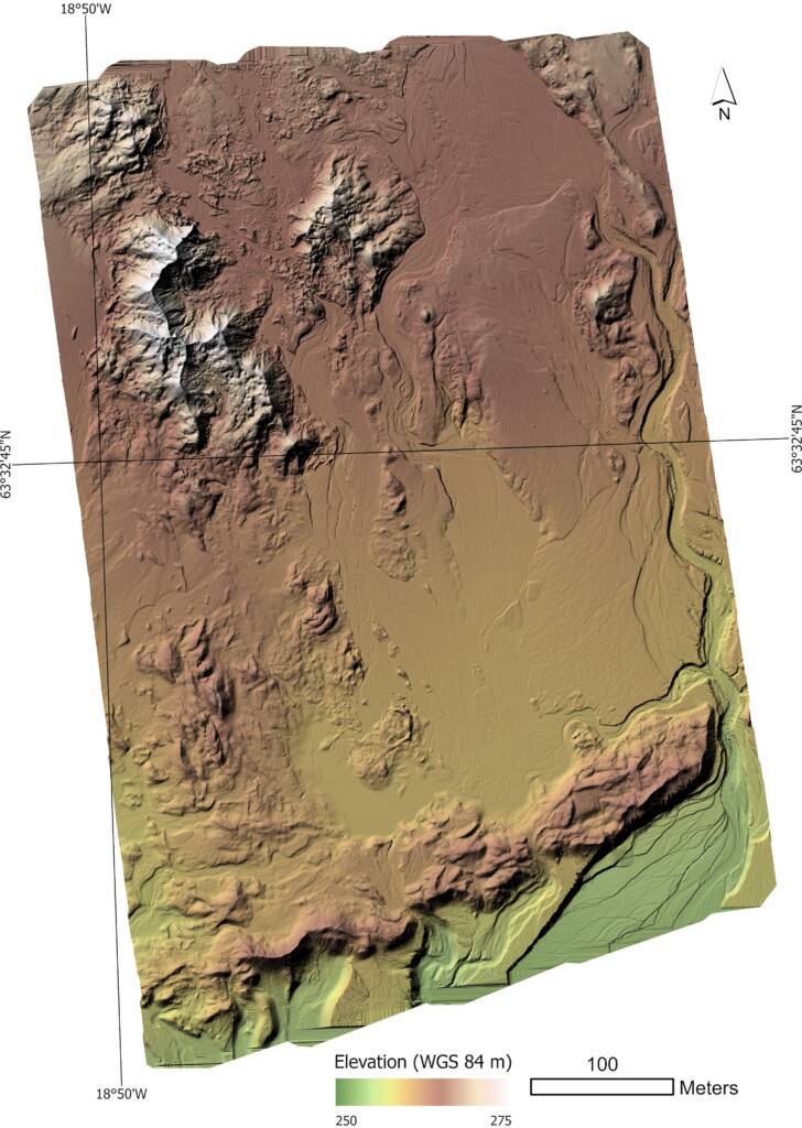
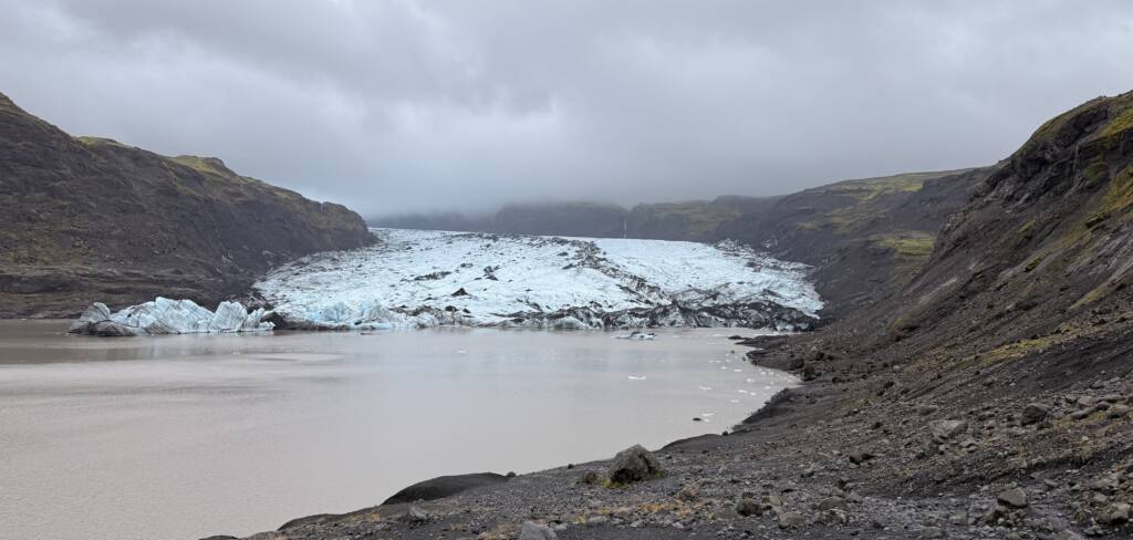
Figure 1: Uncrewed Aerial Vehicle (UAV) LiDAR survey of the Kötlujökull outlet glacier proglacial foreland collected in September 2026. The surveyed region encompasses zones of dead ice, glaciofluvial meltwater systems and other glacial geomorphological features.,Figure 2: The front of the Sólheimajökull glacier (in Sept 2026) – one of the field sites for this research (photo: D. Harrison)
Methodology
This PhD project will involve at least 2 field seasons in southern Iceland working on multiple glacier forelands with important tourist activities (e.g. Kötlujökull, Sólheimajökull) within the Katla Geopark. The research methodology will involve a mixture of both geomatic / geodetic and geophysical survey techniques, supervised by experts at Stirling University, Newcastle University, and the CASE partner (Kelpie Geoscience). Researchers at Kelpie Geoscience are in a working partnership with Katla Geopark staff, and can assist in the field with logistics, planning and data collection. The studentship will involve geomorphological mapping and time-series analysis of high-resolution openly available elevation datasets (e.g. ArcticDEM); geomorphological analysis of newly collected LiDAR datasets; UAV-borne LiDAR and stereo-photogrammetric surveying; high-resolution global navigation satellite system (GNSS) surveys and advanced geospatial data analysis; GPR data collection, processing and interpretation; and time-lapse camera deployment and analysis – all of which will occur within the 3.5 years of the PhD project.
Project Timeline
Year 1
• Systematic review of the literature, liaison with Icelandic partner organisations, examination of available datasets and new (currently unpublished) high-resolution datasets from fieldwork campaigns to enable identification of target sites within the Katla Geopark (Autumn/Winter 2027).
• Completion of UK CAA RPC Level 1 UAV qualification (Autumn/Winter 2027).
• Research design and DTP training methods.
• First Icelandic field season (June/July 2028): UAV surveys (LiDAR and GPR) of ice-marginal and proglacial foreland targets; acquisition of GNSS data; installation of time-lapse cameras; discussions with project partners at the Katla UNESCO Global Geopark and Icelandic Meteorological Office.
• Processing and analysis of data collected during Field Season 1; planning for Field Season 2.
• UK conference presentation (September 2028).
• The PhD researcher will spend at least 4 weeks at Kelpie Geoscience office in Edinburgh.
Year 2
• Advanced training in relevant skills (e.g. NERC Geophysics for Environmental Scientists course; Python/MATLAB for environmental science; advanced geospatial data analysis) (Autumn/Winter 2028)
• Planning for Field Season 2 (Autumn/Winter 2028)
• Second Icelandic field season (June/July 2029): Longer field season to collect UAV LiDAR surveys and geophysical data predicated on results from the first field season; collection of time-lapse camera station; discussion with project partners at Katla UNESCO Global Geopark.
• Ongoing processing and analysis of data collected during Field Seasons 1 and 2 (Autumn/Winter 2028, Summer 2029)
• Manuscript preparation and submission.
• UK or international conference presentation (September 2029).
• The PhD researcher will spend at least 4 weeks at Kelpie Geoscience office in Edinburgh.
Year 3
• Applications for research funding to conduct a potential third field season (Autumn/Winter 2029).
• Continued data processing and analysis (Autumn/Winter 2029)
• Data assimilation and thesis workshop (Spring 2030)
• Manuscript preparation and submission (Spring/Summer 2030).
• International conference presentation (Spring 2030).
• Focused thesis write-up (Spring/Summer 2030).
• The PhD researcher will spend at least 4 weeks at Kelpie Geoscience office in Edinburgh.
• Visit to Iceland to engage with Icelandic stakeholders to report on research findings and applied implications.
Year 3.5
• Finalise and submit PhD Thesis
Training
& Skills
There will be numerous opportunities in this PhD project for the successful candidate to undertake relevant training to develop a multifaceted and highly sought after geoscientific skillset. This training will be conducted in-house at the University of Stirling and Newcastle University and through other external opportunities (e.g. NERC and UKRI training courses). The candidate will be encouraged to prioritise the UK CAA RPC Level 1 drone course to have competency to fly UAVs for scientific data collection. There will be opportunities for the candidate to develop skills in remote sensing, geophysical surveys, field-based geomorphological data collection techniques, ‘big data’ analysis, and stakeholder and public-engagement training all of which are highly sought-after in both academia and industry. The candidate will attend at least 2 major (UK and international) scientific conferences to present their science as well as widening their knowledge base. Opportunities will also exist for the successful candidate to undertake training additional to their PhD research (e.g. the IAPETUS placement scheme). The supervisory team will fully support the PhD researcher in any applications, and have demonstrable track records of facilitating such opportunities.
References & further reading
1. Abrahams, Z., Hoogendoorn, G. and Fitchett, J. M. (2022) Glacier tourism and tourist reviews: an experiential engagement with the concept of “Last Chance Tourism”. Scandinavian Journal of Hospitality and Tourism, 22(1), pp. 1–14. doi:10.1080/15022250.2021.1974545.
2. Ben‐Yehoshua D., Sæmundsson Þ., Helgason J.K., Belart J.M.C., Sigurðsson J.V. and Erlingsson S. (2022) Paraglacial exposure and collapse of glacial sediment: The 2013 landslide onto Svínafellsjökull, southeast Iceland. Earth Surface Processes and Landforms, 47(10), pp. 2612–2627. doi:10.1002/esp.5398.
3. Blauvelt, D. J., Russell, A. J., Large, A. R. G., Tweed, F. S., Hiemstra, J. F., Kulessa, B., Evans, D. J. A. & Waller, R. I. (2020) Controls on jökulhlaup-transported buried ice melt-out at Skeiðarársandur, Iceland: Implications for the evolution of ice-marginal environments. Geomorphology, 360, 107164, doi:10.1016/j.geomorph.2020.107164
4. Cook S.J. (2026) Glacial hazards in Elias, S.A. and Kelly, R. (eds.) Comprehensive Cryospheric Science and Environmental Change, Elsevier, pp. 361–385. doi:10.1016/B978-0-323-85242-5.00059-2.
5. Dunning, S.A., Large, A.R., Russell, A.J., Roberts, M.J., Duller, R., Woodward, J., et al. (2013) The role of multiple glacier outburst floods in proglacial landscape evolution: the 2010 Eyjafjallajökull eruption, Iceland. Geology, 41(10), pp. 1123–1126. doi:10.1130/G34665.1
6. Harrison D., Ross N., Russell A.J. and Dunning S.A. (2019) Post-jökulhlaup geomorphic evolution of the Gígjökull Basin, Iceland. Annals of Glaciology, 60(80), pp. 127–137. doi:10.1017/aog.2019.30.
7. Schomacker, A. and Kjær, K.H. (2008) Quantification of dead-ice melting in ice-cored moraines at the high-Arctic glacier Holmströmbreen, Svalbard. Boreas, 37, pp. 211–225. doi:10.1111/j.1502-3885.2007.00014.x
8. The GlaMBIE Team. (2025) Community estimate of global glacier mass changes from 2000 to 2023. Nature, 639, pp. 382–388. doi:10.1038/s41586-024-08545-z
