

IAP-26-106
Mathematical Modelling of Ecosystem Resilience in a Changing Climate
Ongoing climate change threatens to instigate dramatic changes in ecosystems across the globe, prompting a renewed focus on understanding ecosystem stability and resilience. Vegetation, from forests and savannas to semi-arid drylands, is significantly impacted by extreme weather events (e.g. fires, flooding, drought) and shifts in climate on longer scales (e.g. variations in annual rainfall). Moreover, large, vegetated ecosystems are crucial in carbon capture and the global carbon cycle, as well as underpinning the livelihoods of 2.3 billion people. This project will explore mathematical models of vegetative ecosystems to capture these relationships and answer questions about climate-driven impacts on vegetation.
Existing models of these ecosystems can be arranged into two broad categories: (1) Simplified phenomenological models studied by theoreticians that allow deep understanding of dynamics (Meron, 2011), or (2) Detailed process-based models that are realistic, but difficult to analyse or interpret (Stewart et al, 2014), limiting their utility for assessing ecosystem resilience. Our goal is to use mathematical coarse graining techniques to derive a new class of models that bridge the gap between approaches (1) and (2). These models should faithfully reflect underlying ecological processes but remain tractable enough to allow for detailed understanding of their dynamics (Patterson et al., 2020). This tractability will also enable us to apply resilience metrics and methods from mathematical ecology to interpret model outputs in the context of wider climactic shifts. Finally, our models and outputs will be validated by and compared to remote-sensed data. Overall, this research will enable us to better understand the forces underlying vegetation patterning and resource losses, and the signals that such patterning gives us in terms of early-warning signs of ecosystem change.
This project spans mathematical ecology, ecogeomorphological modelling, and statistical analysis of remote-sensing data. The supervisory team brings together essential expertise spanning environmental science, geography, ecology and mathematics. This collaborative approach is vital to capturing the complexity of the ecological processes of interest and translating research findings into practical insights, including tools such as stakeholder-facing dashboards for decision-making and ecosystem monitoring.


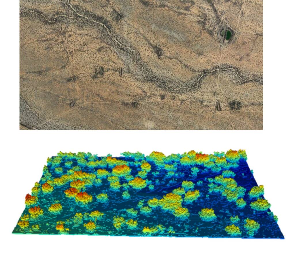
Click on an image to expand
Image Captions
Composite image across grassland-shrubland ecotone, Sevilleta LTER, NM, USA (images Laura Turnbull-Lloyd / John Wainwright),Use of the VisualPDE interface to investigate the behaviour of the simple Klausmeier vegetation-pattern model (https://visualpde.com/sim?mini=k-DtCNOt),Vegetation patterns at different scales in the Sonoran Desert from drone and laser scanning (Laura Turnbull-Lloyd / John Wainwright)
Methodology
Depending on the student, differing amounts of time will be spent on each facet of the project, though some level of engagement across the different approaches will be necessary. They will begin by building on the existing modelling frameworks developed in Durham to create tractable models for spatial fire spread (Patterson et al., 2020) and herbivory (Stewart et al., 2014, Tiwari et al. 2025) that can be compared to remote sensing data. Once the models are validated, we will be to quantify the likelihood of state transitions in patterned semi-arid ecosystems, develop early warning signals for these transitions, and further explore how these systems respond to ongoing climate change.
There will be an emphasis throughout on building interpretable mechanistic models, where modelling assumptions, such as time and length scales where the mechanisms are likely to be valid, are clear. We will explicitly consider a spectrum of modelling approaches to balance different approaches with the need for systematic analyses and comparisons with data. We will leverage mathematical techniques from areas like theoretical ecology to understand dynamical motifs in both simple and detailed models, such as pattern formation as a resilience mechanism for vegetation. The use of landscape-flux theory (Xu et al., 2023), as well as other tools such as bifurcation analysis and continuation, will be used to understand the variety and likelihood of ecosystem transitions expected as climate-relevant parameters vary.
We will co-create stakeholder-facing dashboards allow easy communication of management and policy-relevant lessons. These tools will be built using modern Web frameworks, such as WebGL within JavaScript, that could interface with backend servers for model execution or data access. Examples of existing projects of this form include VisualPDE.com (led by Krause) and LimbNET.embl.es.
Project Timeline
Year 1
– Literature review across mechanistic, statistical vegetation modelling, and ecogeomorphology.
– Gain proficiency in data analysis and mathematical modelling, including compartmental process-based frameworks and partial differential equation models (PDEs).
– Learn simulation and analysis of mathematical models (dynamical systems).
– Analyze simplified ecosystem models.
Year 2
– Connect process-based modelling with simplified models via coarse graining.
– Prepare dashboards and interactive visualizations for communicating findings with public and public-policy audiences.
– Prepare modelling work for publication.
Year 3
– Complete development and testing of the suite of models.
– Compare simplified and mechanistic models to remote-sensed and ground-based datasets (e.g. LTER vegetation databases).
– Interface with stakeholders (e.g. public-policy relevant placement, attend policy-relevant conferences) and present initial dashboards/visualizations for feedback.
– Prepare modelling-empirical comparisons for publication.
Year 3.5
– Present at a major, international conference.
– Finalise remaining work for publication and integrate papers into thesis format.
– Prepare for viva.
Training
& Skills
Scientific training
Training will include ecological and geomorphological modelling (Turnbull-Lloyd, Wainwright), and data analysis covering high-performance computing and remote-sensed vegetation modelling (Sanderson). The student will learn advanced techniques in dynamical systems and partial differential equations (Patterson, Krause), essential for building and analysing complex vegetation models. This broad training is valuable in environmental sciences and other multidisciplinary fields.
Opportunities for career development
Students in the supervisory team’s groups have co-supervised undergraduates, taught practicals, participated in outreach, and held leadership roles. The student will present at conferences and co-author publications. Training in interdisciplinary communication will be highlighted, benefiting future academic, government, or industry careers, alongside placement with a governmental or NGO partner from our network of contacts, which will strengthen stakeholder engagement and provide policy experience.
Research environment
The student joins a multidisciplinary team spanning environmental science and mathematical modelling, providing broad perspectives on climate-relevant science and multidisciplinary research. Durham Geography is the leading Geography Department in the country and 6th Worldwide in the QS World University rankings. There is a vibrant research environment with multiple research clusters and thematic research groups, and frequent seminars. The student will join weekly seminars with Newcastle’s Modelling, Evidence & Public Policy group (5 postdocs, 10 PhD students) led by Sanderson. Collaboration with Patterson’s and Krause’s groups involves the Applied Mathematics Section (10 faculty, 7 postdocs, 5 PhD students), which hosts weekly lunches and seminars. Involvement with the Biophysical Sciences Institute offers cross-disciplinary training, outreach, and enrichment.
To contextualise research, Turnbull-Lloyd and Wainwright provide guidance on dryland ecogeomorphic processes—drawing on experience in the Mediterranean, Africa, and North America—and training in extracting vegetation and fire data from remote sensing.
Dr Sanderson will guide the use of remote-sensed and existing datasets for multi-scale vegetation modelling, maximising prediction utility for sustainable management.
Given the project’s policy impact potential, the student is encouraged to join outreach events (e.g., “Pint of Science”, Durham’s “Celebrate Science”). They will present at key mathematics and ecology conferences, including the British Ecological Society meeting, and the Society for Mathematical Biology Annual meeting.
References & further reading
Butler & Sanderson (2021) A rapid method for quantifying small‐scale vegetation patch structure to complement conventional quadrat surveys. Appl. Veg. Sci., 24, e12610
Butler & Sanderson (2022). National-scale predictions of plant assemblages via community distribution models: leveraging published data to guide future surveys. J. Appl. Ecol., 59, 1559–1571
Stewart, Parsons, Wainwright, Okin, Bestelmeyer, Fredrickson & Schlesinger (2014). Modeling emergent patterns of dynamic desert ecosystems. Ecol. Monogr., 84(3), 373–410.
Meron (2011). Modeling dryland landscapes. Math. Model. Nat. Phenom., 6(1), 163–187.
Patterson, Levin, Staver & Touboul (2020). Probabilistic foundations of spatial mean-field models in ecology and applications. SIAM J. Appl. Dyn. Syst., 19(4), 2682–2719.
Tiwari, Turnbull & Wainwright (2025). Local- and global-scale hydrological and sediment connectivity over grassland and shrubland hillslopes. J. Hydrol., 655, 132896.
Tiwari, Turnbull & Wainwright (2026). The role of connectivity in driving grassland-shrubland regime shifts: impacts of aridity, grazing and wind dynamics, Ecol. Modelling 521, 111735.
Xu, Patterson, Levin & Wang (2023). Non-equilibrium early-warning signals for critical transitions in ecological systems. PNAS, 120(5), e2218663120.
