

IAP-26-107
Controls on glacier retreat and glacier-related hazards in the Greater Caucasus
The melting of mountain glaciers and ice caps worldwide contributed around 18 mm to global mean sea level between 2000 and 2023, with an increase in mass loss of around 36% from the first (2000-2011) to the second half of that period (2012-2023) (The GlaMBIE Team, 2025). Globally, this constitutes a glacier volume loss of around 5% since 2000, but there are marked regional differences, with the largest losses occurring in mid- and low-latitude regions with relatively small glacier areas (The GlaMBIE Team, 2025).
One such region is the Greater Caucasus, which hosts 2,341 glaciers covering an area of around 964 km2 in 2025, spread across Russia (650 km2), Georgia (313 km2) and Azerbaijan (0.5 km2) (Tielidze et al., 2026). This region accounted for the second highest relative ice loss globally between 2000 and 2023, losing 35% of its glacier volume and second only to the central European region (39%) (The GlaMBIE Team, 2025). Indeed, over 900 glaciers (~122.9 km2) have become extinct in the Greater Caucasus since the 1960s, with the rate of area loss now almost 2% per year, driven by increased summer temperatures and declining winter precipitation (Tielidze et al., 2026). Furthermore, projections show that the region could lose between 60% and 100% of glacier volume by 2100 depending on the magnitude of future warming, with near-complete deglaciation projected to occur at around +3 °C above pre-industrial temperatures (Rounce et al., 2023).
Glacier loss in the Caucasus has a negligible impact on global sea level but there are indications that parts of the region may be close to passing ‘peak water’ (Rets et al., 2020) and decreased glacier meltwater runoff will have major impacts on regional water resources for nearby populations (Shahgedanova et al., 2009; Clason et al., 2022). The region has also experienced major glacier-related hazards that have led to hundreds of fatalities, including glacial lake outburst floods (e.g. Chernomorets et al., 2018), rock-ice avalanches (e.g. Haerberli et al., 2004; Evans et al., 2009) and debris flows (e.g. Tielidze et al., 2019). It has also been noted that glacier retreat is leading to the expansion of glacial lakes and supraglacial debris cover (Stokes et al., 2006; 2007; Tielidze et al., 2020), which may increase the potential for glacier-related hazards. The expansion of proglacial/ice marginal lakes has also been linked to accelerated glacier loss in some regions (e.g. Song et al., 2017), but this has not been investigated in the Caucasus.
Despite recent progress, there is limited understanding of how glacier retreat in the Caucasus might evolve in the near future and how this might impact on glacier-related hazards, leading to a number of key research questions. How have glaciers responded to recent warming and what factors control their rate of shrinkage? How has the distribution of glacial lakes and debris covered changed over recent decades and how do these factors modulate glacier change and the potential for glacier-related hazards? Where might future glacier-related hazards (e.g. glacial lake outburst floods) be located and who might be exposed to such hazards? The overall aim of this project is to identify the key controls on glacier retreat and glacier-related hazards in the Greater Caucasus.
The project aim will be achieved through the following key objectives:
1. Use satellite remote sensing to generate a new glacier inventory of the Caucasus region and compare this to previous inventories to analyse glacier retreat over the last few decades and the factors that modulate the response of glaciers to climate change.
2. Use satellite remote sensing to analyse changes in glacial lakes and supraglacial debris cover over the last few decades and examine their role in modulating glacier retreat.
3. Use the mapping of glacial lakes over the last few decades (from 2), alongside other key datasets (e.g. digital elevation models; landslide mapping; flood modelling), to evaluate their susceptibility to glacial lake outburst floods (GLOFs) and identify communities most at risk.
Note: dependent on the student’s interests and skills, we anticipate a fieldwork component to the project and the possibility of engaging with local communities in terms of risk awareness and preparedness (e.g. Rinzin et al., 2026a). There may also be an opportunity to undertake some numerical modelling of future glacier change, if desired.
Click on an image to expand
Image Captions
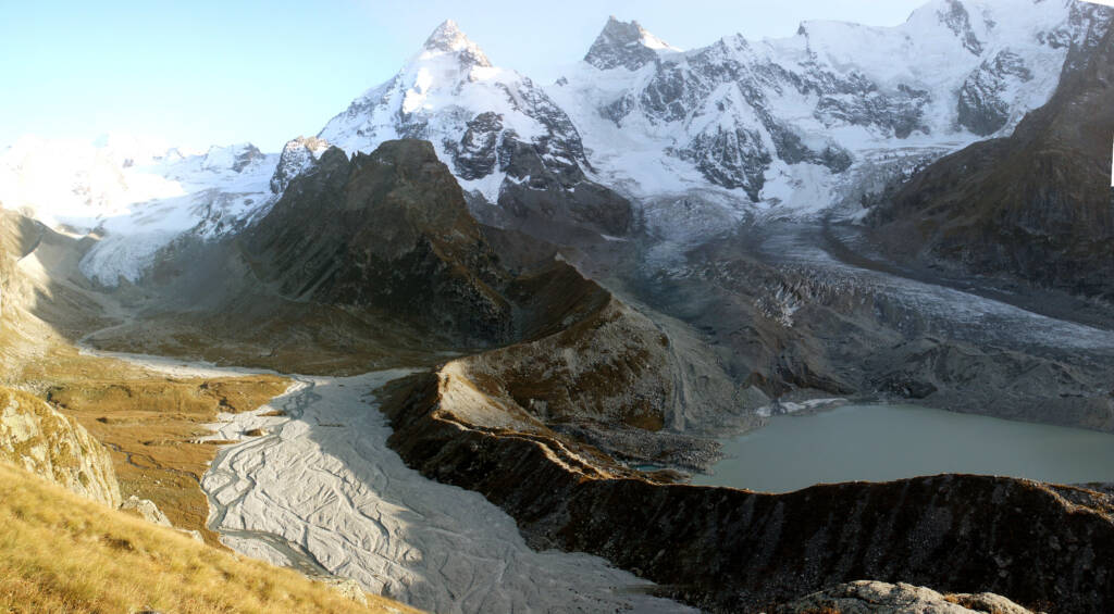
Photograph of the Djankuat (left) and Bashkara glacier (right), including the Bashkara lake impounded by a large lateral moraine, prior to its drainage in September 2017 (photo: A. Aleynikov).
Methodology
The project will primarily use a combination of remote sensing methods but fieldwork is anticipated (in Georgia) and there is scope to incorporate numerical modelling and/or engage with local communities, dependent on student interests and skills.
The primary research tools will involve acquisition and analysis of multiple remote sensing datasets within a GIS (Geographical Information Systems) framework. Automated/semi-automated mapping procedures will be favoured (e.g. Stokes et al., 2018), where possible, but may be supplemented with manual mapping and ‘ground truthing’ in the field. Assessment of glacier hazards, such as GLOFs, is likely to involve the collection of a diverse range of environmental datasets for multi-criteria hazard assessment frameworks (e.g. Khadka et al., 2021). As noted above, the project may also incorporate flood modelling and assessment of downstream exposure (e.g. Rinzin et al., 2026b) and community engagement (Rinzin et al., 2026a), depending on student interests and skills.
The project supervisors have a strong track record of research and supervision of mountain glacier change, including in the Caucasus, and the student will also benefit from an external supervisor (Dr Levan Tielidze) affiliated to Ilia State University, Georgia.
Project Timeline
Year 1
Training in remote Sensing and GIS; review of relevant literature and existing glacier inventories; refining project aims and objectives; collection and analysis of remote sensing datasets; attendance at relevant training workshops and summer schools; national conference attendance.
Year 2
Mapping of glacier change and associated changes in glacial lakes and supraglacial debris cover; preparation of manuscript(s) on drivers and controls on glacier change; possible fieldwork and analysis of field data; preparation of manuscript of manuscript on changes in debris cover and glacial lakes; possibility of numerical modelling of future glacier change; conference attendance
Year 3
Evaluation of glacial lake outburst flood risk and exposure; possibility of flood modelling and/or community engagement, with further fieldwork; submission of manuscript on GLOF risk assessment and impacts; international conference; begin thesis writing
Year 3.5
Complete publication of research papers; compilation and submission of thesis; possibly conference attendance; wider career development support and training
Training
& Skills
Where necessary, the student will be supported through both generic and bespoke training in remote sensing and GIS techniques, including software such as QGIS and ArcGIS. They will be trained in field data collection techniques, which may be supplemented through formal training courses, such as the Natural Environment Research Council (NERC) British Antarctic Survey (BAS) Advanced Training Course on Polar Fieldwork. Broader transferable skills (e.g. communicating science, policymaking, media engagement, thesis writing, writing for publication, presentation skills) will be developed through various training events at Durham University offered by Iapetus.
References & further reading
Clason, C., Rangecroft, S., Owens, P.N. et al. (2022) Contribution of glaciers to water, energy and food security in mountain regions: current perspectives and future priorities. Annals of Glaciology, 63 (87-89), 73-78.
Chernomorets, S.S. et al. (2018) The outburst of Bashkara Glacier Lake (Central Caucasus, Russia) on 1 September 2017. Kriosf. Zemli, XXII, 61–70.
Evans, S.G. et al. (2009) Catastrophic detachment and high-velocity long-runout flow of Kolka Glacier, Caucasus Mountains, Russia in 2002. Geomorphology 2009, 105, 314–321.
Haeberli, W. et al. (2004) The Kolka-Karmadon rock/ice slide of 20 September 2002: an extraordinary event of historical dimensions in North Ossetia, Russian Caucasus. Journal of Glaciology, 50 (171), 533-546.
Khadka, N. et al. (2021) Evaluation of Glacial Lake Outburst Flood susceptibility using multi-criteria assessment framework in Mahalangur Himalaya. Front. Earth Sci. 8, 601288.
Rets, E.P., Durmanov, I.N., Kireeva, M.B. et al. (2020) Past ‘peak water’ in the North Caucasus: deglaciation drives a reduction in glacial runoff impacting summer river runoff and peak discharges. Climatic Change 163, 2135–2151.
Rinzin, S., Dunning, S., Carr, R., et al. (2026a) Public warning and evacuation experiences during recent GLOF events (2019 and 2023) and recommendations for future preparedness: Insights from Lunana, Bhutan. International Journal of Disaster Risk Reduction, 142, 106211.
Rinzin, S., Dunning, S., Carr, R.J., et al. (2026b) Advancing glacial lake hazard and risk assessment in Bhutan through hydrodynamic flood mapping and exposure analysis. Natural Hazards and Earth System Sciences, 26 (2), 1015-1037.
Rounce, D.R. et al. (2023) Global glacier change in the 21st century: every increase in temperature matters. Science, 379,78-83.
Shahgedanova, M., Hagg, W., Hassell, D., Stokes, C.R. & Popovnin, V. (2009) Climate change, glacier retreat, and water availability in the Caucasus region. In, Jones, J.A.A., Vardanian, T.G. & Hakopian, C. (Eds) Threats to Global Water Security. NATO Science for Peace and Security Series C – Environmental Security, Springer, Netherlands, p. 131-143.
Song, C. et al. (2017) Heterogeneous glacial lake changes and links of lake expansions to the rapid thinning of adjacent glacier termini in the Himalayas. Geomorphology, 280, 30–38.
Stokes, C.R., Gurney, S.D., Shahgedanova, M. & Popovnin, V. (2006) Late twentieth century changes in glacier extent in the Caucasus Mountains, Russia. Journal of Glaciology, 52 (176), 99-109.
Stokes, C.R., Popovnin, V, Aleynikov, Gurney, S.D. & Shahgedanova, M., (2007) Recent glacier retreat in the Caucasus Mts, Russia, and associated increase in supraglacial debris cover and supra/proglacial lake development. Annals of Glaciology, 46, 195-203.
Stokes, C.R., Andreassen, L.M., Champion, M.R. and Corner, G.C. (2018) Widespread and accelerating glacier retreat on the Lyngen Peninsula, northern Norway, since their ‘Little Ice Age’ maximum. Journal of Glaciology, 64 (243), 100-118.
The GlaMBIE Team (2025) Community estimate of global glacier mass changes from 2000 to 2023. Nature 639, 382–388.
Tielidze, L.G., Bolch, T., Wheate, R.D., Kutuzov, S.S., Lavrentiev, I. I. & Zemp, M. (2020) Supra-glacial debris cover changes in the Greater Caucasus from 1986 to 2014. The Cryosphere, 14, 585–598.
Tielidze, L.G., Kumladze, R.M., Wheate, R.D., & Gamkrelidze, M. (2019) The Devdoraki Glacier catastrophes, Georgian Caucasus. Hung. Geogr. Bull., 68, 21–35.
Tielidze, L. G., Nosenko, G. A., Nadaraia, A., Khromova, T. E., Kumladze, R. M., Clason, C. C., Elashvili, M., & Gadrani, L. (2026) A 2025 high-resolution glacier inventory of the Greater Caucasus reveals accelerated area loss. Remote Sensing, 18(9), 1441
