

IAP-26-044
Finding and protecting Scotland’s hidden groundwater-dependent ecosystems
Groundwater-dependent ecosystems (GDEs) are ecosystems that rely on groundwater for some or all of their water needs. Example GDEs include streams, springs, wetlands, and phreatophytes (plants whose root systems source water from the water table or capillary fringe). GDEs are habitat to biodiversity hotspots, perform crucial biogeochemical functions, and are important to people through cultural (e.g. holy springs) and recreational practices. GDEs are legally protected in Scotland and across Europe through the Water Framework Directive, yet there remains no comprehensive understanding of GDE locations and pressures across Scotland.
GDEs are most commonly mapped in drylands, where remote sensing techniques are more amenable to the identification of GDE locations (e.g., Rohde et al. 2024). This project will advance state-of-the-art methods to understand the location of GDEs in energy-limited environments, and thus holds great potential to inform broader, global efforts to more systematically understand GDE locations outside of drylands.
There are several gaps and research frontiers this project works along, all of which are poised for high-impact outputs for both science and environmental policy:
1. GDE mapping across Scotland is piece-meal. Presently, GDE mapping only occurs for development applications and land use assessments. There remains no comprehensive assessment of the locations and compositions of GDEs across Scotland.
2. Initiatives worldwide have focused on GDE mapping in drylands. There is a wide opportunity to refine how GDEs are mapped in humid, energy-limited environments through geospatial data integration, process based modelling, and field work.
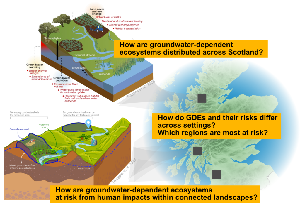
3. GDEs require landscape-scale protection (Saito et al. 2025), including the consideration of groundwater flow paths that contribute to GDEs. “Groundwatersheds”, the area that supplies groundwater to a feature of interest (Huggins et al. 2023), have not yet been delineated at high-resolution using a groundwater model within Scotland. Doing so enables a comprehensive assessment of land use risks on GDEs at the integrative landscape scale that is necessary for robust protection.
Momentum is growing globally and within the United Kingdom on GDE science. The first global maps of GDEs have recently been published (Rohde et al. 2024; Huggins et al. 2023; Link et al. 2023), the Environment Agency has begun mapping GDEs across England, and GDEs are becoming a priority for integrative freshwater and ecosystems science and policy (Huggins et al. 2026). There is also a great need: GDEs, along with other subterranean environments, contribute to three-quarters of all classified ecosystem services (Mammola et al. 2026). This project will operate at, and advance, the forefront of abilities to understand GDE locations beyond drylands and their risks. It represents a high-potential opportunity to contribute high-impact methods across the ecohydrogeology community, which are crucial to achieve effective landscape management of our interconnected natural systems.
Click on an image to expand
Image Captions
Research questions motivating this PhD project.
Methodology
Research theme 1: Scotland’s first comprehensive GDE map.
Research question: How can GDEs be detected in energy-limited environments?
Theme 1 will produce Scotland’s first comprehensive GDE map. Reference data of likely GDE areas will be sourced from various initiatives, including: NatureScot designated sites, groundwater-dependent habitats in Special Areas of Conservation, and vegetation surveys in environmental impact assessments. For data-driven modelling of GDE presence and classification across Scotland, predictor variables will include vegetation greenness and soil moisture, particularly during drought conditions (e.g., Sentinel-2 and Landsat datasets), land surface temperature anomalies representing groundwater discharge (e.g., Landsat, ECOSTRESS), surface saturation (e.g., Sentinel-1), myriad hydrogeological datasets (e.g., geological units, permeability, topographic wetness index, slope, superficial deposits, etc.), vegetation cover maps, water table depth and discharge regions (groundwater model outputs). A probabilistic machine-learning classifier (such as a Random Forest) will estimate each pixel’s likelihood of GDE presence, GDE composition, and uncertainty in both. Based on the initial outputs of the mapping exercise a number of field sites will be selected to provide field-site validation of predictions using multiple lines of evidence: vegetation surveys, water table measurements and hydrochemical tracers.
Research theme 2: Scotland’s GDE risk landscape.
Research question: Where are Scotland’s GDEs most exposed to the cumulative landscape risks of land use, contamination, warming and drought?
Risks to GDEs identified through Theme 1 will be assessed by considering exposure and cumulative impacts. Exposure to risks will be evaluated by considering land use and drainage, contamination and groundwater vulnerability datasets, groundwater warming, drought and groundwater abstraction and storage trends. Many pressures located away from a GDE’s physical extent can still impact it through lateral groundwater flow. Exposure will be assessed across GDE groundwatersheds, which are hydrogeological catchments from which groundwater flows to features of interest (Huggins et al. 2023). Cumulative risks will be determined across groundwatersheds to inform prioritisation mapping for future GDE conservation initiatives. Groundwatersheds will be dynamically delineated using multi-decadal simulated heads from a numerical groundwater model. This model could be developed by the student, or taken “off the shelf” (such as the British Groundwater Model; Bianchi et al. 2024), depending on the student’s interests and assessment of existing model abilities. The model will also inform an evaluation of the likely timing of impacts on GDEs.
Research theme 3: Scotland’s GDE futures.
Research question: How might Scotland’s GDEs change under alternative future land use, water use and climate scenarios?
Finally, Theme 3 will develop an understanding of how GDEs may change under different future scenarios of land use, water use and climate. For this, the project will use the UK Shared Socioeconomic Pathways (UK-SSPs), alternative land use scenarios (CRAFTY-GB projections), and UK climate projections (UKCP18). Alternative policy scenarios, such as woodland expansion or peatland restoration will be developed, and will result in updated boundary conditions (e.g., recharge, pumping) to the groundwater model. This final theme will link inputs across all themes in the PhD project, as these scenarios will provide a reference point regarding (1) how present-day GDE extents and compositions are likely to change in future scenarios, and (2) where area-based conservation efforts, such as restoring drained land, would be most effective to maintain overall GDE health within Scotland.
Project Timeline
Year 1
– Training: induction, IAPETUS cohort training, training with remote sensing and machine learning; groundwater modelling training during a placement at BGS Edinburgh.
– Begin work within Theme 1: literature review; compile the inventory of existing GDE sites; assemble database of predictor datasets; review of existing groundwater models and applicability for GDE mapping; pilot the Random Forest model in the case study field sites.
– First summer field season, including installing groundwater leveloggers for continuous water table monitoring; vegetation surveys, water table depth, water chemistry, and temperature.
Outputs:
– first-year progress review.
Year 2
– Major focus: completing work related to Theme 1: Scotland-wide classification with spatial cross-validation and uncertainty mapping.
– Begin work on Theme 2: compile database of GDE risk layers; delineate groundwatersheds from BGWM simulated heads.
– Begin work on Theme 3: scenario design and data requests.
– Fieldwork: second field season, with a focus on collecting data to test the GDE map and groundwater model outputs.
Outputs:
– Paper 1 submission (Scotland’s first comprehensive GDE map)
– Attend and present at the European Geosciences Union (EGU) General Assembly
Year 3
– Complete work on Theme 2: assess cumulative exposure across groundwatersheds, and identify potential timing and severity impacts to guide identification of priority areas for GDE conservation.
– Continue work on Theme 3: finalise boundary conditions associated with scenarios from the UK-SSPs, land use and climate projections, and policy scenarios. Run associated BGWM simulations.
– Fieldwork: final visit to retrieve loggers.
Possible forms of engagement:
– Convene a workshop with key actors (e.g., NatureScot, SEPA, and local decision makers) to share results
Outputs:
– Submission of paper 2 (Scotland’s GDE risk landscape)
– Attend and present at the European Geosciences Union (EGU) General Assembly or another international conference (e.g., World Groundwater Congress)
Year 3.5
– Complete analysis on Theme 3
Outputs:
– Paper 3 submission (Scotland’s possible GDE futures).
– Public release of the Scotland GDE atlas as a web map.
– Data and code deposition (BGS National Geoscience Data Centre, Zenodo, GitHub).
Guidance note for NatureScot and SEPA on using the map and groundwatersheds in Nature Networks and groundwater-dependent terrestrial ecosystem assessments.
– Thesis submission.
Training
& Skills
This project provides training across ecohydrogeology, field hydrogeology, remote sensing, groundwater modelling, scenario analysis and environmental data science, through the University of Glasgow and the British Geological Survey (BGS).
During the first year, the student will receive training in research methods and core transferable skills as part of the PhD cohort. Throughout the PhD, the student will be offered the opportunity to audit MSc and undergraduate courses at the University of Glasgow in remote sensing, geographic information systems, hydrogeology and statistical modelling. The student will also complete training in Earth observation and in wetland vegetation identification. All analysis will be scripted in Python or R, and the student will be trained in reproducible, version-controlled workflows (Git, GitHub) and in sharing code and data openly according to FAIR principles.
The student will join a strong and supportive research network, with a supervisory team that is highly connected to the global GDE mapping and British hydrogeology research communities. The student will have the ability to join the Freshwater Systems Science Workshops (co-led by Dr Huggins, an initiative that brings PhDs, postdocs, and PIs from leading universities across Sweden, the Netherlands, Finland, and Germany together to collaborate and share progress on freshwater resilience related research outputs). The student will also be encouraged to attend School research seminars, across both ‘Earth, Climate, and Biosphere’ and ‘Geocomputation Data Science and AI’ clusters, in addition to group meetings.
The student will spend time at BGS Edinburgh, working alongside BGS hydrogeologists and groundwater modellers , datasets and networks across Scottish hydrogeology. BGS will provide training in field hydrogeology, along with field and water monitoring equipment. The student will also be part of the BGS University Funding Initiative (BUFI) programme at BGS, which provides opportunities to present their work at an annual BUFI science festival and attend BGS training courses.
In sum, the student will develop expertise in:
– Ecohydrogeology
– Field hydrogeology
– Remote sensing
– Probabilistic machine learning and spatial statistics
– Groundwater modelling
– Scenario analysis of land use, water use and climate futures
– Scripting in Python or R, and best practices regarding reproducible workflows and open sharing of code and data
– Science–policy translation and stakeholder engagement.
References & further reading
Bianchi, M. et al. (2024). Simulation of national-scale groundwater dynamics in geologically complex aquifer systems: an example from Great Britain. Hydrological Sciences Journal, 69(5), 572–591. doi:10.1080/02626667.2024.2320847
Huggins, X. et al. (2023). Overlooked risks and opportunities in groundwatersheds of the world’s protected areas. Nature Sustainability, 6, 855–864. doi:10.1038/s41893-023-01086-9
Huggins, X. et al. (in review). Groundwater-dependent ecosystems are missing from global research and policy agendas. EarthArXiv. doi:10.31223/X5D22K
Link, A. et al. (2023). Groundwater-dependent ecosystems at risk – global hotspot analysis and implications. Environmental Research Letters, 18, 094026. doi:10.1088/1748-9326/acea97
Mammola, S. et al. (2026). Subterranean environments contribute to three-quarters of classified ecosystem services. Biological Reviews, 101, 1582–1605. doi:10.1002/brv.70137
Rohde, M.M. et al. (2024). Groundwater-dependent ecosystem map exposes global dryland protection needs. Nature, 632, 101–107. doi:10.1038/s41586-024-07702-8
Saito, L. et al. (2025). Strategies to address risks to groundwater dependent ecosystems. Hydrological Processes, 39, e70229. doi:10.1002/hyp.70229
