

IAP-26-114
Deciphering the evolution of the hidden landscape beneath the Antarctic Ice Sheet
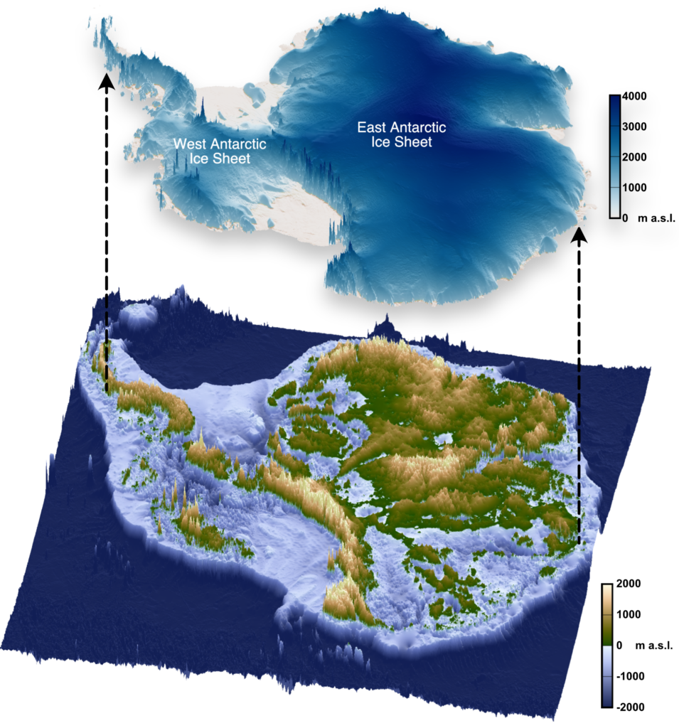
The landscape hidden beneath the Antarctic Ice Sheet (Figure 1) is one of the most mysterious not just on Earth, but on any terrestrial planet in the solar system. The ice sheet that conceals >99% of the Antarctic continent has the capacity to raise global sea levels by around 58 metres and is forecast to become an increasingly important contributor to sea-level rise through the 21st Century and beyond.
However, Antarctica’s future contribution to global sea-level rise is subject to large uncertainties. Two of the principal reasons for this are: (i) poor understanding of the physical conditions at the base of the ice sheet (e.g., basal friction, ice thermal state, geological structure), and (ii) lack of knowledge of the response of the ice sheet to episodes of warming in the geological past that can serve as analogues for future change (Siegert et al., 2020). An improved understanding of the geological and surface processes imprinted in the subglacial landscape will help directly address these sources of uncertainty.
The aim of this project is to constrain the geological and Earth surface processes that have shaped the hidden landscape of Antarctica and use this to improve understanding of long-term and contemporary ice-sheet behaviour.
The subglacial landscape is a significant untapped repository of information relating to Antarctica’s geological evolution and ice-sheet history. This PhD research project is particularly timely for multiple reasons. First, it has been recognised that landscape morphology can reveal important variations in bedrock geology, which can themselves exert a significant influence on ice flow (e.g., Paxman et al., 2026). However, the relationship between subglacial geology and topography remains poorly understood. Second, ‘relic’ landscapes formed prior to glaciation or during a fundamentally different glacial regime to today have been found to be preserved beneath parts of the ice sheet (e.g., Jamieson et al., 2023; Paxman et al., 2025). However, the distribution of these landscapes across Antarctica has not been systematically mapped, and the constraints they offer for long-term and contemporary ice dynamics are yet to be fully utilised. Third, recent advances in mapping topographic structure beneath the ice sheet using the morphology of the more readily observable ice surface have been led by researchers at Durham and Newcastle Universities (e.g., Ross et al., 2014; Lea et al., 2024). These results present exciting opportunities for characterising and interpreting subglacial landscapes that have not previously been detected.
The student will build on previous work by the project supervisors (see above) to decipher the evolution of the subglacial landscape of Antarctica and constrain the long-term behaviour of the ice sheet. The PhD project will involve geomorphic and geophysical analysis to map the distribution of distinct ‘styles’ of landscape and constrain the processes responsible for shaping Antarctica’s topography. The student will also utilise analytical/numerical modelling to understand the relationship between the landscape and the evolution of the ice sheet. The project outputs will feed directly into the state-of-the-art numerical models that are used to simulate Antarctic Ice Sheet evolution and sea-level rise in a warming world.
The project is multi-disciplinary, with opportunities for the student to develop expertise in a combination of geomorphic and geophysical data analytical techniques and numerical modelling of tectonic deformation, landscape evolution, and ice-sheet dynamics. There is scope to weight the project more towards certain processes depending upon student interests.
The student will be embedded in the ‘Sea Level, Ice and Climate’ research cluster in the Department of Geography in Durham, which is world-leading in the study of glacial landscapes, ice-Earth interactions, and ice-sheet history. The student will develop sought-after transferable skills working with polar geophysical data (i.e., radar, gravity, and magnetics), analytical modelling, and/or numerical modelling. More broadly, this project will be closely linked with the INSTANT (INStabilities and Thresholds in ANTarctica) and AGE (Antarctic Geosphere Evolution) scientific research programmes within the 46-nation Scientific Committee on Antarctic Research, and the student will benefit from significant interaction with this international community.
Click on an image to expand
Image Captions
Figure 1: The land surface beneath the Antarctic Ice Sheet. Graphics available via the open-access s-ink.org repository.
Methodology
The project will make use of large, openly available geophysical datasets (including radar-derived bed topography, gravity and magnetic anomalies, and seismic data) acquired by the British Antarctic Survey and international partners over the past decade. The student will also utilise digital elevation models developed by researchers in Durham that contain higher-fidelity information derived from ice-surface morphology. The student will collate and analyse these datasets to gain an understanding of the tectonic and surface processes that have shaped the present-day subglacial landscape in key regions of Antarctica. Geophysical data visualisation and analysis will be carried out in Geographic Information Systems (GIS) software, programming interfaces such as MATLAB and/or Python, and proprietary geophysical software. The student will build on existing computer code provided by the project supervisors, as well developing their own scripts. There will also be opportunities to explore machine learning techniques and/or numerical modelling depending on the interests of the candidate.
The project has three core methodological goals, although their respective emphasis is flexible and dependent on student interests. (1) Quantify the distribution of subglacial landscapes that have been preserved beneath the Antarctic Ice Sheet since prior to or during the early stages of glaciation. (2) Interrogate the relationship between geological and/or tectonic structure and landscape morphology. (3) Use these findings to constrain ice-sheet dynamics and boundary conditions, including basal thermal state (i.e., whether ice is frozen to the bed or thawed), and in turn evaluate the numerical models used to simulate ice-sheet behaviour, which currently do not incorporate constraints from the subglacial landscape. The results of this analysis will be used to generate a step-change in our understanding of long-term Antarctic Ice Sheet evolution and the validation of the numerical models used to project its future change.
Depending on computational demands, data analysis and modelling will be performed locally on the student’s own device and/or on the Hamilton8 supercomputer at Durham University. Durham is equipped with excellent supercomputing provision, with access to key analytical and modelling software such as MATLAB and the Parallel Ice Sheet Model (PISM).
The methods described here can be applied to multiple target regions in Antarctica. Options for study areas include (but are not limited to) buried mountain ranges such as in Dronning Maud Land and the Antarctic Peninsula, or deep subglacial basins such as Recovery and Wilkes.
Project Timeline
Year 1
Preliminary literature review, assessment and selection of potential study areas using satellite imagery, ice-sounding radar data, and digital elevation models. Identification of research questions and objectives. Training in high-performance computing and coding. Generate ‘inventory’ of relic landscapes. Begin to develop first paper.
Year 2
Use geomorphic and geophysical analysis to constrain the geological and surface process(es) responsible for the development of mapped relic landscapes. Attend summer school on ice sheets and glaciers in the climate system. Present findings at UK and international conferences. Begin to develop second paper.
Year 3
Use results of geomorphological and geophysical analysis to evaluate numerical ice-sheet model output. Perform own ice-sheet modelling experiments to gain understanding of long-term landscape preservation. Present outcomes at international Antarctic-focussed conference. Begin to draft thesis.
Year 3.5
Complete and submit thesis; finalise manuscripts for publication; attend UK conference.
Training
& Skills
Techniques in geophysical data analysis and interpretation, machine learning, and/or numerical modelling will form the core of this project. Development of the necessary skills will be facilitated through in-house expertise in Durham and Newcastle, via NERC researcher training events, and via internationally recognised summer schools (e.g., Karthaus).
Further training in transferable skills, including project management, scientific writing, oral and written communication, and media and public engagement, is available via the award-winning Durham Centre for Academic Development (DCAD). The student will also benefit from cross-disciplinary training provided as part of the Iapetus DTP. In respect of this project, two of the most relevant training courses are the ‘Introduction to modelling in Python’ and ‘Advanced statistics in R’ modules, but we will discuss the student’s needs and interests at the outset of the project.
The student will be encouraged to present their work at conferences and seminars at Durham, regional networking events in North East England, and attend relevant national and international conferences throughout the course of their PhD research. The student is also encouraged to apply for small grants from the Royal Geographical Society, British Society for Geomorphology, and Scientific Committee on Antarctic Research, which will allow them to gain experience with writing funding proposals.
References & further reading
Jamieson, S. S. R., Ross, N., Paxman, G. J. G., Clubb, F. J., Young, D. A., Yan, S., Greenbaum, J., Blankenship, D. D. and Siegert, M. J. (2023). An ancient river landscape preserved beneath the East Antarctic Ice Sheet. Nature Communications, 14(1), 6507. https://doi.org/10.1038/s41467-023-42152-2
Lea, E. J., Jamieson, S. S. R., Bentley, M. J. (2024). Alpine topography of the Gamburtsev Subglacial Mountains, Antarctica, mapped from ice sheet surface morphology. The Cryosphere, 18(4), 1733-1751. https://doi.org/10.5194/tc-18-1733-2024
Paxman, G. J. G., Jamieson, S. S. R., Ross, N., Bentley, M. J., Carter, C. M., Jordan, T. A., Cui, X., Lang, S., Sugden, D. E. and Siegert, M. J. (2025). Extensive fluvial surfaces at the East Antarctic margin have modulated ice-sheet evolution. Nature Geoscience, 18(8), 724-731. https://doi.org/10.1038/s41561-025-01734-z
Paxman, G. J. G., Clubb, F. J., Jamieson, S. S. R., Densmore, A. L. (2026). Valley longitudinal profiles record the fluvial landscape evolution and geological structure of the Gamburtsev Subglacial Mountains, East Antarctica. Earth Surface Dynamics, 14(4), 575-599. https://doi.org/10.5194/esurf-14-575-2026
Ross, N., Jordan, T. A., Bingham, R. G., Corr, H. F., Ferraccioli, F., Le Brocq, A., Rippin, D. M., Wright, A. P., Siegert, M. J. (2014). The Ellsworth subglacial highlands: inception and retreat of the West Antarctic Ice Sheet. GSA Bulletin, 126(1-2), 3-15. https://doi.org/10.1130/B30794.1
Siegert, M., Alley, R. B., Rignot, E., Englander, J., & Corell, R. (2020). Twenty-first century sea-level rise could exceed IPCC projections for strong-warming futures. One Earth, 3(6), 691-703. https://doi.org/10.1016/j.oneear.2020.11.002
