

IAP-26-083
Climate-driven biogeochemical changes across the late glacial-interglacial transition: developing ultra-high-resolution lake sediment records using novel scanning techniques
The Late Glacial-Interglacial Transition (LGIT) represents one of the most significant intervals of environmental change during the Quaternary, encompassing rapid climatic fluctuations, fundamental ecosystem reorganisation, and major shifts in terrestrial and aquatic biogeochemical cycling. Across the United Kingdom, sedimentary archives preserve a detailed record of these transformations, offering a unique opportunity to investigate the mechanisms through which climate change influences the cycling and storage of carbon, nutrients, and trace elements across landscapes. While previous palaeoenvironmental reconstructions have provided important insights into the timing and nature of climatic and ecological change, many studies remain constrained by the spatial and temporal limitations of conventional analytical approaches.
Recent advances in non-destructive core scanning technologies, including hyperspectral imaging across the visible-near infrared to short-wave infrared (VNIR-SWIR) spectrum and Laser-Induced Breakdown Spectroscopy (LIBS), offer unprecedented opportunities to characterise sediment composition at sub-millimetre resolution and generate continuous geochemical and mineralogical records. This project will advance the development and application of these emerging methodologies to establish robust proxies for environmental change and to reconstruct climate-driven biogeochemical dynamics across the LGIT in the UK. By integrating methodological innovation with high-resolution palaeoenvironmental reconstruction, the research will provide new insights into the interactions between climate forcing, ecosystem development, and biogeochemical processes during a period of rapid environmental transition, while contributing novel analytical frameworks for the investigation of past environmental change.
This PhD will develop and apply these emerging technologies to generate novel records of climate-driven biogeochemical change across the LGIT in the UK. The research has two overarching aims:
(1) to advance and validate the use of VNIR-SWIR hyperspectral imaging and LIBS as quantitative palaeoenvironmental proxies through methodological development, calibration, and integration with conventional geochemical analyses;
(2) to utilise these approaches to reconstruct high-resolution records of environmental and biogeochemical change across key UK sedimentary archives spanning the LGIT.
By integrating methodological innovation with palaeoenvironmental reconstruction, the project will establish new analytical frameworks for sedimentary geochemistry while providing fundamental insights into the response of biogeochemical systems to rapid climate change.


Click on an image to expand
Image Captions
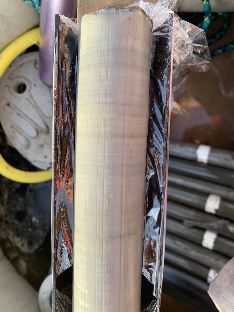
From: Lin et al., 2025. High-Resolution Reconstruction of Total Organic Carbon Content in Lake Sediments Using Hyperspectral Imaging. Remote Sens. 2025, 17(4), 706. https://doi.org/10.3390/rs17040706,Candidate late glacial-interglacial lake sediment site,Late glacial laminations in a lake sediment record from the UK
Methodology
This PhD will develop and evaluate the analytical capabilities of an integrated Laser-Induced Breakdown Spectroscopy (LIBS) and Visible-Near Infrared to Shortwave Infrared (VNIR-SWIR) Hyperspectral Imaging (HSI) platform for sedimentary palaeoenvironmental research. The student will first establish an experimental framework using reference materials, synthetic mineral mixtures, and natural sediment samples to assess analytical performance, quantify matrix effects, and calibrate spectral responses against conventional mineralogical and geochemical techniques, including X-ray diffraction (XRD) and pigment analyses. Data fusion approaches combining LIBS and HSI datasets through multivariate statistics and machine-learning methods will be developed to generate quantitative elemental and mineralogical maps and to evaluate reproducibility, precision, and spatial resolution relative to established techniques such as scanning XRF, micro-XRF and micro-CT.
The calibrated LIBS-HSI platform will then be applied to lake sediment archives spanning a range of environmental settings and temporal scales to reconstruct climate-driven biogeochemical change. Potential case studies include varved, carbonate-rich, organic-rich and glaciolacustrine sediments, with opportunities to investigate seasonal variability, abrupt climate events, catchment processes, carbon cycling, nutrient dynamics and anthropogenic environmental change. Working in partnership with Geotek through a CASE studentship, the student will contribute directly to the development of analytical protocols while generating novel palaeoenvironmental records. The research will test the hypotheses that (1) integrated LIBS-HSI datasets can provide robust quantitative reconstructions of sediment composition, (2) combined elemental and spectral datasets offer greater palaeoenvironmental sensitivity than existing scanning methods, and (3) these approaches can resolve previously unrecognised biogeochemical responses to climatic and environmental change preserved within sediment archives.
Project Timeline
Year 1
• Conduct a comprehensive literature review of LIBS, VNIR-SWIR hyperspectral imaging (HSI), sediment core scanning technologies, and their applications within palaeoenvironmental and palaeoclimate research.
• Review the UK’s key Late Glacial-Interglacial Transition (LGIT) archives and identify potential target sites based on sediment continuity, chronological control and existing proxy datasets.
• Design an experimental framework to evaluate the analytical performance of the integrated Geotek LIBS-HSI platform.
• Develop calibration datasets using certified reference materials, synthetic mineral mixtures, and sediment analogues representative of common lacustrine environments.
• Investigate LIBS matrix effects and establish protocols for reproducible data acquisition.
• Develop VNIR-SWIR calibration workflows using mineralogical and geochemical analyses (e.g., XRD, HPLC and conventional geochemistry).
• Establish the computational and data-management environment for spectral processing, machine learning, and data fusion.
• Undertake a 3-month placement at Geotek to develop expertise in LIBS-HSI operation and gain broader experience of commercial core-scanning technologies.
• Complete advanced training in data science, machine learning, image analysis and hyperspectral analytics through Newcastle University and IAPETUS training programmes.
• Present progress through internal seminars and prepare a methodological review outlining calibration and quantification challenges associated with integrated LIBS-HSI datasets.
• Begin refinement of key palaeoenvironmental research questions and identify candidate application sites.
Year 2
• Quantify analytical performance, including accuracy, reproducibility, spatial resolution, detection limits and matrix effects across a range of sediment types.
• Develop and test data-fusion approaches integrating LIBS and HSI datasets using multivariate statistics and machine-learning approaches (e.g., PLSR, Random Forests, Transfer Learning and GAN-based models).
• Benchmark LIBS-HSI outputs against established techniques, including scanning XRF, micro-XRF mapping and micro-CT imaging using archived lake sediment cores available through BOSCORF and collaborating institutions.
• Conduct pilot analyses of a range of sediment records to evaluate the suitability of different palaeoenvironmental archives and identify those that maximise the scientific potential of the technique.
• Undertake a second industrial placement at Geotek focused on workflow optimisation, large-scale scanning and advanced data processing.
• Identify up to three focal case-study sites in collaboration with supervisors, Geotek and project partners, likely comprising:
• Prepare the first peer-reviewed paper describing methodological development and platform validation.
• Present findings at an international conference (e.g. EGU or Goldschmidt).
Year 3
• Acquire new sediment cores where required and/or obtain access to existing archives and repositories.
• Undertake full-scale LIBS-HSI analyses of selected sediment sequences spanning the LGIT and Holocene.
• Integrate LIBS-HSI datasets with chronological, sedimentological and palaeoecological records.
• Develop high-resolution reconstructions of climate-driven biogeochemical change; catchment weathering and erosion; carbon cycling and organic matter dynamics; nutrient mobilisation and ecosystem development.
• Investigate environmental responses associated with major climatic transitions including the Bølling-Allerød, Younger Dryas and Early Holocene warming.
• Evaluate whether integrated LIBS-HSI datasets provide enhanced environmental sensitivity relative to conventional core-scanning approaches.
• Prepare publications focused on both palaeoenvironmental reconstruction and methodological innovation.
• Draft thesis chapters covering introduction, literature review and methodology.
• Present findings at international meetings and the IAPETUS annual conference.
Year 3.5
• Conduct cross-site synthesis of environmental and biogeochemical responses across contrasting UK lake records.
• Evaluate the transferability and broader applicability of LIBS-HSI methodologies across different sedimentary environments.
• Develop best-practice recommendations for future application of integrated core-scanning technologies in palaeoenvironmental science.
• Complete publications arising from methodological and palaeoenvironmental components of the project.
• Finalise remaining thesis chapters, including results, discussion and synthesis.
• Submit thesis and disseminate findings to academic and industrial partners.
Training
& Skills
The PhD student will receive interdisciplinary training spanning environmental science, analytical chemistry, geochemistry, palaeoenvironmental reconstruction, and data science. Through close collaboration with CASE partner Geotek, the student will develop advanced expertise in the operation, optimisation and application of integrated Laser-Induced Breakdown Spectroscopy (LIBS) and Visible-Near Infrared to Shortwave Infrared (VNIR-SWIR) Hyperspectral Imaging (HSI) systems. Dedicated industrial placements at Geotek will provide hands-on experience in instrument design, calibration procedures, data acquisition, workflow development, and the translation of emerging technologies into research and commercial applications. This will be complemented by training in quantitative geochemical and mineralogical analyses, including ICP-OES, HPLC and X-ray diffraction (XRD), providing a rigorous framework for calibration and validation of LIBS-HSI datasets. Additional training at BOSCORF will expose the student to a suite of complementary non-destructive core characterisation techniques, including scanning XRF, micro-XRF and micro-CT imaging.
The project will also provide extensive computational and analytical training. The student will develop expertise in spectral processing, multivariate statistics, machine learning, and data fusion techniques for the integration of elemental, mineralogical and environmental datasets. This will be supported through advanced training in R, Python and hyperspectral analytics, including MSc-level modules available through Newcastle University’s School of Computing. Beyond analytical development, the student will gain practical experience in field-based environmental research, including lake sediment coring, limnological monitoring, geochronology, sedimentology and palaeoenvironmental proxy analysis. These skills will enable the student to generate, interpret and integrate high-resolution records of environmental change from sedimentary archives.
Professional and transferable skills development will be embedded throughout the studentship through participation in the IAPETUS Doctoral Training Partnership, Newcastle University’s postgraduate researcher development programme, and specialist NERC training courses. This will include training in project management, leadership, research ethics, open science, science communication, stakeholder engagement and research impact. The student will gain experience presenting research at national and international conferences, publishing in peer-reviewed journals, and collaborating with academic, industrial and international research partners. By the end of the project, the student will possess a unique combination of expertise in environmental geochemistry, advanced analytical instrumentation, artificial intelligence and machine learning, palaeoenvironmental reconstruction, and interdisciplinary research, equipping them for careers in both academia and the environmental, geospatial and analytical technology sectors.
References & further reading
Abrook et al., (2020) Complexity and asynchrony of climatic drivers and environmental responses during the Last Glacial-Interglacial Transition (LGIT) in north-west Europe. Quaternary Science Reviews 250: 106634. https://10.1016/j.quascirev.2020.106634
Fabre (2020) Advances in laser-induced breakdown spectroscopy analysis for geology: a critical review. Spectrochimica Acta Part B: Atomic spectroscopy 166: 105799. https://doi.org/10.1016/j.sab.2020.105799
Harmon & Senesi (2021) Laser-induced breakdown spectroscopy – a geochemical tool for the 21st Century. Applied Geochemistry 128: 104929. https://doi.org/10.1016/j.apgeochem.2021.104929
Jacq et al. (2019) High-resolution grain size distribution of sediment core with hyperspectral imaging. Sedimentary Geology 393-394: 105536. https://doi.org/10.1016/j.sedgeo.2019.105536
Timms et al., (2021) Evidence for centennial-scale Lateglacial and early Holocene climatic complexity from Quoyloo Meadow, Orkney, Scotland. J. Quaternary Science 36: 339-359. https://doi.org/10.1002/jqs.3282
Zander et al., (2022) Scanning hyperspectral imaging for in situ biogeochemical analysis of lake sediment cores: review of recent developments. J. Imaging 8: 58. https://doi.org/10.3390/jimaging8030058
Zander et al. (2023) Hyperspectral imaging sediment core scanning tracks high-resolution Holocene variations in (an)oxygenic phototrophic communities at Lake Cadagno, Swiss Alps. Biogeosciences 20: 2221-2235. https://doi.org/10.5194/bg-20-2221-2023
