

IAP-26-076
Seeing before drilling: uncertainty aware multi physics imaging for the first deep geothermal doublet in the Durham and Gateshead coalfield.
Heat is the largest single use of energy in the UK and one of the hardest to decarbonise. North East England has a long mining heritage and a growing geothermal story: mine water heat already supplies district heating in Gateshead (Monaghan et al., 2022), while deeper resources are known in Carboniferous sandstones such as the Fell Sandstone beneath Newcastle (Younger et al., 2016) and in the radiogenic granites of the North Pennine batholith (Manning et al., 2007; Kimbell et al., 2010; Gluyas et al., 2018).
Turning a deep resource into heat and power (and potentially valuable minerals, including lithium from brine) depends on one expensive decision: where to drill. A geothermal doublet costs millions of pounds, yet it is planned on a subsurface model built from sparse, indirect data, normally delivered as a single best guess with no statement of how wrong it could be. Faults add a second question: they may provide the permeability a doublet needs, but circulating fluids through them also raises the risk of induced seismicity (Snell et al., 2020).
This project partners with Geothermal Wells LLC, which is developing a deep geothermal pilot in Durham and Gateshead on a mineralised vein fault west of Durham. Its data comprise 34 broadband magnetotelluric (MT) recordings, five legacy 2D seismic lines, BGS gravity and aeromagnetic data, mine plans and two 1957 boreholes that cut the fault near surface. Two numbers deciding where the wells go remain open: the fault dip at depth, between about 50° and 75°, which moves the landing point by over three kilometres, and the granite depth beneath the site, 7-8 km or 10-11 km in two published models. The candidate will integrate these datasets into a subsurface model that states its own uncertainty, characterise the fault as a flow path and seismic source, and use both to plan the first doublet. If the doublet is drilled during the project, subject to public funding, the candidate will test the predictions against the wells.
The aims are to (1) build a structural framework from reconnaissance, mine records and legacy data; (2) image the subsurface jointly from seismic, MT, gravity and magnetic data with quantified uncertainty; (3) characterise the permeability and frictional stability of the fault zone; and (4) design the doublet under uncertainty and validate the model with well data.

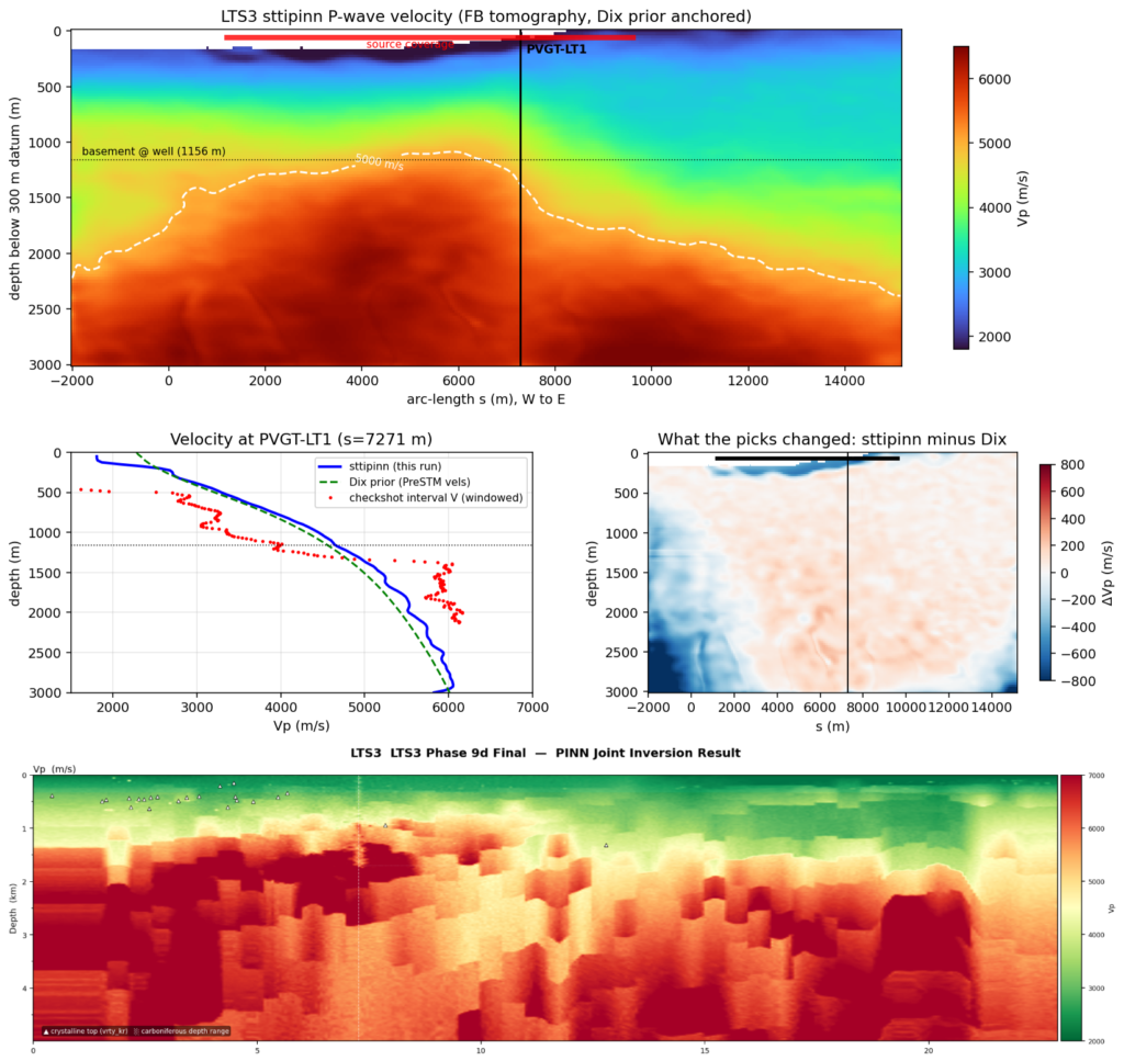
Click on an image to expand
Image Captions
Figure 1: the project as one chain, from reconnaissance and multi physics imaging to a doublet planned under uncertainty and tested against the wells.,Figure 2: Seismic traveltime PINN inversion with first breaks; difference with Dix based velocity model PINN based Joint Inversion reveals structures otherwise invisible to seismic traveltime inversion (all figures and results from preliminiary tests conducted with PDIL).
Methodology
A multi physics reconnaissance to drilling platform (PDIL: Pre-Drill Intelligence Layer) and a research prototype of the WDL: While Drilling Loop (both telemetry regimes, three update methods, the PROCEED / CAUTION / DEFER gate, lag aware steering, replay engine); The main methodological development would be pre-drill and while-drilling uncertainty quantification.
Reconnaissance and framework. Satellite derived lineaments, thermal anomalies, alterations; BGS gravity, aeromagnetic, borehole and heat flow data, and coal mining records will be combined into a 3D structural framework of the fault and the Carboniferous and granite targets.
Imaging. The seismic lines are 1980s stacks; the field records of the four BGS lines will be obtained from the UK Onshore Geophysical Library and reprocessed, and all five lines depth converted with several defensible velocity models. The MT data, raw 1 kHz time series mostly recorded in simultaneous pairs, will be processed with remote reference methods, then analysed for dimensionality and inverted for resistivity, which is sensitive to fault zones and saline fluids, working with BGS within its regional conductivity model of Britain (Hübert et al., 2025). Gravity and magnetic data constrain the basement and test the two granite models.
Joint imaging with uncertainty. The data will be combined in a coupled joint inversion (Moorkamp et al., 2011) using candidate’s self-developed framework. Instead of one model, the candidate will deliver an ensemble, weighting competing velocity models and fault geometries by how well they explain all the data, so that the spread between defensible models becomes a stated uncertainty on fault dip and granite depth.
Fault zones. Permeability and frictional properties of vein fault rocks from outcrop analogues and archived core will be measured in the Durham rock mechanics laboratory, and fluid flow models of the fault zone (Snell et al., 2020) will assess both its productivity and its potential for induced seismicity.
From model to well. A thermal model, calibrated with regional bottom hole temperatures, will convert the subsurface model into temperature at depth. Candidate doublet locations will be scored against the uncertainty, and a value of information analysis will show which additional measurement, such as a hole to test the dip, would most reduce the uncertainty that governs the drilling decision.
Validation. If the doublet is drilled, logs, cuttings and temperature data will update the model and be compared with the predictions; otherwise the test will use data held out of the inversion, such as regional deep boreholes.
Project Timeline
Year 1
Data inventory and quality control; reconnaissance mapping and the 3D structural framework. Seismic data analysis, including pre-stack depth migration plus time to depth conversion of time migrated data, alongside analysis of magnetotelluric, gravity & magnetics (with BGS), customised inversion methods with uncertainty quantification and related scientific programming.
Year 2
Joint inversion with uncertainty quantification. Laboratory measurements on fault rocks. First paper: a multi physics model of the target area with stated uncertainty. Hands on work with Geothermal Wells LLC on well planning.
Year 3
Fault zone flow and stability modelling; thermal model; doublet planning under uncertainty. If drilling proceeds, another placement with Geothermal Wells to acquire and assimilate well data, supporting real time geosteering. Second paper.
Year 3.5
Test of the predictions against the drilled wells or held out boreholes; conference attendance, third paper and write-up of the thesis.
Training
& Skills
The candidate will be trained in uncertainty quantification methods and experimental rock mechanics at Durham and at BGS. Placements with Geothermal Wells will give additional experience in well planning, drilling, geosteering and the commercial and regulatory side of geothermal development.
Generic training will come from the department and the Iapetus cohort programme. The candidate will present at national and international meetings and aim for at least two papers, preparing for careers in the fast growing geothermal and energy-metals/CRM sector.
References & further reading
Gluyas, J.G. et al. (2018). Keeping warm: a review of deep geothermal potential of the UK. Proceedings of the Institution of Mechanical Engineers, Part A, 232(1), 115-126. https://doi.org/10.1177/0957650917749693
Hübert, J. et al. (2025). Developing a new ground electric field model for geomagnetically induced currents in Britain based on long-period magnetotelluric data. Space Weather, 23(8), e2025SW004427. https://doi.org/10.1029/2025SW004427
Kimbell, G.S., Young, B., Millward, D. & Crowley, Q.G. (2010). The North Pennine batholith (Weardale Granite) of northern England: new data on its age and form. Proceedings of the Yorkshire Geological Society, 58, 107-128.
Manning, D.A.C. et al. (2007). A deep geothermal exploration well at Eastgate, Weardale, UK: a novel exploration concept for low-enthalpy resources. Journal of the Geological Society, 164, 371-382.
Monaghan, A.A. et al. (2022). Drilling into mines for heat: geological synthesis of the UK Geoenergy Observatory in Glasgow and implications for mine water heat resources. QJEGH, 55(1), qjegh2021-033.
Moorkamp, M. et al. (2011). A framework for 3-D joint inversion of MT, gravity and seismic refraction data. Geophysical Journal International, 184, 477-493.
Snell, T., De Paola, N., van Hunen, J., Nielsen, S. & Collettini, C. (2020). Modelling fluid flow in complex natural fault zones: implications for natural and human-induced earthquake nucleation. Earth and Planetary Science Letters, 530, 115869. https://doi.org/10.1016/j.epsl.2019.115869
Younger, P.L., Manning, D.A.C., Millward, D., Busby, J.P., Jones, C.R. & Gluyas, J.G. (2016). Geothermal exploration in the Fell Sandstone Formation (Mississippian) beneath the city centre of Newcastle upon Tyne, UK. QJEGH, 49, 350-363. https://doi.org/10.1144/qjegh2016-053
