

IAP-26-129
Where does the carbon go? Tracking river to sea carbon with satellites and AI
British rivers deliver around 1.15 MT of dissolved organic carbon (DOC) to the coast every year. Per unit area this is comparable to the Amazon and higher than most large temperate and Arctic rivers, because Britain combines high rainfall with extensive peat soils (Williamson et al. 2023). Current estimates are based on sampling at the tidal limit and do not yet account for the removal and transformation of DOC in estuaries and coastal seas. DOC concentrations in many northern European rivers have been increasing (‘browning’) due to land-use change, and a wetter, more extreme climate. The coloured fraction of DOC, known as coloured dissolved organic matter (CDOM), strongly absorbs blue light. As CDOM rises it also darkens coastal water, competing with phytoplankton and suspended sediment for the light that seagrass, macroalgae and phytoplankton need, and complicating assessments of water clarity and eutrophication. CDOM is therefore both a tracer of terrestrial carbon and a driver of coastal light climate.
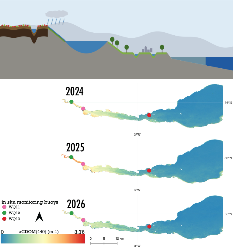
Space agencies now see this as a priority. The CEOS Aquatic Carbon Roadmap and the ocean carbon from space roadmap that fed into it (Brewin et al. 2023) identify the land–ocean interface as a key gap, and call for better satellite retrievals in coastal waters, quantified uncertainties and more in situ data. Remote sensing of DOC along the land-ocean aquatic continuum is advancing quickly but remains limited at the coast (Fichot et al. 2023). Satellite ocean colour can observe CDOM daily, but in optically complex coastal waters current retrievals of CDOM absorption (aCDOM) are unreliable, largely because atmospheric correction errors peak in the blue bands (around 412 nm) where the CDOM signal lies. The supervisory team has recently shown that satellite CDOM can track DOC in coastal Arctic fjords (Aguilar Vega et al. 2026) and that DOC can be retrieved from space across hundreds of lakes (Liu et al. 2024). This PhD project is co-designed with Cefas and the Environment Agency. It will (i) develop a regionally robust, uncertainty characterised aCDOM algorithm for satellite data such as Sentinel-2 and -3, combining optical water types with machine learning. (ii) It will also convert it to DOC using new paired CDOM–DOC measurements. The resulting dataset will be used to (iii) estimate how much terrestrial DOC English rivers deliver to the coast and how this responds to rainfall and river flow. These give Cefas and the EA a new satellite indicator linking catchment management, coastal carbon and water quality, and an evidence base for predicting the impacts of climate change.
Objectives
1. Build a paired dataset of above-water remote sensing reflectance (Rrs), aCDOM, DOC and salinity along UK river-sea gradients.
2. Benchmark published CDOM algorithms per optical water type, then develop an aCDOM retrieval for OLCI/MODIS combining physically based and machine learning approaches, with per-pixel uncertainty.
3. Quantify the algorithm’s sensitivity to different atmospheric correction processors, and select the most operationally robust combination.
4. Establish CDOM-DOC relationships for UK coastal waters and produce satellite DOC with characterised uncertainty.
5. Map coastal DOC in the UK
6. Quantify riverine DOC delivery to the coast and its response to precipitation and river flow
Click on an image to expand
Image Captions
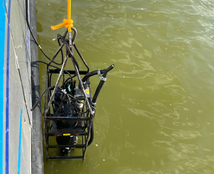
example of a coloured dissolved organic matter from Sentinel-2 data in the Forth estuary,Optics cage deployed during fieldwork in the Black Sea
Methodology
Field and in situ data (Years 1–3). The student will collect above-water radiometry (Rrs) alongside CDOM absorption spectra, DOC and salinity samples on multiple trips on Cefas and EA vessels, including RV Cefas Endeavour and EA inshore Protector vessels, sampling along river-plume salinity gradients. These will be combined with existing EA–Cefas CDOM measurements; existing datasets from LIMNADES, GLORIA and past projects (e.g. NERC GloboLakes) covering estuaries and lakes, which anchor the freshwater end of the continuum. Fieldwork will count toward the Cefas CASE placement.
Algorithm development (Years 1–2). Using the in situ Rrs–aCDOM dataset first, removing atmospheric correction as a source of error, the student will run a round-robin of published algorithms usable with MSI/OLCI/MODIS bands. Performance will be scored per OWT with standard metrics (RMSE, MAE, bias, median absolute percentage difference, type-II regression, retrieval rate) to map where CDOM retrieval is feasible. The best algorithms will be re-tuned per OWT and compared with machine-learning models, and explainable-AI tools will check that models rely on physically meaningful spectral features.
Atmospheric correction, satellite application and uncertainty (Years 2–3). The algorithm will be applied to OLCI and MODIS imagery processed with several atmospheric correction processors (e.g. standard L2, C2RCC, POLYMER, ACOLITE), with cloud, land adjacency and glint pixels masked (e.g. IdePix for OLCI), and validated against match-ups. Per-pixel uncertainty will combine algorithm, OWT-membership and atmospheric correction, so products are fit for trend analysis and for use by Cefas and the EA.
Coastal carbon fluxes, hydrological drivers and light climate (Years 3–3.5). Using the in situ data, the student will establish acdom-DOC relationships and identify where they hold (terrestrially dominated plumes) or break down (marine or autochthonous CDOM). Satellite DOC will then be combined with river-flow records to estimate DOC delivery to the coast from major UK estuaries [e.g. Humber, Thames, Severn, Forth] and compared with EA catchment water quality data.
Project Timeline
Year 1
Literature review, training in radiometry and ocean colour processing, first field campaign, assemble in situ datasets, baseline algorithm comparison
Year 2
Further fieldwork (Cefas placement), AI algorithm development, atmospheric correction , Paper 1 (algorithm)
Year 3
Satellite time-series production and validation, light-climate partitioning, Paper 2, international conference
Year 3.5
Precipitation, river and CDOM analysis, Paper 3, thesis writing, handover of methods to Cefas/EA
Training
& Skills
The student will gain training in field radiometry, CDOM and carbon measurement and analysis, ocean-colour data processing and atmospheric correction, machine learning and uncertainty quantification, and time-series and hydrological analysis. They will join the Earth and Planetary Observation Sciences group at Stirling and AI/remote sensing students at Glasgow, alongside Iapetus cohort training. The Cefas placement and EA fieldwork provide direct experience of how government science underpins marine and water quality policy. Opportunities include ESA/EUMETSAT ocean colour training courses and the Ocean Optics and IOCCG community meetings.
References & further reading
• Nguyen, V.S., Loisel, H., Vantrepotte, V., Mériaux, X. & Tran, D.L. (2024) An empirical algorithm for estimating the absorption of coloured dissolved organic matter from Sentinel-2 (MSI) and Landsat-8 (OLI) observations of coastal waters. Remote Sensing 16, 4061. doi:10.3390/rs16214061
• Mograne, M.A., Jamet, C., Loisel, H. et al. (2019) Evaluation of five atmospheric correction algorithms over French optically-complex waters for the Sentinel-3A OLCI ocean colour sensor. Remote Sensing 11, 668. doi:10.3390/rs11060668
• Spyrakos, E. et al. (2018) Optical types of inland and coastal waters. Limnology and Oceanography 63, 846–870.
• Neil, C., Spyrakos, E., Hunter, P.D. & Tyler, A.N. (2019) A global approach for chlorophyll-a retrieval across optically complex inland waters based on optical water types. Remote Sensing of Environment 229, 159–178.
• Werther, M., Odermatt, D., Simis, S.G.H., … Spyrakos, E. (2022) A Bayesian approach for remote sensing of chlorophyll-a and associated retrieval uncertainty in oligotrophic and mesotrophic lakes. Remote Sensing of Environment 283, 113295.
• Atwood, E.C., Jackson, T., … Spyrakos, E. et al. (2024) Framework for regional to global extension of optical water types for remote sensing of optically complex transitional water bodies. Remote Sensing 16, 3267.
• Lakes_cci (2022) CDOM algorithm development for global inland waters, Technical Note CCN-D-1. ESA Climate Change Initiative.
• Mannino, A., Russ, M.E. & Hooker, S.B. (2008) Algorithm development and validation for satellite-derived distributions of DOC and CDOM in the U.S. Middle Atlantic Bight. J. Geophys. Res. 113, C07051.
• Meyer-Jacob, C. et al. (2019) The browning and re-browning of lakes: divergent lake-water organic carbon trends linked to acid deposition and climate change. Scientific Reports 9, 16676.
