

IAP-26-116
The 30m raised beach conundrum – reconstructing UK sea-level change and land motion over 200,000 years.
A couple of kilometres north of Easington, Durham (UK) lies a raised beach deposit in the exposed cliff ~33 m above modern sea level. Detailed research of the mixed sands, gravels and shells forming the unit indicate an inter-glacial age of 210,000 years BP and a high energy, temperate marine coastal depositional environment (Davies et al. 2009). While the raised beach’s age and interpretation are well constrained, many questions about it remain unresolved. These form the basis for this project, which aims to shed new light on the Quaternary sea-level change and uplift history of NE England.
Question 1: Is there other evidence of the raised beach along the Durham Coast? The observed exposure at Easington raised beach is 15 m wide and 5 m high but oblique photography of this portion of the Durham coastline shows other similar exposures that might be candidates to delineate its lateral extent as well as providing more information about the depositional environment and its age.
Question 2: When was the raised beach deposited during MIS-7? Davies et al. (2009) dated the beach giving ages ranging from 153 ± 17 to 250 ± 30 ka BP. However, greater accuracy of the timing of deposition during the inter-glacial is important to reconstruct its sea-level change and uplift history.
Question 3: Why is Easington raised beach at this elevation now, when other beaches of a similar age are much lower? Paleo-beach deposits of similar age in the south of England and Europe are ~25 m lower than the Easington raised beach (Cohen et al. 2022). Recent hypotheses suggest long-term isostatic uplift in the north of England due to a combination of upland erosion unloading the crust, and a warm layer in the asthenosphere lowering regional viscosity to enhance uplift (Davies et al. 2009). This local signal is thought to explain the elevation difference with southern sites.
An important contributor to uplift that is unaccounted for in this hypothesis is glacial isostatic adjustment (GIA). GIA is the ongoing deformational response of the Earth to past and present changes in the ice sheets. The regional history of GIA is deeply uncertain across the UK prior to 35,000 years ago (Scourse, 2024), and to our knowledge only one GIA reconstruction over multiple glacial cycles that incorporates regional sea-level change has been attempted (De Boer et al. 2014).
Thus, our understanding of the past and present GIA response to regional ice mass changes is both scientifically valuable and societally important because sea-level budgets and projections rely on its accurate reconstruction.
The project will require a synthesis of UK paleo-sea-level observations into a self-consistent database (e.g., Cohen et al. 2022) and field/laboratory studies of exposures along the coast surrounding Easington raised beach. The candidate will work with our CASE partner, Northeast Coastal Observatory, to conduct state-of-the-art 3D drone surveys of this coastal section to enable the execution of high-fidelity digital mapping and analysis. Exposure analysis will require detailed sediment logging and biological/geochemical analysis.
Models of GIA will then be run to determine sea-level change and GIA-uplift histories over the last four glacial cycles using ice model reconstructions from De Boer et al. (2014). Adjustments to the model will be made based on validation with the database to refine the ice mass loss history, (particularly the British & Irish ice sheet and Scandinavian ice sheet) and/or earth-structure.
Click on an image to expand
Image Captions
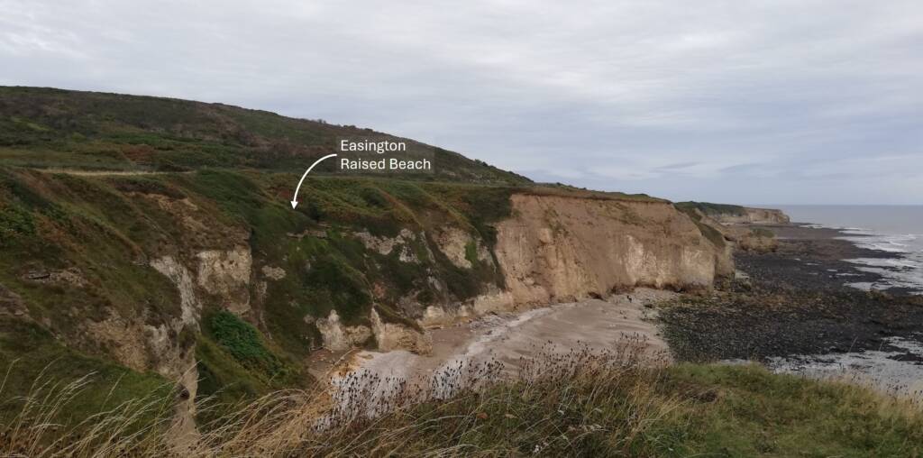
View of Shippersea Bay looking north along the Durham Coast. Easington Raised Beach is tucked out of sight behind greener vegetated cliff extending down to shoreline – see arrow. Beacon Hill, a reef dolomite, rises behind the foreground cliffs, and the Hartlepool-Sunderland trainline runs in a cutting between the two. Image credit: L.P. Jackson
Methodology
Evaluate existing literature and develop a UK interglacial sea-level database (primarily landform evidence) that covers the last 400,000 years, starting from Cohen et al. (2022).
Conduct state-of-the-art 3D drone surveys of Easington raised beach and local coastal area (primarily cliff exposures) to conduct digital mapping and analysis. Conduct targeted, in-person analysis of candidate exposures for detailed sediment logging and biological/geochemical analysis to establish depositional environments and their age using Optically Stimulated Luminescence dating.
Run models of glacial isostatic adjustment and associated sea-level change in response to the deglaciation of global ice sheets using ice sheet reconstructions (e.g. De Boer et al. 2014; Gowan et al. 2021; Clark et al. 2022; Scourse, 2024), and experiment with earth properties and timing of ice-mass changes.
Validate model results against sea-level data across different time periods (e.g. late Pleistocene, MIS-5e, MIS-7) and assess regional uplift/sea-level history over multiple glacial cycles to assess relative role of GIA in modern elevation distribution of interglacial raised beach deposits.
Project Timeline
Year 1
Induction process
Training in field methods (e.g. site levelling, sediment logging) and lab methods (e.g. sample preparation/analysis), data-handling, sea-level databases, and GIA modelling from supervisory team.
Conduct literature review and develop UK interglacial sea-level database.
First CASE partner placement (2-3 months) to conduct and analyse 3D drone surveys of Durham coast.
Conduct field study of candidate exposures (detailed sediment logging, biological/geochemical sampling and analysis including dating)
Submit year 1 progress report
Attend Sea Level & Coastal Change meeting 2028 (Univ. Gloucester)
Year 2
Continue laboratory analyses of exposure samples (biological/geochemical sampling and analysis including dating).
Complete field/lab analyses and synthesise into draft paper for journal.
Run models of glacial isostatic adjustment using a suite of input parameters (earth structure and state-of-the-art multi-glacial ice model) to obtain a suite of sea-level predictions.
Submit year 2 progress report
Year 3
Deliver year 3 progress update presentation
Second CASE partner placement (2-3 months) to synthesise coastal datasets and provide expert support to NE Coastal Observatory on Durham coast management options.
Test the suite of parameterised models with adjustments to the ice model to refine sea-level and uplift reconstructions by using databases as means of validation over different time periods (e.g., late Pleistocene, MIS-5e, MIS-7).
Develop conceptual model that reconciles Quaternary depositional history of the Durham coastline with revised, modelled sea-level/uplift histories. Synthesise into draft paper for journal.
Year 3.5
Finalise thesis chapters
Thesis submission
Training
& Skills
The student will receive both generic and bespoke training in site surveying, remote drone usage, lab-based biological and chemical analyses, and GIA modelling from the supervision team. This will include software training in Linux and associated scripting; Matlab, Python or R.
Additional numerical modelling and data-manipulation skills will be provided at national/international workshops with these foci (e.g., GIA Training School).
Broader transferable skills will be developed through various training events at Durham University offered by IAPETUS (e.g., communicating science, thesis writing, writing for publication, presentation skills).
References & further reading
Clark, C.D., Ely, J.C., Hindmarsh, R.C., Bradley, S., Ignéczi, A., Fabel, D., Ó Cofaigh, C., Chiverrell, R.C., Scourse, J., Benetti, S. and Bradwell, T., 2022. Growth and retreat of the last British–Irish Ice Sheet, 31 000 to 15 000 years ago: the BRITICE‐CHRONO reconstruction. Boreas, 51(4), pp.699-758.
Cohen, K.M., Cartelle, V., Barnett, R., Busschers, F.S. and Barlow, N.L., 2022. Last Interglacial sea-level data points from Northwest Europe. Earth System Science Data, 14(6), pp.2895-2937.
Davies, B.J., Bridgland, D.R., Roberts, D.H., Cofaigh, C.Ó., Pawley, S.M., Candy, I., Demarchi, B., Penkman, K.E. and Austin, W.E., 2009. The age and stratigraphic context of the Easington Raised Beach, County Durham, UK. Proceedings of the Geologists’ Association, 120(4), pp.183-198.
De Boer, B., Stocchi, P. and Van De Wal, R.S.W., 2014. A fully coupled 3-D ice-sheet–sea-level model: algorithm and applications. Geoscientific Model Development, 7(5), pp.2141-2156.
Gowan, E.J., Zhang, X., Khosravi, S., Rovere, A., Stocchi, P., Hughes, A.L., Gyllencreutz, R., Mangerud, J., Svendsen, J.I. and Lohmann, G., 2021. A new global ice sheet reconstruction for the past 80 000 years. Nature Communications, 12(1), p.1199.
Scourse, J.D., 2024. The timing and magnitude of the British–Irish Ice Sheet between Marine Isotope Stages 5d and 2: implications for glacio‐isostatic adjustment, high relative sea levels and ‘giant erratic’emplacement. Journal of Quaternary Science, 39(4), pp.505-514.
