IAP-25-043
Tracking and tracing contaminated sediment in historic mining headwater catchments
The aim of this project is to better understand the delivery of contaminated mine sediment from disturbed headwater catchments over historical, contemporary and future timescales (under climate change scenarios). The approach focuses on headwater source areas which critically control downstream impacts on the river network by regulating sediment, nutrient and pollutant transfer; controlling runoff and flood transmission; providing habitats for endangered aquatic and terrestrial organisms; supporting traditional agroecosystems; and determining connectivity/discontinuity at the catchment-scale. The hydroclimatic regime of headwater catchments, tends to be spatially and temporally very variable, promoting extreme flood flows which result in the episodic transfer of sediment and contaminants through the sediment cascade into downstream water bodies and lakes.
Such flows are predicted to increase in severity under future climate change scenarios and have direct impacts on the redistribution of mining waste and associated ecosystem services. Recent work by (Baynes et al., 2023) has demonstrated that using a multiple catchment approach with combined topographic analysis and detailed mapping of channel and sediment source morphological zones, general predictions of extreme flood impacts can be made. This project will use this approach to investigate sediment delivery of contaminated mining waste in environmentally-critical headwater catchments in the English Lake District.
The key research questions are:
1) How do the fundamental geomorphological characteristics of headwater catchments control sediment transfer during extreme hydrological events?
2) How does the intensity and type of mining impact the spatial and temporal release and transfer of sediment from contaminated headwaters over multiple timescales?
3) Can historical (documentary and field) records of previous extreme events in headwater catchments and downstream lake basins define past climate trends and be used as a basis for modelling future climate impacts?
4) How effective are contaminants as ‘natural tracers’ for identifying transfer pathways and sediment continuity in the upland source-to-sink sediment cascade?
Click on an image to expand
Image Captions
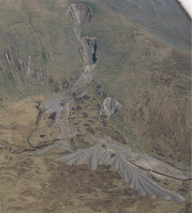
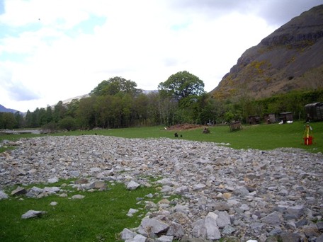
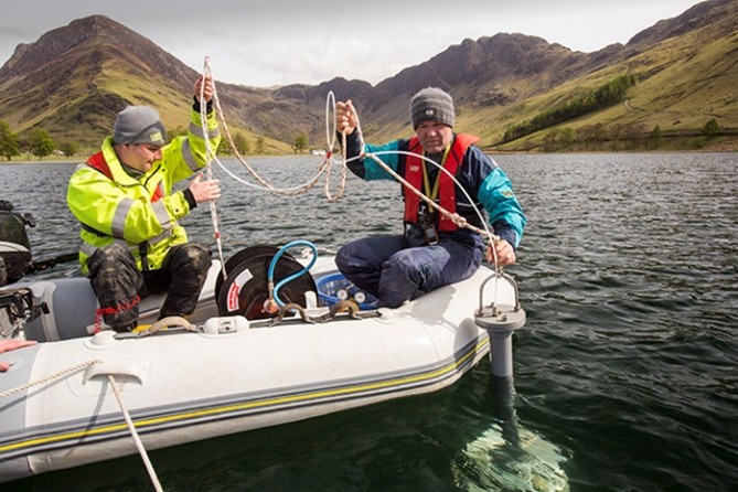
Green Side upper mine, Glenridding, Ullswater.,Storm Desmond flood sediment Derwent catchment.,Lake coring in Buttermere.
Methodology
The project has scope to study four headwater-lake catchments (i) Greenside Mine – Glenridding – Ullswater catchment; (ii) River Derwent and Bassenthwaite Lake Special Area of Conservation (iii) Honister – Gatesgarthdale – Buttermere catchment; and (iv) Coniston Coppermines – Church Beck – Coniston Water system. These catchments satisfy the requirements of the key research questions and make use of a rich data archive held at the host institution. Importantly, the four catchments all consist of coupled headwater-lake systems, were internationally important areas for mining activities (Pb, Cu & Slate), and represent a range of distinct mining settings/operations. The Ullswater area was heavily impacted by extensive lead (Pb) mining; the Derwent forms part of a Special Area of Conservation (SAC) with multiple mine inputs; Coniston was impacted by extensive copper (Cu) extraction, while Buttermere had only small-scale metal mining trials (Pb and Cu) but was the site of large-scale slate quarrying. The final scope of the project and range of field sites is open to input by the student depending on their experience, specific interests and ideas.
The project methodology is mirrored at the four sites and consists of four integrated work packages:
1. A detailed geomorphological and topographic analysis to establish the contemporary sediment budget of the headwater catchment and set-up a HEC-RAS modelling framework to examine the local flood hydrology.
2. An archival and geomorphological analysis of each catchment to establish the chronology of mining (sediment production) and record of historical flood events (sediment transfer).
3. Lake coring to determine the downstream sedimentary record of mining, flooding and land-use change in the headwater catchment.
4. Landscape evolution modelling (CAESAR-Lisflood – coupled 2D hydrodynamic flow and geomorphic model) to simulate erosion and deposition over contemporary, historical and future timescales to understand how the current sediment system will respond to predicted future climate and catchment changes.
A key strength of the project is that data for work packages 1-3 is already available in the existing data archive for Ullswater, Bassenthwaite and Buttermere sites, so new primary data collection will be focussed on the Coniston and River Derwent headwater catchments.
The outputs from the project will greatly increase knowledge of how mining activities impact the upland sediment cascade; provide a critical test of the use of natural tracers to track geomorphic change in active headwaters; and demonstrate how headwater rivers will respond to changing climate and environmental conditions. This will provide direct benefits to stakeholders who seek to manage river pollution, maintain ecosystem services and assess the future viability of river rewilding and flood management schemes.
Project Timeline
Year 1
Literature review and project design
Consolidation and compilation of existing data archive in a common framework
Complete detailed geomorphological / topographic analysis and contemporary sediment budget
Start fieldwork in Derwent and Coniston headwater catchments
Compile archive of chronology of mining and record of historical flood events.
Set up catchment GIS and HEC-RAS modelling framework
Complete lake coring of Coniston Water
Year 2
Complete analysis of Coniston Water lake cores – lab work
Complete fieldwork in the Coniston and Derwent headwater catchments
Set up geomorphological / landscape evolution model (CAESAR-Lisflood) for the study catchments
Drafting of paper outlines and initial paper I
Year 3
Complete geomorphological / landscape evolution modelling (CAESAR-Lisflood)
Submission of first paper for publication
Complete drafts of two other papers (II & III) and begin compilation of final thesis
Year 3.5
Complete final thesis submission of papers for publication
Training
& Skills
A Training Needs Analysis (TNA) will be conducted to evaluate the student’s skills and design technical training bespoke to the project but also to enhance the general skills portfolio. Key skills will include fieldwork training / risk assessment; GIS & quantitative analysis of DEMs; analysis of large data sets; physical and geochemical laboratory analysis; and hydrologic and geomorphological modelling techniques. Full advantage will be taken of IAPETUS training opportunities e.g. modules in Introduction to modelling in Python and Advanced statistics in R. The thesis will be completed as a series of three publications. The student will attend Department, University and IAPETUS training courses to enhance skills in scientific writing with additional bespoke support from the supervisory team. The student will also be expected to take an active part in the research culture of the Department and IAPETUS Programme attending Department seminars / workshops and The IAPETUS Residential Research Training Week and annual conference. The student will also be encouraged to attend national and international conferences top present their research and network with the wider scientific community.
References & further reading
Baynes, E. R. C., Kincey, M. E., & Warburton, J. (2023). Extreme flood sediment production and export controlled by reach-scale morphology. Geophysical Research Letters, 50, e2023GL103042. https://doi.org/10.1029/2023GL103042
Chiverrell, R.C., Sear, D.A., Warburton, J., Macdonald, N., Schillereff, D.N., Dearing, J.A., Croudace, I.W., Brown, J. & Bradley, J. 2019. Using lake sediment archives to improve understanding of flood magnitude and frequency: recent extreme flooding in northwest UK. Earth Surface Processes and Landforms. https://doi.org/10.1002/esp.4650
Joyce, H.M., Hardy, R.J., Warburton, J. & Large, A.R.G. 2018. Sediment continuity through the upland sediment cascade: geomorphic response of an upland river to an extreme flood event. Geomorphology 317: 45-61.
Kincey, M., Warburton, J. 2025. Anthropogenic legacy sediment budgets in heavily disturbed historical mining catchments. Geomorphology, 470, Article 109518. https://doi.org/10.1016/j.geomorph.2024.109518
Kincey, M.E., Warburton, J. & Brewer, P. 2018. Contaminated sediment flux from eroding abandoned historical metal mines: Spatial and temporal variability in geomorphological drivers. Geomorphology 319: 199-215.