IAP-25-122
Sundaland Reimagined: The Reconstruction of a Lost Cenozoic Continent
The Sunda Shelf, also known as Sundaland, was formed through the accretion of crustal fragments that rifted from the Gondwanan margin beginning in the Triassic. Since the start of the Cenozoic, around 65 million years ago, it has remained a relatively stable continental block, despite its position at a tectonic triple junction where the Eurasian Plate intersects with the northward-moving India–Australia Plate and the westward-moving Philippine Sea Plate. Now expressed as a broad, submerged shallow shelf, Sundaland has been repeatedly exposed and submerged throughout the Cenozoic. These changes were driven by fluctuations in global sea level and by tectonic uplift and rifting. As a result, the region has experienced regular re-routing of large river systems (e.g., Cheng and Feidi, 2025), the rise and erosion of mountain belts (e.g., Gough and Webb, 2024), and the formation of intermittent deep basins (e.g., Hall, 2013). Each of these features had the potential to strongly influence the movement of species, from birds to hominids, across the region during the Cenozoic. This project takes an interdisciplinary approach to address the absence of comprehensive palaeogeographic reconstructions of the Sunda Shelf in Southeast Asia throughout the Cenozoic. By combining existing geological data, new samples, and updated tectonic reconstructions, the project will reconstruct the region’s tectonic evolution and assess its influence on landscape change and palaeoenvironments.
The project aims to produce new, detailed and data-driven palaeogeographic reconstructions of the Sunda Shelf for every 1 million years for the last 65 million years. While previous studies have addressed individual elements of its tectonic and environmental history, such as maps based on river systems or the distribution of vegetation, there is no integrated regional framework. The main limitation is the absence of models that combine geological samples, tectonic reconstructions, and remotely sensed datasets at an appropriate scale.
To bridge this gap, the project will utilise an existing database of geological samples, including light and heavy mineral assemblages, U–Pb zircon ages, and biostratigraphic data, further supplemented by literature-derived records. Where gaps in the geospatial distribution of these data are identified, they will be used to plan a targeted field season in the Sundaland region. Samples collected will increase data density in these areas and will be analysed for light and heavy minerals, U–Pb zircon ages, and, where appropriate, biostratigraphy. These updated datasets will be used to produce detailed palaeogeographic maps of the Sunda Shelf throughout the Cenozoic using the PALEOMAP PaleoAtlas plugin for GPlates using multiple proxies. In parallel, existing tectonic reconstructions will be evaluated and refined in GPlates to assess how tectonic processes have shaped regional evolution. The combined reconstructions will then be used to examine how basin development and tectonic activity may have influenced species dispersal between Asia and Australasia.
Click on an image to expand
Image Captions
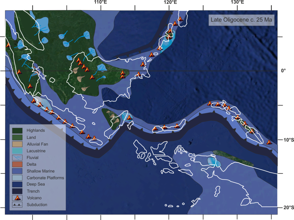
Example of a simplified Late Oligocene palaeogeography of Sundaland based on provenance data
Methodology
Database Compilation
Existing information will be collated from published literature, previous theses based in the Sundaland region, and governmental sources. These datasets will be standardised into a structured database capturing geological attributes such as lithology, age indicators (e.g. palynology, foraminifera), and geographic location, alongside provenance data including U–Pb zircon ages and heavy mineral assemblages.
Tectonic Framework Integration
Current tectonic reconstructions and models for the Sunda Shelf will be reviewed and analysed to identify major tectonic events and crustal reconfigurations that shaped the region’s geological evolution.
Fieldwork and Sedimentary Provenance
A field season in the Sundaland region will target areas with sparse data. Samples collected during this trip will be processed for sediment provenance analysis, including thin sections for petrographic analysis of light minerals, mineral separation for heavy mineral analysis, and further extraction of detrital zircon for U-Pb age dating. These methods are chosen to best integrate into the existing provenance database that these integrated palaeogeographies will be built from.
Palaeogeographic Reconstruction
The geological dataset and tectonic models will be combined to reconstruct past environments and landforms across the Sunda Shelf. Reconstructions will use ArcGIS and the PALEOMAP PaleoAtlas plugin for GPlates to produce 1 Ma interval time slices spanning the last 65 million years.
Biogeographic Integration
Documented evolutionary and migration events across Sundaland will be plotted against the palaeogeographic reconstructions to assess how changing landscapes may have influenced animal and hominin dispersal in the region. This will be achieved through collaboration with Dr Kenneth Rijsdijk of the University of Amsterdam, integrating the palaeogeographies with the R package Temporal Altitudinal Biogeographic Shifts (tabs).
Project Timeline
Year 1
In the first year, the focus will be on organising existing information into a consolidated and comprehensive database. This will involve integrating data from published literature as well as integrating information from previously collated databases. Alongside the database development, a thorough review of literature on regional tectonics, sedimentary systems, and their implications for biodiversity will be undertaken. During this period, training will also begin in ArcGIS and GPlates, as well as core academic skills such as literature review writing, presentation skills, and research dissemination. Once the data has been assembled, it will be analysed spatially in ArcGIS to assess data coverage and enable the extraction of information by Cenozoic Period and by geographic region.
Year 2
The maps produced from the database will be used to plan a field expedition across Sundaland, lasting approximately 30 days and targeting areas with limited existing data. The expedition will address two key goals. First, it will focus on regions where provenance information is sparse, in order to build a more complete picture of past environments. Samples collected will be analysed for light minerals, heavy minerals, and U–Pb zircon ages, complemented by field-based sedimentary data such as logs, panels, and palaeocurrent measurements. Second, the fieldwork will give the PhD researcher first-hand familiarity with the geological character of the Sundaland terrane, helping to inform the development of more accurate palaeogeographic reconstructions. A substantial portion of the year will be dedicated to sample preparation and analysis. Findings and insights from this work will be presented to the wider community at a national conference (e.g. BSRG).
Year 3
In the final year of the project, the focus will shift to integrating the geological and provenance data through time using ArcGIS and reconstructing realistic palaeogeographies in GPlates with the PALEOMAP PaleoAtlas plugin. These reconstructions will be informed by evidence of sedimentation patterns and sediment transport pathways to show how environments evolved across the Sunda Shelf. Once the palaeogeographies are complete, documented dispersal routes of species, particularly across the Asia–Australasia gateway, will be mapped onto them to assess the extent to which geological evolution and landscape configuration influenced movement. The resulting models and interpretations will be presented at a major international conference such as EGU.
Year 3.5
The final 6 months of the project will focus on finalising the writing of the thesis, as well as finishing off any papers in progress.
Training
& Skills
Training in constructing palaeogeographic models and use of the SEARG database will be provided by the supervisory team. Training in use of GPlates and the production of tectonic reconstructions can be provided by Earth Byte (the team behind GPlates) through a comprehensive online workshop. Additional training workshops may be attended by the student where appropriate funding can be sourced. Finally, general training in thesis writing, research communication, and career management can be provided by postgraduate researcher development program within the Research Futures Academy, which has training on everything from writing skills to using Machine Learning in your research.
References & further reading
Cheng, S. and Faidi, M.A., 2025. Palaeodrainages of the Sunda Shelf detailed in new maps. Journal of Palaeogeography, 14(1), pp.186-202.
Hall, R., 2013. The palaeogeography of Sundaland and Wallacea since the Late Jurassic. Journal of Limnology, 72.
Metcalfe, I., 2011. Tectonic framework and Phanerozoic evolution of Sundaland. Gondwana Research, 19(1), pp.3-21.
Gilbertson, D., McLaren, S., Stephens, M., Hunt, C.O., Rose, J., Grattan, J.P. and Mani Banda, R., 2017. The changing landscape of sundaland: The geography of coastal Northern Borneo from the last Glacial Maximum to the present. Archaeological investigations in the Niah Caves, pp.129-148.