IAP-25-031
Source or sink? The roles of glacier melt and sediment transport for the carbon budget of the Greenland Ice Sheet
Approximately 80% of Greenland is covered by a massive ice sheet that holds around 7% of the Earth’s freshwater. The Greenland Ice Sheet sits above vast deposits of carbon-containing sediments, as well as holding significant amounts of organic carbon in ice, which is released into the surrounding environment through melting and iceberg calving where outlet glaciers reach the sea. When glaciers melt, the underlying sediment, which is rich in nutrients and minerals that represents various forms of organic matter, are washed into downstream fjords and from there into the outlying Atlantic Ocean via an underwater flow of meltwater. Despite their importance, Greenland’s fjords remain underrepresented in global carbon budgets, even though accelerated melt and retreat of the Ice Sheet is altering these ecosystems through increased freshwater discharge, iceberg calving, and the flux of sediments and other materials into fjord systems.
When sediment-laden meltwater enters a fjord, it forms a turbid plume that helps drive the circulation of water masses between fresh meltwater from the glacier and saline water from the ocean. Through this process, fine sediment particles remain suspended in the water and can travel far into the fjord and even onto the continental shelf, while coarser materials settle near the glacier front. Therefore, fjords act as natural sediment traps, preserving histories of glacial-landscape erosion within semi-enclosed basins, as well as representing a globally important but currently overlooked carbon sink.
To trace the origin of sediment and associated organic matter, geoscientists use biomarkers—molecular indicators that provide information about the origin, composition, and age of the organic material, whether this be from terrestrial vegetation, microbial communities on, in and under the ice, or marine sources. It is important to understand the composition of the dissolved and particulate carbon emanating from the glaciers, as this can be used to determine whether the carbon has a positive, neutral, or negative impact on the climate as it is released from source (glacier) to sea. Current estimates of the quantity of sediment exported from Greenland potentially exceeds 1000 million tonnes per year but the sparsity of data from around Greenland results in both the marine sediment and carbon budgets being poorly constrained.
This PhD studentship seeks to characterise the nature of the sediment transport from glacier runoff, and to what extent this exported sediment represents a carbon source or sink. Focusing on Kangerdlugssuaq Glacier in Southeast Greenland and its downstream fjord—one of the largest and most dynamic glacier systems of the Greenland Ice Sheet—the student will investigate the glaciological drivers controlling the organic carbon dynamics within the fjord as well as the larger Northwest Atlantic Ocean. Through a multidisciplinary approach that combines glaciology, sedimentology, biogeochemistry, and geomorphology, the student will:
1 – Investigate the quantity and pathways of meltwater discharge from Kangerdlugssuaq Glacier, using hydrological modelling approaches;
2 – Monitor sediment dynamics linked to the hydrologic outflow from glacier meltwater discharge, through satellite remote sensing of meltwater plumes at its terminus;
3 – Quantify and determine the composition of the carbon, through analysis of sediment cores obtained from the Kangerdlugssuaq Fjord; and
4 – Establish the links between glacier meltwater discharge, sediment dynamics, and its organic carbon properties to facilitate creation of a first-order sediment and carbon budget for Greenland.
Ultimately, the student will produce a valuable dataset that determines to what extent Kangerdlugssuaq is a net carbon sink or source, and what role it plays for long-term climate regulation.
Though not dependent on its success, this studentship will run alongside two major field-based projects operating in and around the Kangerdlugssuaq Trough. The first project, KANG-GLAC–led by co-supervisors Hogan and O’Cofaigh–collected marine sediment cores at the trough and inner shelf to reveal how the ice sheet has evolved over the last 11,700 years, as past analogues for how ice-ocean-marine ecosystem scenarios are analogues for future warming projections. The second project, ÆGIR—led by collaborators at the University of Barcelona—aims to understand how ocean currents, seafloor topography, and glacial meltwater interact in Southeastern Greenland to influence glacier stability and wider ocean circulation patterns. As part of ÆGIR, two research cruises will collect water and sediment samples across the Kangerdlugssuaq Trough, which will be subsequently processed to provide biogeochemical compositions of investigated water fluxes. The studentship therefore has synergies with the goals of both KANG-GLAC and ÆGIR, whilst also benefiting from the collaborative and supportive environment of two cutting-edge projects. Further collaborative opportunities within the two projects’ umbrellas may be possible.
Click on an image to expand
Image Captions
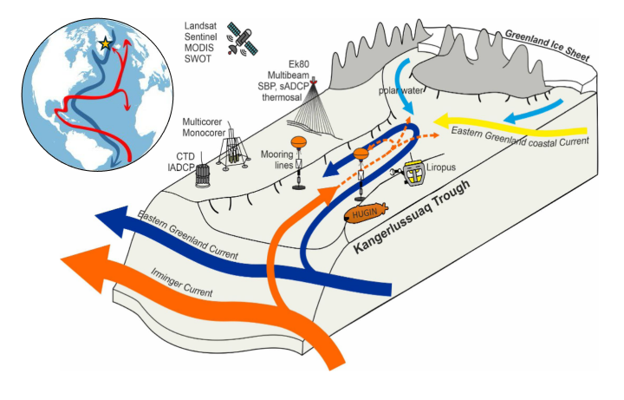
Conceptual schematic of inflows and outflows in the Kangerlussuaq Trough, Southeastern Greenland (starred in inset). Cold, fresh meltwaters enter the fjord from the Greenland Ice Sheet, bringing with it entrained sediment from inland (light blue arrows). Ocean currents (dark blue, red arrows) enter the fjord from its mouth and drive circulation within the fjord. Additional fieldwork activities and deployments from the KANG-GLAC and ÆGIR projects run alongside the timeline of the PhD project, providing complementary measurements and numerous opportunities for collaboration.
Methodology
This project leverages a unique but effective combination of remote sensing, glaciological modelling, and sediment / carbon analysis. Working with supervisors Young and Clason, the student will apply remote sensing algorithms in a big data framework (e.g. Lea 2018, Colosio et al. 2021) to determine the amount of ice discharged from Kangerdlugssuaq Glacier into the fjord, as either meltwater, or as iceberg calving. The pathway of meltwater often travels first from the surface to the bed of the glacier by intersecting crevasses and moulins (Clason et al., 2015), before then being routed to and through subglacial river networks to the glacier terminus. Through calculating the total amount of meltwater discharged from the glacier, the student can then obtain a first-order estimate of the amount of sediment discharged and deposited in the outlying fjord (Andreasen et al. 2024). The student will have the opportunity to analyse sediment cores collected in the Kangerdlugssuaq fjord and inner shelf, to reconstruct glacial dynamics over the recent past (~ the last 150 years). Samples from these cores will be used to quantify organic carbon export and burial through the application of bulk elemental analysis and the development of high resolution age models. The composition and source of the carbon will be explored using stable isotope, ramped thermal and biomarker techniques. When combined with the glacial discharge data these approaches will allow us to constrain the proportion of carbon originating from the glacier (as opposed to other sources), and whether the composition of the carbon results in the Kangerdlugssuaq system being a net-source or sink of carbon in the North Atlantic.
Geophysical data and laboratory analysis underpins all stages of the project. To determine the amount of ice discharged, the student will leverage the Google Earth Engine Digitisation Tool (GEEDiT; Lea 2018), enabling rapid analysis of full-resolution optical satellite imagery to reconstruct a time series of glacier terminus positions. Concurrently, the student will also leverage models of glacier melt and meltwater transport (e.g. Clason et al. 2015) to measure the amount of ice mass lost through the melting of ice and the proportion of this meltwater reaching the bed of the glacier where it can interact with sediment stores. Sedimentological analysis of cores will be undertaken using high resolution core scanning approaches including XRF and CT scanning. A range of analytical approaches will be used, including bulk elemental and ramped thermal techniques to quantify the amount and reactivity of the carbon (Smeaton and Austin, 2022), stable isotopes, radionuclide dating (210Pb, 137Cs, 241Am), radiocarbon and biomarkers such as IP25 to understand the age, source and composition of the carbon.
Project Timeline
Year 1
Develop familiarity in geospatial analysis and remote sensing using the Google Earth Engine, and Python coding platforms. With supervisor Young, apply GEEDiT to map the change in terminus positions through time, obtaining time-varying estimates of glacier ice discharge through calving. With supervisors Clason and Young, implement fundamental models of ice melt driven by Holocene climate records to reconstruct the past 150 years of surface melt, obtaining estimates of glacier ice discharge through melting. With supervisor Clason, model surface-to-bed meltwater routing to determine the source of meltwater. Apply and, if accepted, attend one or more summer schools in glaciology (e.g. Karthaus, McCarthy, GRISO) and/or marine sedimentology and geochemical analysis (e.g. BOSCORF, Southampton or Radiocarbon training, Oxford or MARUM, Bremen)
Year 2
With supervisor Smeaton, apply transfer functions to calculate the amount of sediment discharged from the glacier. The student will undertake biogeochemical measurements and develop chronologies using gamma spectrometry of existing sediment cores obtained from the KANG/GLAC project. If opportunity allows, potential ship-based fieldwork on board R/V Odón de Buen (with R/V Sarmiento de Gamboa as an alternative platform) during Autumn 2027. Present outcomes at national conferences in glaciology and/or oceanography.
Year 3
With supervisor Smeaton, continue analysis of the cores to constrain the reactivity, source and lateral transport times through the application of advanced ramped thermal radiocarbon and compound specific radiocarbon (CSRA) techniques, in collaboration with the NERC National Environmental Isotope Facility in East Kilbride. Optional: Examine the fjord-specific oceanography as an alternative and potentially more physically-based method to calculate sediment transport and deposition through fjords and into the continental shelf. Present outcomes at an international conference (e.g. European Geosciences Union). Draft papers, plan and begin writing thesis.
Year 3.5
Write up and submit thesis. Finalise manuscripts for publication. Attend an international conference.
Training
& Skills
Techniques in geophysical data analysis—namely remote sensing and numerical modelling—and sediment analysis techniques will form the core of this project. Geospatial analysis will also be used to visualise and present results. Development of these skills will be facilitated through in-house expertise in St Andrews and Durham, via IAPETUS2 and NERC researcher training events, and via internationally recognised summer schools, of which several that align with the project have been identified.
Further training in key transferable skills is available through the International Education and Lifelong Learning Institute (IELLI) at the University of St Andrews, which provides learning and teaching support through combining educational development, pedagogical workshops, courses in oral and written communication, and opportunities for media and public engagement. The student will also benefit from cross-disciplinary training as well as the opportunity for an optional 3-month policy secondment, both provided as part of the IAPETUS DTP.
This PhD runs alongside the Spanish Government-funded ÆGIR project and the NERC-funded KANG-GLAC project on complementary themes. Therefore, the student will benefit from the experience of working as part of two large international teams spanning many institutions, thereby building a sizeable professional network. Although the PhD project is not dependent on fieldwork, there is the opportunity to participate in ship-based fieldwork on board the R/V Odón de Buen, which will investigate the Kangerlugssuaq Trough and shelf during Autumns 2027 and 2028.
The student will be encouraged to attend and present their work at national and international conferences throughout the course of their PhD research, in addition to presenting and discussing their work in seminars at St Andrews and collaborating institutions. With guidance from their supervisory team, the student is also encouraged to apply for small grants, which will allow them to gain experience with writing funding proposals.
References & further reading
C.S. Andreasen et al. (2024) Sediment discharge from Greenland’s marine-terminating glaciers is linked with surface melt. Nature Communications, 15(1332). https://doi.org/10.1038/s41467-024-45694-1
C.C. Clason et al. (2015) Modelling the transfer of supraglacial meltwater to the bed of Leverett Glacier, Southwest Greenland. The Cryosphere, 9:123-128. https://doi.org/10.5194/tc-9-123-2015
P. Colosio et al. (2021) Surface melting over the Greenland ice sheet derived from enhanced resolution passive microwave brightness temperatures (1979–2019). The Cryosphere, 15:2623-2646. https://doi.org/10.5194/tc-15-2623-2021
J.M. Lea (2018) The Google Earth Engine Digitisation Tool (GEEDiT) and the Margin change Quantification Tool (MaQiT) – simple tools for the rapid mapping and quantification of changing Earth surface margins. Earth Surface Dynamics, 6:551-561. https://doi.org/10.5194/esurf-6-551-2018