

IAP-26-056
Scalable and transferable monitoring of carbon-rich ecosystems: integrating UAV and satellite remote sensing
Scotland’s carbon-rich ecosystems are undergoing rapid and widespread change as a result of climate-driven shifts in vegetation composition and ecosystem functioning, large-scale peatland restoration, natural woodland regeneration and saltmarsh restoration. These habitats play a critical role in carbon storage, biodiversity conservation, water regulation, and climate change mitigation, making their effective monitoring important for evaluating the success of Nature-Based Solutions and informing future land management decisions.
Monitoring ecosystem change requires information on a wide range of ecological indicators, including vegetation composition, habitat condition, biomass, hydrological status, erosion processes, and rates of ecosystem recovery. Traditionally, such monitoring has relied on field surveys, which provide detailed ecological information but are expensive, labour-intensive, and can be impractical to implement at regional or national scales.
Satellite remote sensing offers an attractive solution by providing frequent observations, national coverage, and long-term environmental records. However, the spatial resolution of most satellite sensors is often insufficient to capture the fine-scale ecological heterogeneity that characterises many Scottish landscapes. Peatland erosion features, saltmarsh creek systems, vegetation mosaics, small restoration interventions, and woodland structural variability may occur at scales substantially smaller than what can be observed by satellites. As a result, these observations alone may fail to detect important ecological changes or incorrectly represent underlying ecosystem processes.
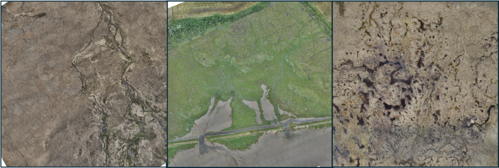
Recent studies have demonstrated the potential of high-resolution unmanned aerial vehicle (UAV) observations to bridge this scale gap by providing detailed measurements of vegetation structure, habitat condition, ecosystem recovery, and landscape processes (Figure 1). These observations can be used to train, calibrate, and validate satellite-based monitoring systems, creating the potential for robust national-scale environmental assessment. Despite considerable progress, questions remain regarding effective sampling design – how many UAV sites are required to develop reliable monitoring systems, how UAV training sites should be distributed across landscapes, and transferability – whether models developed in a limited number of locations can work successfully across regions and ecosystem types.
At the same time, a new generation of Earth Observation Foundation Models offers the possibility of learning general representations from vast satellite archives, potentially reducing the amount of UAV training data required for ecosystem monitoring. However, these are largely trained on cropland, built-up areas and generic land covers and performance remains largely untested within Scottish carbon-rich ecosystems. Understanding how foundation models, conventional machine learning approaches, and UAV observations can be combined to deliver transferable and cost-effective monitoring systems represents a critical challenge for the future of environmental monitoring and Nature-Based Solutions assessment.
This project will address three main challenges:
Component 1: Bridging the scale gap between UAV and satellite observations. A key challenge is how best to use ground and UAV-derived measurements of ecosystem change to improve satellite-based monitoring systems for carbon-rich Scottish ecosystems.
Component 2: Determining the UAV data requirements for scalable ecosystem monitoring. Collecting UAV data is expensive and time consuming so a major challenge is determining how much UAV training data is needed and how it should be spatially and temporally distributed, and how those requirements change between conventional machine learning approaches and Earth Observation Foundation models.
Component 3: Developing transferable monitoring systems for national level deployment. An unresolved question is can models trained on local data be transferred reliably across regions and landscapes. This component seeks to identify the conditions in which locally trained models can support national-scale prediction.
Click on an image to expand
Image Captions
Figure 1: UAV Images of (from left to right), natural woodland regeneration, a restored saltmarsh, and a restored area of peatland
Methodology
This PhD will develop and evaluate methods for combining UAV, field and satellite observations to create transferable national-scale monitoring systems for peatlands, saltmarshes and naturally regenerating woodlands. Using both newly collected datasets and an extensive archive of UAV imagery from sites across Scotland, the project will investigate the potential of traditional machine learning, deep learning and foundation-model approaches to support scalable ecosystem monitoring.
This project would collect large scale (100 Ha+) UAV RGB and multispectral datasets for key carbon rich ecosystems alongside ground measurements (e.g. biomass, soil properties). Sites would be located across lowland and upland Scotland based on existing relationships with land managers at locations where extensive (1000 Ha+) restoration has occurred (or is planned) and also at sites where little or no restoration has taken place. These datasets will be combined with a range of satellite remote sensing products (e.g. Sentinel-2, PlanetScope and related Earth Observation datasets) to quantify ecosystem condition and change across multiple spatial scales.
Project Timeline
Year 1
Literature review and site and ecosystem selection, training in UAV pilot qualifications and in UAV data collection; UAV and ground sampling of first target ecosystem (Component 1); designing data fusion workflows
Year 2
UAV and ground sampling of all ecosystems and sites; data analysis and implementation of data fusion workflows with satellite data (Component 2), training in RS interpretation, presentation at national conference (e.g. British Ecological Society (BES), UK Earth Observation)
Year 3
Continuation of data analysis for Component 2 and work on Component 3, presentation at a major international conference (e.g. EGU), writing up.
Year 3.5
Writing up, manuscript production.
Training
& Skills
This project will provide interdisciplinary training in UAV and satellite remote sensing, ecological monitoring, and environmental data science. The student will develop expertise in collecting and processing UAV imagery, ecological field survey methods, and the analysis of Earth Observation data from platforms such as Sentinel-2 and PlanetScope.
Training will include geospatial analysis, GIS, programming in Python and R, reproducible research practices, and the management of large spatial datasets. The student will gain experience in machine learning approaches for environmental monitoring, including Random Forests, deep learning, Earth Observation Foundation Models, model validation, uncertainty analysis, and assessment of model transferability across regions and ecosystem types.
The student will receive formal training in conducting safe and legal UAV flights resulting in a CAA recognised remote pilot competency qualification (General Visual Line of Site, GVC), in addition to training in how to collect robust UAV datasets. The student will be supported in applying to attend relevant the European Space Agency Earth Observation training workshops (2 weeks), providing specialist training in Earth Observation science, geospatial techniques, machine learning, and environmental applications of satellite data. Additional training opportunities will be available through the IAPETUS programme and partner institutions.
The project will also develop transferable skills in scientific writing, communication, stakeholder engagement, project management, and interdisciplinary collaboration. By completion, the student will possess a unique combination of expertise in ecology, Earth Observation, AI, and spatial data science, preparing them for careers in environmental research, conservation, consultancy, government, and the growing Earth Observation sector.
References & further reading
Burnham, B.S.; Cousins, J.; Burley, B.; Campbell, D.; Cadman, D. Review of High-Resolution Remote Sensing Methods to Monitor Peatland Restoration Efficacy on Actively Eroding Blanket Bogs; NatureScot Research Report 1325; NatureScot: Inverness, UK, 2024; Available online: https://www.nature.scot/doc/naturescot-research-report-1325-review-high-resolution-remote-sensing-methods-monitor-peatland
Reynolds N, Mota B and Nightingale JM (2025) Open-access satellite data for peatland condition and restoration monitoring in the UK: a review. Front. Environ. Sci. 13:1685165. doi: 10.3389/fenvs.2025.1685165 https://doi.org/10.3389/fenvs.2025.1685165
