IAP-25-138
Reconstructing the South Orkney Ice Cap – a sentinel of Antarctic Ice Sheet change
The sub-Antarctic islands are particularly sensitive to regional environmental change and, therefore, act as indicators for future change on the Antarctic continent further south (e.g. Graham et al., 2017). The islands of the South Orkney Plateau (SOP), just north of the Antarctic Peninsula, still house a number of marine-terminating glaciers (see photo below) that are presently experiencing rapid retreat.
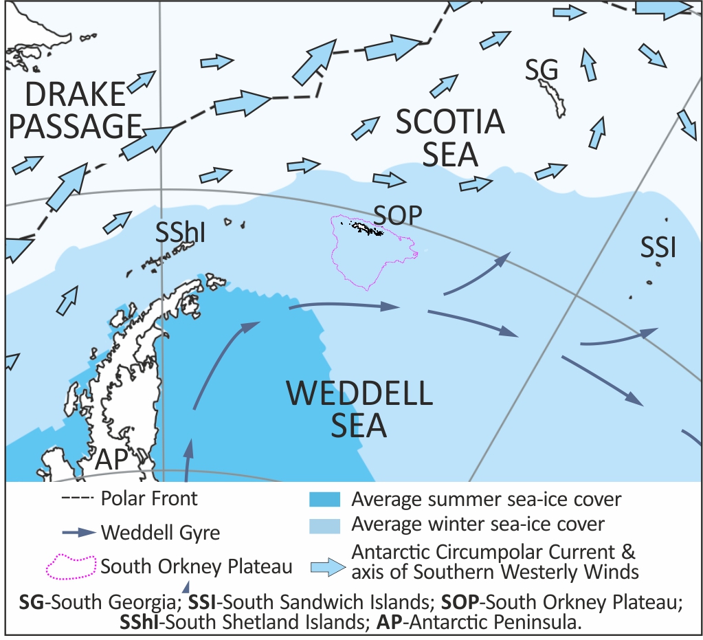
The South Orkney micro-continent also lies in a unique oceanographic position between deep, cold ocean currents formed in the Weddell Sea and the dominant Antarctic Circumpolar Current (ACC) (see map below). Recent observations reveal a poleward shift in the westerly winds that help drive the ACC, which has increased the upwelling of warm Circumpolar Deep Water on to Antarctica’s continental shelves (e.g. Peck et al., 2015). This warm water inflow is thought to be the main driver of recent ice-shelf thinning, glacier acceleration and retreat in Antarctica. With ice sheets increasingly responding to oceanic drivers (including increased heat supply) there is a critical need to improve our understanding of these environmental controls, and the resulting response of the cryosphere.
Over timescales longer than a few decades, unravelling glacier retreat behaviour can only be done by looking to the recent geological past, for example by investigating the response of ice masses during the last deglaciation. As a discrete ice cap with a relatively simple geometry but in a key location, the South Orkneys are ideally situated for an integrated study of climatic change, oceanic drivers and the associated glaciological response (cf. Hodgson et al., 2014) – information that is critically needed to inform future predictions of Antarctic ice-sheet change.
The aim of this project is therefore to understand the pattern and controls of ice retreat of the South Orkney Plateau since the Last Glacial Maximum.

Click on an image to expand
Image Captions
Photo: A view of the glaciated South Orkney Islands close to Signy Island where glaciers still terminate in the ocean. Exactly how do these glaciers respond to oceanic warming? Marine geophysical data and sediment cores that will be used in this project were acquired here on a cruise in 2018. (Photo credit: Robert Paterson),Map: Location of the South Orkney Plateau (pink outline) in a key oceanographic setting between the Antarctic Circumpolar Current and Weddell Gyre. AP is the Antarctic Peninsula, SW of the South Orkneys. How much warm water has reached glaciers on the SOP in the recent geological past as the ACC has shifted towards Antarctica?
Methodology
This project will use untouched marine geophysical and geological datasets, potentially supplemented with terrestrial lake and peat samples, to characterise the retreat behaviour of South Orkneys ice masses in response to regional drivers. Specifically, the student will map seafloor landforms and sediments in glacial troughs on the southern SOP to determine deglacial retreat behaviour since the Last Glacial Maximum (c. 20 ka BP). They will also derive palaeoenvironmental proxy records (e.g. benthic foraminifera to identify water mass/oceanic temperature changes) for the same time period from marine sediment cores. Integration of these datasets will enable the processes controlling retreat behaviour (e.g. external forcing like oceanic warming vs. internal glaciological response) to be determined. We will also use any additional available glacial history information (terrestrial and marine; e.g. Dickens et al., 2014) to constrain our understanding of ice retreat patterns and rates.
There may be an opportunity to acquire new terrestrial environmental change datasets (lake cores, moss records) from the South Orkneys in collaboration with British Antarctic Survey logistics and Dr Tim Lane (Aarhus University, Denmark). Support for the entire project on sub-Antarctic glacial history will come from strong links with project mentors Professors Mike Bentley and Dominic Hodgson at Durham and British Antarctic Survey, respectively. The student will be further supported by other members of the large, energetic Polar research communities in both Cambridge and Durham. Sediment-core analyses will involve working away for short periods (a few weeks) at other UK and international laboratories e.g. Aarhus University, Alfred-Wegener Institute, Germany.
Project Timeline
Year 1
Attend BAS and Iapetus induction and training courses; develop an understanding of glacier retreat (drivers and glaciological response) for sub-Antarctic island/Antarctic Peninsula glaciers then write-up literature review; develop skills for marine geophysical and geological data analysis; determine retreat chronology from marine sediment cores. Organise workshop on sub-Antarctic glacial history. Visit to project supervisors in Durham/Aarhus.
Year 2
Analyse marine datasets to determine new retreat histories (ice sheet limits and configuration, rates of retreat); produce first proxy records for environmental change from marine sediment cores; present results at national conference(s). Continue BAS/Iapetus training courses. Visit to project supervisors in Durham/Aarhus.
Year 3
Finalise environmental change records from sediment cores and geophysical data (e.g., lithostratography and biostratigraphy of sediment cores to derive LGM to recent glacier retreat histories and ocean conditions; glacial landform record and sediment stratigraphy from seafloor datasets); commence thesis writing; present outcomes to Iapetus and at international conference; draft first publication. Visit to project supervisors in Durham/Aarhus.
Year 3.5
Completion and submission of thesis; finalise publication of manuscripts; attend major international conference (e.g., EGU or AGU or INQUA). Visit to project supervisors in Durham/Aarhus.
Training
& Skills
The student will receive training in the description, analysis and interpretation of multibeam swath bathymetric datasets, sub-bottom profiler records and marine sediment cores. Broader, transferrable skills training will be provided via Durham University’s award-winning Career and Research Development (CAROD) group with courses, for example, in writing for publication, thesis writing, presentation skills. The student will also benefit from cross-disciplinary training provided through Iapetus. The student will be a member of the ‘Sea Level, Ice Sheets and Climate Research Cluster in Geography’. The student might be able to participate in either a research cruise or terrestrial fieldwork on Signy Island during the course of the PhD to experience the hands-on data collection in the field. The Signy Island fieldwork would be via the Collaborative Antarctic Science Scheme (CASS; subject to approval). There will be several possibilities for this through participation in existing scheduled cruises led by either BAS or Durham (e.g., via student courses at the University Centre on Svalbard (UNIS) or as part of the BAS-led BELLISSIMO project).
References & further reading
Dickens, W.A., Graham, A.G.C., Smith, J.A., Dowdeswell, J.A., Larter, R.D., Hillenbrand, C.-D., Trathan, P.N., Arndt, J.E., Kuhn, G., 2014. A new bathymetric compilation for the South Orkney Islands
region, Antarctic Peninsula (49°–39°W to 64°–59°S): Insights into the glacial development of the continental shelf. Geochem., Geophys., Geosys., 15, 2494-2514.
Graham, A.G.C., Kuhn, G., Meisel, O., Hillenbrand, C.-D., Hodgson, D.A., Ehrmann, W., Wacker, L., Wintersteller, P., Ferreira, C., Romer, M., White, D., & Bohrmann, G., 2017. Major advance of South Georgia glaciers during the Antarctic Cold Reversal following extensive sub-Antarctic glaciation. Nature Comms., 8, 14798.
Hodgson, D.A., Graham, A.G.C., Roberts, S.J., Bentley, M.J., Ó Cofaigh, C., Verleyen, E., Vyverman, W., Jomelli, V., Saunders, K., M., Selkirk, P.M., Mackintosh, A., Hedding, D.W., Nel, W., Hall, K., McGlone, M.S., Van der Putten, N., Dickens, W.A., Smith, J.A., 2014. Terrestrial and submarine evidence for the extent and timing of the Last Glacial Maximum and the onset of deglaciation on the maritime-Antarctic and sub-Antarctic islands. Quaternary Science Reviews, 100, 137-158.
Jamieson, S.S.R., Vieli, A., Ó Cofaigh, C., Stokes, C.R., Livingstone, S.J. & Hillenbrand, C-D. Understanding controls on rapid ice-stream retreat during the last deglaciation of Marguerite Bay, Antarctica, using a numerical model. Journal of Geophysical Research: Earth Surface. 2014;119:247-263.
Peck, V.L., Allen, C.S., Kender, S., McClymont, E.L., Hodgson, D.A., 2015. Oceanographic variability on the West Antarctic Peninsula during the Holocene and the influence of upper circumpolar deep water. Quaternary Science Reviews, 119, 54-65.