IAP-25-019
Investigating interactions between subglacial landscape evolution and Antarctic Ice Sheet behaviour
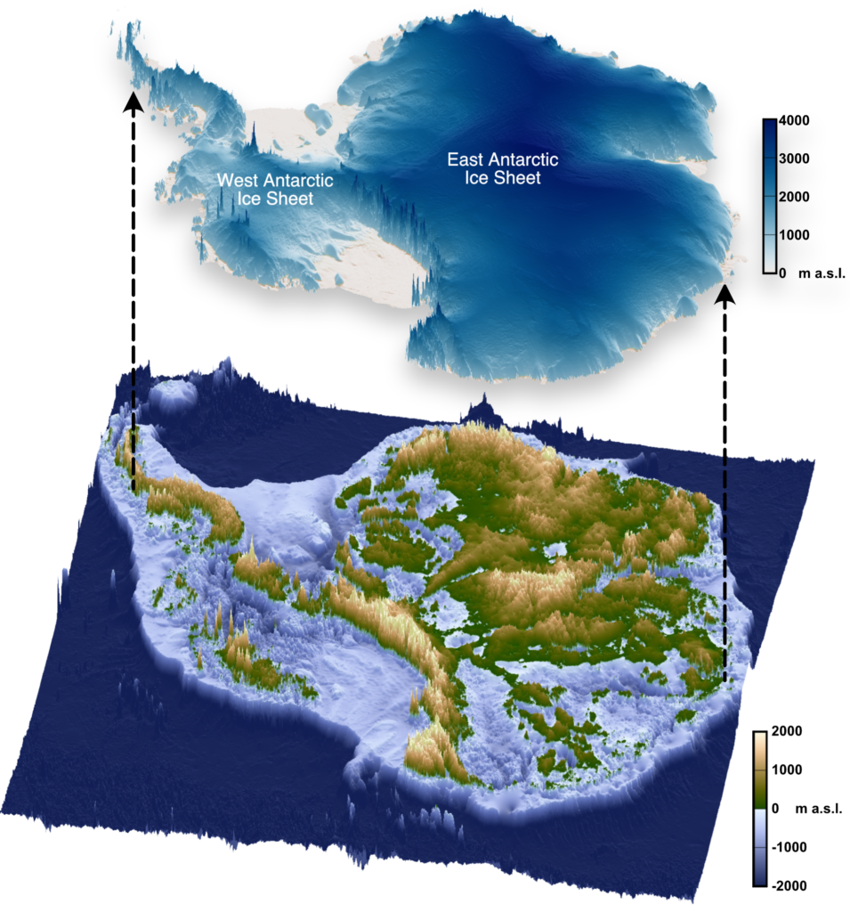
The landscape hidden beneath the Antarctic Ice Sheet (Figure 1) is one of the most mysterious not just on Earth, but on any terrestrial planet in the solar system. The ice sheet that conceals >99% of the Antarctic continent has the capacity to raise global sea levels by around 58 metres and is forecast to become an increasingly important contributor to sea-level rise through the 21st Century and beyond.
However, Antarctica’s future contribution to global sea-level rise is subject to large uncertainties. One of the principal reasons is a lack of understanding of the state of solid Earth beneath the ice sheet (i.e., the sub-ice landscape, crust, and lithospheric mantle) and processes by which the ice sheet and solid Earth interact (Whitehouse et al., 2019; Siegert et al., 2020).
The aim of this project is to investigate the feedbacks between Earth (sub-)surface properties and processes and Antarctic Ice Sheet behaviour over a range of timescales.
In Antarctica, the Earth and ice sheet interact in several important ways. First, the underpinning geological structure can exert a significant influence on ice flow (Jordan et al., 2023), but sub-ice geology and tectonic structure is often poorly constrained. Second, solid Earth deformation and Earth surface processes change the shape of the bed topography beneath the ice sheet over timescales from years to millions of years, which exerts a fundamental control on ice dynamics. However, current reconstructions of bed topography through time (Paxman et al., 2019) do not yet capture the dynamic feedbacks that operate between crustal / lithospheric deformation, erosion and sedimentation, and ice-sheet behaviour. Third, deformation of the solid Earth in response to the redistribution of ice and water mass (‘glacial isostatic adjustment’), can form feedback loops that may modulate the sensitivity of an ice sheet to climate forcing depending on the rheology of the underlying mantle (Nield et al., 2014).
The student will build on previous work by the project supervisors (see above) to develop a coupled modelling framework that incorporates processes associated with solid Earth deformation, landscape evolution (e.g., uplift, erosion and sedimentation) and ice-sheet dynamics. This modelling will be combined with geomorphological and geophysical analysis of the sub-ice landscape to constrain the processes responsible for shaping Antarctica’s topography. The model will be used to quantify the degree to which the solid Earth has influenced the long-term evolution of Antarctica’s landscape and controls the ice sheet’s ongoing and future response to climate change.
The project is multi-disciplinary, with opportunities for the student to develop expertise in a combination of geophysical data analysis and numerical modelling of tectonic deformation, landscape evolution, isostatic adjustment, and ice-sheet dynamics. There is scope to weight the project more towards particular processes depending upon student interests.
The student will be embedded in the ‘Sea Level, Ice and Climate’ research cluster in the Department of Geography in Durham, which is world-leading in the study of glacial landscapes, ice-Earth interactions, and ice-sheet history. The student will also spend time working on polar geophysical data (i.e., radar, gravity, and magnetics) and/or developing tectonic models with supervisor T. Jordan at the British Antarctic Survey. More broadly, this project will be closely linked with the INSTANT (INStabilities and Thresholds in ANTarctica) scientific research program within the 46-nation Scientific Committee on Antarctic Research, and the student will benefit from significant interaction with that international community.
Click on an image to expand
Image Captions
Figure 1: The land surface beneath the Antarctic Ice Sheet. Graphics available via the open-access s-ink.org repository.
Methodology
The project will make use of large, openly available, geophysical datasets (including radar-derived bed topography, gravity and magnetic anomalies, and seismic data) acquired by the British Antarctic Survey and other international partners over the past decade. The student will collate and analyse these datasets to gain an understanding of solid Earth properties in key regions of Antarctica, as well as the tectonic and surface processes that have shaped the present-day subglacial landscape. Geophysical data visualisation and analysis will be carried out in Geographic Information Systems (GIS) software, programming interfaces such as Matlab and/or Python, and proprietary geophysical software. The student will build on existing computer code provided by the project supervisors, as well developing their own scripts.
The student will then develop an integrated numerical model (or models) that incorporates a combination of tectonic deformation, erosion and sedimentation, isostatic adjustment, and ice-sheet dynamics. The modelling framework will be used (depending on student interests) to: (i) quantify feedbacks between surface processes (such as tectonic uplift and erosion) and ice dynamics, (ii) quantify the impact of isostatic adjustment on ice dynamics across a range of timescales (years to millions of years), and (iii) examine the influence of geological structure on ice flow. The results of this analysis will be used to generate a step-change in our understanding of the dominant process(es) by which the solid Earth exerts an influence over long-term ice-sheet evolution, with a particular focus on Antarctica.
Depending on computational demands, data analysis and modelling will be performed locally on the student’s own device and/or on the Hamilton8 supercomputer at Durham University. Durham is equipped with excellent supercomputing provision, with access to key analytical and modelling software such as TopoToolbox and the Parallel Ice Sheet Model (PISM).
The methods described here can be applied to multiple target regions in Antarctica. Options for study areas include (but are not limited to) the Gamburtsev Subglacial Mountains, Dronning Maud Land, and the Antarctic Peninsula.
Project Timeline
Year 1
Assessment and selection of potential study areas using satellite imagery, ice-sounding radar data, and digital elevation models. Analysis of geophysical data to infer solid Earth properties and processes. Training in numerical modelling and familiarisation with existing models.
Year 2
Ascertain the processes to be represented in numerical models, based on specific regional geological context. Attend summer school on ice sheets and glaciers in the climate system. Begin to develop first paper. Progress towards development of a coupled model (i.e., two-way feedbacks between tectonics / erosion / isostasy and ice dynamics). Develop presentation skills by attending UK-based and international conferences.
Year 3
Integrate results of geophysical data analysis with numerical modelling to quantify the interactions between the solid Earth and ice sheet. Present outcomes at international Antarctic-focussed conference. Draft second paper and begin to draft thesis.
Year 3.5
Complete and submit thesis; finalise manuscripts for publication; attend international conference.
Training
& Skills
Techniques in geophysical data analysis and interpretation and numerical modelling will form the core of this project. Development of the necessary skills will be facilitated through in-house expertise in Durham and BAS, via NERC researcher training events, and via internationally recognised summer schools.
Further training in transferable skills, including project management, scientific writing, oral and written communication, and media and public engagement, is available via the award-winning Durham Centre for Academic, Researcher & Organisation Development (CAROD). The student will also benefit from cross-disciplinary training provided as part of the IAPETUS2 DTP. In respect of this project, two of the most relevant training courses are the ‘Introduction to modelling in Python’ and ‘Advanced statistics in R’ modules, but we will discuss the student’s needs and interests at the outset of the project.
The student will be encouraged to present their work at conferences and seminars at Durham and attend relevant national and international conferences throughout the course of their PhD research. The student is also encouraged to apply for small grants from the Royal Geographical Society, British Society for Geomorphology, and Scientific Committee on Antarctic Research, which will allow them to gain experience with writing funding proposals.
References & further reading
Jordan, T. A., Thompson, S., Kulessa, B., & Ferraccioli, F. (2023). Geological sketch map and implications for ice flow of Thwaites Glacier, West Antarctica, from integrated aerogeophysical observations. Science Advances, 9(22), eadf2639.
Nield, G. A., Barletta, V. R., Bordoni, A., King, M. A., Whitehouse, P. L., Clarke, P. J., Domack, E., Scambos, T. A. & Berthier, E. (2014). Rapid bedrock uplift in the Antarctic Peninsula explained by viscoelastic response to recent ice unloading. Earth and Planetary Science Letters, 397, 32-41.
Paxman, G. J. G., Jamieson, S. S. R., Hochmuth, K., Gohl, K., Bentley, M. J., Leitchenkov, G., & Ferraccioli, F. (2019). Reconstructions of Antarctic topography since the Eocene–Oligocene boundary. Palaeogeography, Palaeoclimatology, Palaeoecology, 535, 109346.
Siegert, M., Alley, R. B., Rignot, E., Englander, J., & Corell, R. (2020). Twenty-first century sea-level rise could exceed IPCC projections for strong-warming futures. One Earth, 3(6), 691-703.
Whitehouse, P. L., Gomez, N., King, M. A., & Wiens, D. A. (2019). Solid Earth change and the evolution of the Antarctic Ice Sheet. Nature Communications, 10(1), 503.