IAP-25-073
Discovering the long-term extent and chronology of traditional dryland agriculture
Global policy frameworks increasingly recognize the value of traditional agricultural practices and indigenous technologies in addressing climate change and land degradation. Institutions such as the IPCC (e.g. IPCC 2023 p32; Niang et al 2014) have called for deeper engagement with these systems, particularly in the context of sustainable land and water management. This aligns with the United Nations Sustainable Development Goals—SDG 6 (clean water and sanitation) and SDG 15 (life on land)—which highlight the urgent need to combat desertification and promote sustainable water use.
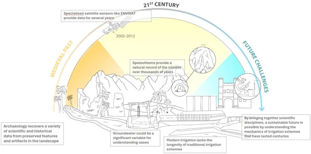
Dryland regions especially the Middle East and North Africa face acute water scarcity driven by climate change and population growth, exacerbated by unsustainable groundwater extraction. These dynamics threaten long-term water security and have led to the desertification of traditional, human-engineered oases —landscapes that have sustained communities for millennia (Rayne et al 2023; Cigna et al 2025; Hayes-Rich 2024).
This project aims to address these challenges by investigating the historical resilience and contemporary vulnerability of traditional oasis systems. It will:
Aim 1) Develop new remote sensing approaches to map the distribution of traditional oases in the MENA region (concentrating on case studies in the Skoura Basin, Morocco and Ayn Sayad, Iraq).
Aim 2) Establish the long-term chronology of these oases, quantifying their historical extent and the rate of recent desertification.
Aim 3) Assess the impacts of water scarcity and land degradation on these landscapes.
Aim 4) Translate findings into actionable insights for sustainable landscape and water management policy.
Key deliverables:
1.) Landscape Characterisation: Using machine learning-based landcover models applied to satellite imagery, the project will identify and quantify degraded versus cultivated land across selected case studies and map the distribution of water management systems. These models will build on and refine existing algorithms developed by the lead supervisor.
2.) Chronological Analysis: Historical maps and archaeological fieldwork—including optically stimulated luminescence (OSL) dating—will provide the time-depth perspective of land use changes and oasis resilience.
3) Desertification and Water Mapping: The project will quantify the rate and spatial distribution of desertification, with a focus on traditional water management systems such as khettara/qanat, wells, and springs. It will also evaluate existing groundwater management strategies.
The supervisory team brings extensive expertise in remote sensing, OSL dating, groundwater analysis, and landscape archaeology, with a strong track record of collaborative research across drought-affected regions including Morocco, Spain, Greece, Egypt, Jordan, Iraq, Turkey, and Oman. The project offers significant flexibility for the PhD researcher to shape the direction of their work, supported by a robust network of regional partnerships.
Click on an image to expand
Methodology
This project will employ an interdisciplinary approach combining remote sensing, archaeological fieldwork, hydrological data, and scientific dating techniques to investigate the historical resilience and contemporary degradation of traditional oasis systems.
Remote Sensing and GIS (Geographical Information Systems)
Building on machine-learning algorithms developed by Rayne et al. (2023), satellite imagery will be used to classify landcover and quantify the proportion of degraded versus cultivated land across selected case study regions. These algorithms will be further refined and scaled to cover broader areas, enabling the identification of patterns of agricultural intensification and decline.
Oases identified by algorithm as having both degraded and active land would be examined using high resolution satellite imagery (e.g. the extensive Corona and Hexagon imagery already in Rayne’s archives). Ancient/traditional cultivation techniques including irrigation will be identified and digitised and the changing historic landscape character will be analysed in GIS. A systematic review of published evidence on groundwater management strategies—such as khettara/qanat systems, wells, and springs—will complement the spatial analysis.
Fieldwork and Chronological Analysis
Targeted field investigations will be conducted in the Skoura Basin, Morocco, focusing on archaeological survey of water infrastructure and agricultural field systems. Chronological data will be obtained through optically stimulated luminescence (OSL) profiling using a portable IRSL/OSL reader (SUERC), allowing for in-situ dating of sediment layers and land use changes (Brandolini et al 2025). Additional OSL samples will be provided by collaborators working in Ayn Sayad, Iraq (Jotheri et al 2025), where ongoing fieldwork offers a valuable comparative dataset. These samples will contribute to establishing a time-depth understanding of oasis development and desertification processes.
Project Timeline
Year 1
Deliverable 1: Landscape Characterisation: – remote sensing skills training and model development
The candidate will be trained by Rayne in GIS (Geographical Information Systems) and remote sensing at the School of History, Classics and Archaeology at Newcastle University. They will develop a model to map the extent of vulnerability of active and desertified oases in the MENA region. This will, in part, be built from a machine-learning algorithm created by the principal supervisor for automated mapping of degraded vs cultivated land (Rayne et al 2023). Past and present oasis soils, vegetation and water management systems will be detected from analysis of open-access satellite imagery (Copernicus Sentinels, Hexagon) and validated through historical maps and archaeological accounts.
Year 2
Deliverable 2: Chronological Analysis
A) Fieldwork – Skoura, Morocco
Skoura oasis relies and has relied on on traditional water management practices for centuries. It is located at the confluence of several rivers originating in the High Atlas mountains. Geological mapping indicates four aquifer systems overlying impermeable clays and marls. The area contains many fortified historical structures, and khetteras, a traditional tunnelling method for collecting groundwater. Much of the knowledge about irrigation and farming in this region comes from indirect evidence (Mahdane et al 2011), scientific approaches have yet to be employed. A key challenge is that dating historical water management and field systems is difficult, and without a chronology rates of change cannot be quantified. Typically, radiocarbon dating is relied upon, but this is only possible when organic material is preserved in secure contexts. In partnership with Yassine Ait Brahim at the Université Mohammed VI Polytechnique, Morocco, and assisted by Rayne and Kinnaird, the student will undertake a single campaign of fieldwork at Skoura. This will allow the candidate to: 1. validate their maps created in year 1, through ground-truthing the key structural features; 2. assess the historical character of the landscape; 3. apply geo-archaeological methods including OSL to investigate historical land-use, assess environmental data, and quantify landscape change.
B) Delivered samples- Ayn Sayad, Iraq
Although travel from the UK to Iraq is unlikely to be possible, Jotheri and his team from Al-Qadisiyah University in Iraq are conducting ongoing field projects in the region (Jotheri et al 2025). Ayn Sayad is one of c.200 springs associated with the Abu Jir lineament of southern Iraq (Cigna et al 2025). They are situated at the junction of the Arabian Desert and the Mesopotamian floodplains of the Euphrates and Tigris Rivers. Fortresses dating back to the Sasanian period are linked to these springs which supported agriculture through the use of irrigation canals. Today, Ayn Sayad supports a unique culture of farmers who are now losing their livelihood due to the impact of drought, dust storms and over-pumping. The student will coordinate with Jotheri to receive OSL samples collected from Ayn Sayad.
C) OSL profiling and dating of earthworks and other structures associated with water management:
The candidate will be trained in OSL-PD at the School of Earth and Environmental Sciences, University of St Andrews (supervised by Kinnaird) where the OSL samples will be processed. The candidate will use OSL-PD to date field earthworks and water management structures identified during deliverable 1, this will enable them to quantify the extent and rate of land-use change at the desertified oases.
Year 3
Deliverable 3: Desertification and Water Mapping: Quantifying and modelling the rate of desertification at Skoura, Morocco, and Ayn Sayad, Iraq
An accurate map of the extent, chronology and reasons for desertification in the case study regions will be created. The student will review archaeological and historical literature (supported by Rayne and Turner), and groundwater management data (supported by Ait Brahim) to identify causes of desertification.
Accurate mapping of desertification is urgently needed to facilitate future planning and inform adaption strategies for agriculture, heritage and tourism. The end product will be a model with the extent and chronology of long-term desertification quantified.
Year 3.5
Thesis writing completion; Writing and submission of an interdisciplinary journal article led by student e.g. to Journal of Arid Environments.
Training
& Skills
The supervisory team will mould training to the student’s needs via compulsory and optional training modules and other activities specific to the project. Participation in the School of History, Classics Archaeology’s (Newcastle) Researcher Training Programme will develop contextual knowledge and critical heritage thinking, while practice-based learning co-delivered with partners will strengthen sector ties, build transferrable skills and enhance employability. An initial training needs analyses (TNA) will be completed at the start of the project and annually thereafter to identify needs and calibrate training progress. Progress against training needs will also be reviewed informally during supervision and formally during the annual progress review procedure which is completed by all postgraduate research students at Newcastle.
Deliverable 1 – Training in remote sensing through 2 modules at Newcastle, ARA3295 Fundamentals of Digital Humanities Computer literacy, data analysis and GIS; DSC8XXX Geospatial Challenges in the Humanities (a new MSC course starting in 2026).
Deliverable 2 -training in OSL-PD through 1 month secondment at the CERSA luminescence laboratories in the School of Earth and Environmental Sciences, University of St Andrews. In addition, practical training in the field-based component will be delivered in Morocco.
Deliverable 3 – Landscape archaeology by attending module at Newcastle ARA8234 Landscape Archaeology.
References & further reading
IPCC, 2023: Summary for Policymakers. In: Climate Change 2023: Synthesis Report. Contribution of Working Groups I, II and III to the Sixth Assessment Report of the Intergovernmental Panel on Climate Change [Core Writing Team, H. Lee and J. Romero (eds.)]. IPCC, Geneva, Switzerland, pp. 1-34, doi: 10.59327/IPCC/AR6-9789291691647.001
Niang, I., O.C. Ruppel, M.A. Abdrabo, A. Essel, C. Lennard, J. Padgham, and P. Urquhart, 2014: Africa. In: Climate Change 2014: Impacts, Adaptation, and Vulnerability. Part B: Regional Aspects. Contribution of Working Group II to the Fifth Assessment Report of the Intergovernmental Panel on Climate Change [Barros, V.R., C.B. Field, D.J. Dokken, M.D. Mastrandrea, K.J. Mach, T.E. Bilir, M. Chatterjee, K.L. Ebi, Y.O. Estrada, R.C. Genova, B. Girma, E.S. Kissel, A.N. Levy, S. MacCracken, P.R. Mastrandrea, and L.L.White (eds.)]. Cambridge University Press, Cambridge, United Kingdom and New York, NY, USA, pp. 1199-1265
Hayes-Rich, E., 2024. The Mouth of the Jebel Bani Mountains: Traditional Water Management at the Edge of the Sahara. Ethnoarchaeology, 16(1), pp.28-56.
Brandolini, F., Kinnaird, T.C., Srivastava, A., Costanzo, S., Compostella, C. and Turner, S., 2025. Geoarchaeology reveals development of terrace farming in the Northern Apennines during the Medieval Climate Anomaly. Scientific Reports, 15(1), p.24989.
Brandolini, F., Kinnaird, T., Srivastava, A., Turner, S. 2023. ‘Modelling the impact of historic landscape change on soil erosion and degradation’. Scientific Reports 13, 4949.
Cigna, F., Rayne, L., Makovics, J.L., Irvine, H.K., Jotheri, J., Algabri, A. and Tapete, D., 2025. Environmental Challenges and Vanishing Archaeological Landscapes: Remotely Sensed Insights into the Climate–Water–Agriculture–Heritage Nexus in Southern Iraq. Land, 14(5), p.1013.
Khettouch, A., Hssaisoune, M., Ait Brahim, Y., Ez-Zaouy, Y., Hermans, T. and Bouchaou, L., 2025. Towards sustainability in dry land oases: water quality challenges. Environmental Research Communications, 7(8), p.085011.
Kinnaird, T.C., Abellán Santisteban J., Brandolini F., Carlton, R., Carrer, F., Civantos, J-M., Duggan, M., Holcomb, J.A., Lekakis, S., Ramos Rodriguez, B., Salazar, N., Sanchez Pardo, J-C., Sevara, C., Snyder, J.R., Shillito, L-M., Silva Sanchez, N., Srivastava, A., Turner, A. 2025. Unearthing the histories of agrarian landscapes: a research framework for Terraces as Sustainable Environments. Geoarchaeology 40(2), e70004.
Fensham, R.J., Adinehvand, R., Babidge, S., Cantonati, M., Currell, M., Daniele, L., Elci, A., Galassi, D.M., de la Hera Portillo, Á., Hamad, S. and Han, D., 2023. Fellowship of the Spring: An initiative to document and protect the world’s oases. Science of the Total Environment, 887, p.163936.
Jotheri J, Al-Mayali R, Al-Gburi A, Rayne L, Al-Gabri A, Haddad A, Al-Hamzah M. Irrigation systems in the Iraqi Western Desert: Abu Jir Springs line as a case study. In: Insoll, T; Maclean, R; Almahari, S, ed. The Archaeology of Irrigation Technology and Water Management in the Islamic World. Oxfordshire: Archaeopress Archaeology, 2025.
Herring, P., S. Turner, C. Sevara. 2022. The Historic Landscape: assessing opportunity for environmental change. Historic England Research Report Series 69/2022.
Rayne, L., Brandolini, F., Makovics, J.L. et al. Detecting desertification in the ancient oases of southern Morocco. Sci Rep 13, 19424 (2023). https://doi.org/10.1038/s41598-023-46319-1
Turner, S., T. Kinnaird, E. Koparal, S. Lekakis, C. Sevara. 2020. ‘Landscape archaeology, sustainability and the necessity of change’, World Archaeology 52(4), 589-606.