IAP-25-144
Developing a landslide dynamic hazard model
Landslides have significant social, economic, and environmental impacts, accounting for ~ 72,000 deaths and over $11.5B of damage worldwide between 1900 and 2022.
These events are usually caused by an interplay of predisposing, preparatory, and triggering environmental factors. Analysing these drivers jointly in space and time within a single modelling framework remains a major scientific challenge. Consequently, we lack robust, holistic models capable of anticipating and mitigating landslide impacts. Recent statistical advances, e.g., joint occurrence–magnitude (hurdle) models and log-Gaussian Cox process (LGCP) formulations, demonstrate how probabilistic frameworks can bridge this gap (Bryce et al., 2022; Bryce et al., 2025).
Existing global and regional landslide models suffer from two main limitations:
– Incomplete and biased inventories: Regional landslide inventories rarely provide a spatially representative sample of past slope instabilities due to inconsistent mapping practices. This often leads to underrepresentation of landslide populations and systematic biases in resulting models.
–
Static hazard modelling: Even recent AI data-driven approaches largely treat susceptibility as a quasi-static property (based on lithology, slope, and long-term climate statistics). While such models identify where landslides may occur, they generally neglect the temporal dimension, i.e., when or under what evolving conditions failures are likely, treating space and time separately rather than dynamically.
This project aims to overcome these limitations by developing the first spatio-temporal dynamic hazard model for landslides. By explicitly integrating time-varying environmental drivers (high-resolution rainfall and InSAR-derived ground motion) the project will provide both nowcasts and forecasts that reflect the evolving state of the landscape.
Key innovations
1. Spatio-temporal dynamic hazard modelling: Unlike existing landslide susceptibility maps based on static covariates (e.g., lithology, slope angle, long-term rainfall averages), this project will develop a dynamic modelling framework that explicitly integrates time series of rainfall (gauges + gridded products) and ground motion (InSAR) within a spatio-temporal statistical model. Landslide occurrence will be modelled using log-Gaussian Cox processes (LGCPs) to estimate intensity with quantified uncertainty (Bryce et al., 2025), and (where data permit) occurrence and size/volume will be coupled via joint (hurdle) models (Bryce et al., 2022). The framework will be cast as a hierarchical Bayesian latent-Gaussian model with SPDEs to capture spatial and temporal dependence, propagate uncertainty, and perform bias-aware inference for incomplete inventories; we will benchmark against spatio-temporal machine-learning baselines. The result is probabilistic hazard forecasts that answer not only where and when landslides are likely, but, via joint modelling, how large they may be.
2. Landslide magnitude (density and volume) estimation: Beyond occurrence prediction, the project will provide probabilistic estimates of landslide volume and density, critical for understanding run-out distances, infrastructure risk, and required countermeasures.. By combining empirical scaling laws (relating landslide area and depth to volume) with InSAR-derived pre-failure deformation and geological controls, the project will develop joint statistical models for occurrence and magnitude, enabling realistic scenario generation for risk management. This will allow stakeholders not only to anticipate if and where a failure may occur, but also how large it is likely to be.
Methodological contribution
The project will advance statistical modelling for natural hazards by:
• Developing integrated spatio-temporal point process models that link triggering rainfall to slope instability while accounting for spatial heterogeneity.
• Employing Bayesian hierarchical frameworks to propagate uncertainty from incomplete inventories and observational errors into forecasts.
• Exploring ensemble blending of statistical and machine learning models to balance predictive accuracy with interpretability.
• Embedding probabilistic volume estimation directly into the hazard model, moving beyond binary occurrence predictions.
Outcomes and impact
The project will deliver the next generation of landslide hazard forecasting tools, shifting from static susceptibility maps to dynamic probabilistic forecasts of timing, location, and magnitude. These outputs will directly support decision-makers and emergency responders by improving early warning systems, informing risk planning, and ultimately helping reduce loss of life and economic damage. Case studies will be conducted in contrasting climatic regions, with Scotland as a key testbed through collaboration with the Natural Hazards Partnership.
This work will provide key information for the creation of a new generation of BGS products on landslides hazards which will improve existing offering based on susceptibility (e.g., GeoSure) which only account for the spatial probability of a landslide.
Training and skills development:
The successful PhD candidate will gain a highly marketable and interdisciplinary skillset that combines:
• Geographic Information Systems (GIS): for spatial data integration and mapping
• Statistical & machine learning methods: advanced Bayesian hierarchical modelling, spatio-temporal processes, uncertainty quantification, and probabilistic forecasting.Earth observation (EO): including satellite-derived information on ground deformation (InSAR) and rainfall datasets for monitoring environmental processes.
These skills are not only essential for delivering the project objectives but are also in high demand across academia, government agencies, and industry, ensuring excellent career prospects beyond the topic of this PhD.

Click on an image to expand
Image Captions
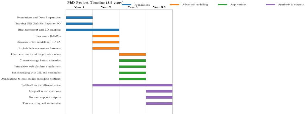
Figure 1 – Left: Ground motion data and trends derived from InSAR data over Great Britain (from Medici et al., 2025). Right: Gantt chart, detailing the PhD project timeline.
Methodology
The methodology needed to achieve the objective includes four main activities:
1) The work includes a two-week fieldwork in Scotland to collect data on landslides type, lithology and volume.
2) Literature review on existing data-driven model to understand pros and cons
3) Placement at BGS (first period) to familiarise with landslide research and GIS skills and improve existing landslides inventory using satellite data with mapping techniques developed at BGS.
4) Integrating space and time in landslide hazard models is rarely attempted. The project will begin with a generalised additive mixed modelling (GAMM) framework, which offers a flexible and interpretable entry point for the PhD student. A binary GAMM will integrate precipitation at multiple temporal scales with static ground conditions and seasonal effects, while accounting for known data limitations. A major challenge is the bias and incompleteness of landslide inventories, which often overrepresent events near transportation routes and urban areas. To address this, we will:
– Introduce bias-related covariates in the model fitting that are excluded during prediction (Lima et al., 2017), and
– Implement an independent EO-based mapping procedure using Sentinel-2 imagery and automatic detection tools developed at BGS, ensuring consistent quality and coverage of the National Landslide Database (NLD).
Building on the GAMM baseline, the project will progress to more advanced statistical methods:
– Hierarchical Bayesian models with SPDEs (via R-INLA) to capture spatial dependence and temporal dynamics in a probabilistic framework.
– Joint occurrence-magnitude modelling to provide not only forecasts of when and where landslides may occur but also probabilistic estimates of size/volume, critical for risk assessment.
– Uncertainty quantification through Bayesian inference, yielding credible intervals for hazard forecasts and enabling sensitivity analyses.
– Benchmarking with machine learning methods (e.g. gradient boosting, spatio-temporal neural nets), with the option to use ensemble blending where this improves predictive skill.
This staged approach ensures feasibility at the start of the PhD while leaving scope for innovation and methodological development. The outcome will be the first dynamic, bias-aware statistical framework for forecasting both landslide occurrence and magnitude, with applications extendable to other natural hazards.
5) The assessment of landslide occurrence timing is frequently hindered by the absence of multi-temporal data or historical records on triggering events such as rainfall or earthquakes. For large areas, empirical approaches have traditionally been the primary choice for determining critical rainfall conditions for landslide occurrence. These approaches are based on rainfall thresholds from past landslide observations and often serve as the foundation for early warning systems.
Conventionally, these methods focus only on the triggering precipitation information. However, there is a growing trend toward incorporating hydrological effects and medium-term antecedent precipitation conditions Another relevant issue lies in the prevalent adoption of a presence-only framework, which focuses exclusively on rainfall events leading to landslide occurrences while disregarding rainfall events that do not trigger landslides. Currently, few studies have embraced presence-absence frameworks, commonly observed in landslide susceptibility studies, with the distinction that susceptibility solely accounts for static ground-related conditions (e.g., slope steepness, lithology), while rainfall thresholds are dedicated to the meteorological aspects. This situation highlights the current separation in the geoscientific literature between two components of the landslide hazard definition i.e., where and when landslides may occur. Our GAMM solution better capture long-term meteorological trends or predisposition rather than short-term dynamics.
6) Placement at BGS (second period of three) large dataset analysis to derive volumes and hazards levels.
Project Timeline
Year 1
Foundations and Data Preparation
• Comprehensive literature review on landslide modelling, spatio-temporal statistics, and EO applications.
• Training in GIS, GAMMs, Bayesian inference (R-INLA/Stan), and EO data processing.
• Assembly of datasets: rainfall (gauges + gridded), InSAR ground deformation, and National Landslide Database (NLD).
• Pilot analysis with generalised additive mixed models (GAMMs) to establish baseline spatio-temporal predictions.
• Initial work on bias assessment and integration of Sentinel-2 EO mapping into the landslide database.
Year 2
Advanced Statistical Modelling
• Development of bias-aware GAMMs, incorporating bias-related covariates and EO mapping corrections.
• Extension to Bayesian hierarchical models with SPDEs (via R-INLA) to capture spatial dependence and temporal dynamics.
• First probabilistic forecasts of landslide occurrence, including uncertainty quantification.
• Presentation of early findings at conferences/workshops.
Year 3
• Run future hazard scenarios under different climate change scenarios
• Develop an interactive web platform to run simulations
Joint Modelling, Scenarios, and Applications
• Development of joint occurrence–magnitude models, combining empirical scaling laws with InSAR pre-failure deformation.
• Generation of probabilistic forecasts of landslide size and timing.
• Benchmarking statistical models against machine learning approaches (e.g. gradient boosting, spatio-temporal neural nets).
• Run future hazard scenarios under different climate change conditions (e.g. using downscaled rainfall projections).
• Develop an interactive web platform to demonstrate and run simulations with project stakeholders.
• Application of models to test sites in contrasting climatic regions, including Scotland (with the Natural Hazards Partnership).
• Preparation of manuscripts for peer-reviewed journals.
Year 3.5
Synthesis and Thesis Submission
• Integration of results into a coherent dynamic hazard forecasting framework.
• Production of decision-support outputs (maps, probabilistic scenarios, risk indicators).
• Finalisation of manuscripts for submission.
• Writing, revision, and submission of the PhD thesis.
• Dissemination of findings to academic, government, and industry stakeholders.
Training
& Skills
The student will build strong expertise in spatio-temporal statistics—GAMMs, Bayesian hierarchical models with SPDEs (via R-INLA)—with a focus on uncertainty quantification and bias-aware inference for incomplete inventories. They will gain EO/GIS capability (InSAR ground motion, rainfall products) and research software engineering skills in R/Python (version control, reproducible workflows, scalable computation). Methods training includes joint occurrence–magnitude modelling, climate-change scenario analysis, and building an interactive decision-support web platform. Complementary skills cover ML benchmarking, scientific writing/presentation, and stakeholder engagement (e.g., Natural Hazards Partnership), preparing the student for careers in environmental risk, geospatial data science, and academia/industry.
References & further reading
Bryce, E., Lombardo, L., Van Westen, C., Tanyas, H., & Castro-Camilo, D. (2022). Unified landslide hazard assessment using hurdle models: a case study in the Island of Dominica. Stochastic Environmental Research and Risk Assessment, 36(8), 2071-2084.
Bryce, E., Castro-Camilo, D., Dashwood, C., Tanyas, H., Ciurean, R., Novellino, A., & Lombardo, L. (2025). An updated landslide susceptibility model and a log-Gaussian Cox process extension for Scotland. Landslides, 22(2), 517-535.
Medici, C., Novellino, A., Dashwood, C. and Bianchini, S., 2025. Machine learning and clustering for supporting the identification of active landslides at national scale. International Journal of Applied Earth Observation and Geoinformation, 140, p.104608.