IAP-25-054
Determining the Impacts of Wildfires, from a local to global scale, using Satellite-based Observations.
Background:
As shifts in climate alter temperature and rainfall patterns, we are observing an increase in the number and extent of wildfires both globally1 and regionally2. These events have the potential to devastate ecosystems while also contributing significant volumes of aerosols to the atmosphere. This research aims to assess wildfires across a range of spatial scales. Two key themes will be explored. Firstly, Scottish wildfires will be assessed from a multi-disciplinary approach, with the aim of evaluating the ecological impact of the burn area (e.g., via field or remote assessment methodologies) and classifying the effects associated with plumes emissions (e.g., air quality monitoring). Secondly, the impacts of plumes generated from large magnitude events occurring across key global sites (e.g., Canada 2023 & 2025; LA 2025, Spain/Portugal 2025) will be investigated with novel remote sensing techniques. In addition to the direct observations, the output of this analysis will provide improved estimates of wildfire aerosol contributions3 for inclusion into global radiation calculations in climate models. The primary analyses will be conducted with remote sensing methodologies, however there is scope within the project for the completion of field-based analysis of recent burn scars, for improved ecological assessment, depending on the interest of the successful candidate.
Expected responsibilities:
Within this research project the candidate will be responsible for compiling information on the extent and composition of aerosols and/or particles emitted from wildfires. Individual events will be tracked, and the composition of the particles will be inferred using existing techniques1, where these are available. The primary focus of this research, will be to develop new methods of detecting and tracking emitted aerosols and particles, through the analysis of data from NASA’s new PACE sensor (Plankton, Aerosol, Cloud, ocean Ecosystem: https://pace.oceansciences.org/about.htm). This project represents an opportunity for the selected PhD candidate to develop novel methods for conducting remote observations of environmental hazards with global applicability. Should the student choose to undertake field measurements, it is expected that field sampling will include the analysis of plant/soil samples from recent Scottish wildfire sites, to assess the impact of fire intensity on ecological degradation.
Technical Skills:
It is expected that the candidate will have a strong interest in, or experience analysing, environmental hazards that generate atmospheric plumes (e.g., volcanoes, wildfires and/or dust storms). The candidate should have experience with the processing of remote sensing data and be proficient in geospatial analysis techniques. Due to the intention to develop novel single- or multi-sensor algorithms for categorising atmospheric plumes, it is expected that the student will have a proficiency with coding, or the capability to refine and develop these skills during their PhD. Guidance will be provided on this algorithm development through the wider supervisory team.
Click on an image to expand
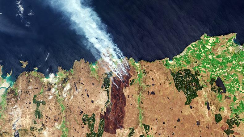
Image Captions
Sentinel-2 MSI image of Melvich Fire 2019. Source: ESA
Methodology
Deliverables: The primary deliverable of this project will be an algorithm for conducting remote assessment of the environmental impact of aerosols using free to access data. It is expected that this will be user friendly and made publicly available upon completion of the PhD. Facilitating its widespread use and improving global assessment capabilities.
Novelty: The project will utilise cutting-edge satellite technology to develop new techniques for the analysis of environmental hazard events. The outputs generated as part of this project have the potential to be beneficial to the global hazard assessment community, in addition to providing insight for the climate modelling community.
Data: Archived and ongoing observations from PACE (NASA), Sentinel-2 and 5p (European Space Agency) and legacy data from MISR, MODIS, ASTER (NASA) & Landsat (United State Geological Service) where relevant. Depending on prior experiences of the successful candidate SAR observations (e.g., Sentinel-1) may also be incorporated into the analysis of burn scars.
Key research components:
Environmental Analysis: The selected candidate will select areas of interest and perform investigations into the characteristics of the wildfire events selected. These endeavours are likely to result in the publication of a series of papers categorising the composition of plumes and extent of impact in these individual cases, while providing the opportunity to develop a novel methodology for improved wildfire assessment.
Algorithm Development: A key component of this project will be the development of a targeted algorithm designed to categorise the observations of atmospheric plumes generated by wildfire events. The exact details of this will depend on the progress made by the selected candidate and the targets they choose to investigate.
Location: The project will primarily be desk based. Primary data sources will be satellite-based remote sensing data. For established sensor data, algorithms will be available, and it is expected that you will become proficient with the processing of these data. For sensors where the expectation is the development of dedicated algorithms, there may be opportunities to collaborate with national/international research partners, either remotely or in person, where funds allow. Should the successful candidate choose to undertake fieldwork, the sample sites are expected to be located across Scotland at sites of recent wildfire events.
Project Timeline
Year 1
Preparing literature review on related topics. Begin downloading and processing remote sensing data using existing techniques, to become familiar with current capabilities. It is expected that this will be done through the selection and investigation of relevant wildfire events. The output of these analyses will result in the submission of a journal article.
Year 2
Develop multi-sensor methods for the assessment of wildfires using novel technologies and/or methodologies, refined during the first year of study. It is expected that the developed technique will be written up as a journal article and submitted after the second year. If fieldwork is being undertaken it is expected that primary sampling will be conducted at the beginning of year 2 with scope for repeat site visits up until the middle of year 3.
Year 3
The final year will continue the algorithm development, refinement and validation process and will likely result in the publication of at least one case study analysis using the multi-sensor technique devised. If fieldwork was conducted it would be expected that the outcome from these analyses would result in the publication of a dedicated article on these results.
Year 3.5
Engage with end-users to refine the algorithm and user interface developed, complete & submit thesis, and undertake viva.
Training
& Skills
This is a multi-disciplinary project encompassing a) geology/atmospheric/environmental science, b) remote sensing, c) data analysis & d) algorithm development.
The successful candidate will have the opportunity to develop skills in these areas through engagement with their interdisciplinary research supervisors. Additionally, attending training courses, such as those operated through the NASA ARSET (Applied Remote Sensing Training Program) or similar sources, will be encouraged.
The candidate will also be encouraged to take non-subject specific trainings to enable the development of a broader skill set beyond their academic studies, such as those provided through the University of Stirling Institute of Advanced Studies (IAS).
References & further reading
NASA PACE: https://pace.oceansciences.org/about.htm
• Remer, L. A., Davis, A. B., Mattoo, S., Levy, R. C., Kalashnikova, O. V., Coddington, O., … & Zhai, P. W. (2019). Retrieving aerosol characteristics from the PACE mission, Part 1: Ocean Color Instrument. Frontiers in Earth Science, 7, 152. https://www.frontiersin.org/journals/earth-science/articles/10.3389/feart.2019.00152/full
ESA: https://www.esa.int/Our_Activities/Observing_the_Earth/Copernicus/Sentinel-1/Satellite_constellation
NASA EOS: https://eospso.nasa.gov/content/nasas-earth-observing-system-project-science-office
References:
1 Cunningham, C. X., Williamson, G. J., & Bowman, D. M. (2024). Increasing frequency and intensity of the most extreme wildfires on Earth. Nature ecology & evolution, 8(8), 1420-1425. https://www.nature.com/articles/s41559-024-02452-2
2 Tasker, S., & Wentworth, J. (2024, April). Wildfire risks to UK landscapes. http://nflg.co.uk/files/POST-PN-0717.pdf
3 Zielinski, T., Willems, A., & Lartigaud, M. (2024). Impact of biomass burning, wildfires, and wind events on aerosol optical depth: implications for climate change. Applied Sciences, 14(13), 5633. https://www.mdpi.com/2076-3417/14/13/5633