IAP-25-127
Can microclimate refugia save an iconic floral assemblage under climate change?
Globally, land-use change is the major driver of species loss, but climate change is rapidly catching up (1). Projecting how species will respond to climate change is essential for effective conservation, yet efforts so far have been hampered by two critical limitations – a poor understanding of the interactions between drivers of biodiversity loss, and crude climate data that fails to capture the microclimate as it is experienced by living organisms (2). If we can address these oversights, not only can we improve our understanding of historical biological responses to climate change, but we can also improve our forecasts and inform meaningful actions to conserve species under environmental change.
Teesdale in the North Pennines of the UK represents a living laboratory and a nationally exceptional floral assemblage. The assemblage comprises southern species at their northern range limit juxtaposed with northern species at their southern range limit: in other words, ecologically remarkable species living at the margins of their suitable climatic envelope (3). As the climate warms, we would expect that the northern species would be lost and that southern species would advance, yet evidence suggests that this rarely happens as we expect and that microclimates provide refugia that buffer change (4,5). Given the variable microtopography and geology of this upland landscape, there likely exists microclimates that provide such refugia, but climate is not the only driver of change. The Teesdale fells have been grazed by sheep for generations, and as sheep numbers change, so does the vegetation and its distribution. The extent to which climate change and sheep grazing interact to determine the fate of the Teesdale flora is not understood and could hold the key to both conserving these rare plants on a local scale, and to a better understanding of climate/land-use interactions on a global scale.


Click on an image to expand
Image Captions
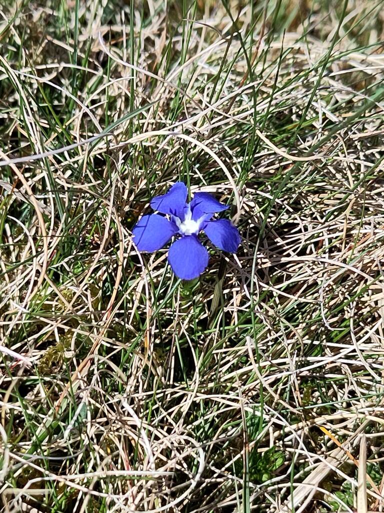
The landscape of Upper Teesdale,Flora of Upper Teesdale, including rare mountain avens (Dryas octopetala). Spring gentian, Gentiana verna, found only in Upper Teesdale in the UK.
Methodology
An ambitious component of this project is establishing microclimate and vegetation monitoring plots in a fractal sampling design (6) that captures the full spectrum of microclimate space (7), following the guidelines of and feeding data into the MicroFractal Network: https://ecofracnetwork.github.io/protocol/. This study design is key in allowing us to identify not just biological and microclimatic variation across the landscape and through time, but also how these patterns change across scales. In this way, we can quantify the degree of spatial homogenisation, as well as the importance of microhabitats and microclimates for supporting unique flora that are otherwise rare at the landscape scale, which is likely to be those species at the limits of their climate niche.
Microclimate typically deviates from the ‘macroclimate’ of the landscape because of fine-scale variation in two factors: vegetation and topography. Thus, at the same monitoring plots we will use cutting edge techniques to quantify vegetation structure through time using phone-based LiDAR, potentially combined with drone-based LiDAR to assess vegetation structure and topography of the whole landscape. This will facilitate extrapolation of results from the plot-level, to characterise the spatiotemporal distribution of microclimates across the landscape and to identify possible refugia for rare plant species.
The final component of fieldwork requires monitoring sheep movement patterns across the site, to understand where they are spending time and the extent to which this may interact with microclimate to determine plant species distribution at fine scale. We will select a representative sample of sheep for tracking using combined GPS data loggers and triaxial accelerometers. GPS telemetry will provide data on fine scale movement and location, whilst accelerometry will provide scope for developing automatic classification of behaviours with respect to time and location.
It should also be noted that microclimate monitoring and botanical surveys have been underway in this landscape for decades, providing a rich and ready source of historical data. There are also long-running experimental plots investigating warming and grazing impacts. These existing datasets act to mitigate the risks of fieldwork, as well as providing exceptional historical data to complement newly collected data.
Throughout the project, the student will work closely with the Senior Reserve Manager at Natural England and with local landowners to ensure that the project not only runs smoothly but also retains local relevance for the end users who manage this landscape.
Project Timeline
Year 1
Month 1: Core induction programmes for IAPETUS and Biosciences (Durham); field first aid training.
Months 1-3: Literature review.
Month 3: Literature review and project aims report (3000 words; thesis committee); Attend Biosciences Research Away Day.
Months 2-12: Set-up microclimate monitoring and establish vegetation monitoring plots with repeat phone-based LiDAR throughout the year. Vegetation plot surveys during the flowering season (taxonomic resolution to be discussed and dependent on identification skills).
Month 9: First-year report (mini-thesis format, 5000 words; Biosciences Progress committee); official formal Progression Review.
Year 2
In addition to all IAPETUS core requirements:
Months 13-24: Continue monitoring vegetation plots, also downloading year 1 of microclimate data. Deploy GPS data loggers and accelerometers on representative sample of sheep. If drone flights are feasible, flights to occur in late summer outside of breeding bird season. Supervisory visits to Stirling, including discussion of the wider policy context of this project.
Month 18: Formal Poster Presentation at postgraduate research day, Biosciences; thesis committee.
Month 21: Meeting with Biosciences Progress committee for official Confirmation Review.
Year 3
Months 25-36: Continue monitoring vegetation plots. Download year 2 of microclimate data and download sheep telemetry data. Visits to Stirling, as necessary. Write up publications and thesis for submission.
Month 28: Submission of summary of progress and thesis outline plan; Progress Committee.
Month 30: Formal oral presentation at the Postgraduate Research Day, Biosciences
Month 33: Meeting with Progress committee for the official Completion Review and submission of a thesis plan, finalised timetable for completion and submission.
It is anticipated that the placement with Natural England would occur in Year 3.
Year 3.5
Months 37-42: Thesis writing, if required. Funding ceases at end of month 42.
Training
& Skills
This project will provide a rare and highly sought after skillset combining fieldwork, quantitative skills, and technical skills in measuring and analysing microclimate, LiDAR, and telemetry data. The student will be working at the cutting edge of integrating these techniques, and they will also be working closely with the CASE partner and landowners to ensure that the findings have real world relevance and impact. Additional training will be developed through IAPETUS and Durham’s own postgraduate training programme, including training in R programming, GIS, scientific writing, and public engagement.
References & further reading
A feel for the local environment of Upper Teesdale and its vegetation can be found here: https://bsbi.org/wp-content/uploads/dlm_uploads/Visiting_Upper_Teesdale.pdf
To get a sense of the importance of the Teesdale Assemblage and the impacts of climate change please see this article: https://teesdaleflora.home.blog/
References
1. Maxwell, S.L., Fuller, R.A., Brooks, T.M., Watson, J.E.M., 2016. Biodiversity: The ravages of guns, nets and bulldozers. Nature News 536, 143. https://doi.org/10.1038/536143a
2. Kemppinen, J., Lembrechts, J.J., Van Meerbeek, K., Carnicer, J., Chardon, N.I., Kardol, P., Lenoir, J., Liu, D., Maclean, I., Pergl, J., Saccone, P., Senior, R.A., Shen, T., Słowińska, S., Vandvik, V., von Oppen, J. et al. 2024. Microclimate, an important part of ecology and biogeography. Global Ecology and Biogeography n/a, e13834. https://doi.org/10.1111/geb.13834
3. Bellamy, D.J., Bridgewater, P., Marshall, C., Tickle, W.M., 1969. Status of the Teesdale Rarities. Nature 222, 238–243. https://doi.org/10.1038/222238a0
4. Maclean, I.M.D., Early, R., 2023. Macroclimate data overestimate range shifts of plants in response to climate change. Nat. Clim. Chang. 1–7. https://doi.org/10.1038/s41558-023-01650-3
5. Suggitt, A.J., Wilson, R.J., Isaac, N.J.B., Beale, C.M., Auffret, A.G., August, T., Bennie, J.J., Crick, H.Q.P., Duffield, S., Fox, R., Hopkins, J.J., Macgregor, N.A., Morecroft, M.D., Walker, K.J., Maclean, I.M.D., 2018. Extinction risk from climate change is reduced by microclimatic buffering. Nature Climate Change 1. https://doi.org/10.1038/s41558-018-0231-9
6. Simpson, E.G., Pearse, W.D., 2021. Fractal triads efficiently sample ecological diversity and processes across spatial scales. Oikos 130, 2136–2147. https://doi.org/10.1111/oik.08272
7. Klinges, D.H., Lembrechts, J.J., Van de Vondel, S., Greenlee, E.J., Hayles-Cotton, K., Senior, R.A., 2025. A workflow for microclimate sensor networks: Integrating geographic tools, statistics, and local knowledge. Ecological Informatics 91, 103376. https://doi.org/10.1016/j.ecoinf.2025.103376