

IAP-26-110
New approaches to tropical coastal protection
Building on a recent UK DEFRA/GCBC ENHANCES grant (https://enhancesproject.org/), where we gathered a range of new water geochemistry (pH, conductivity, temperature, dissolved oxygen), ocean (tides, wave heights and direction, sub-ocean currents), weather (wind, rain, temperature, humidity, air pressure) and remote sensing data (optical, multi and hyperspectral drone and satellite data) of coastal parameters, this proposed multi-disciplinary and timely research will explore the feasibility and benefits of a range of nature-based solutions (NBS) and hybrid approaches for coastal protection in line with mangrove rehabilitation, along the South American Guiana Shield coastline.
The PhD has scope for selecting and using a range of techniques which will align closely with our NGO and Government collaborators in Guyana and Suriname and will likely include a range of field-work, physical (lab-based) plus numerical (computational) or physics-informed machine-learning (AI) modelling to understand the change in conditions that NBS or hybrid solutions (such as sediment trapping units (STUs), dykes (mud, rock or textile) or groynes) have on ocean current strength and direction, and on sediment transport and deposition along the coastline in order to guide local coastal protection strategies, including mangrove rehabilitation techniques.
Models will be based upon a range of existing or planned real-world physical structures at various scales (a few meters to several kilometres) in Suriname and Guyana, and will be partly informed by recent observations as well as local observations of how structures behave and impact the environment in the field. The project will include provision for field work with our local partners, the Anton de Kom University of Suriname (AdeKUS) and the National Agricultural Research and Extension Institute (NAREI) in Guyana, to collect other data as necessary. Depending on the success and timeliness of the modelling, there may also be opportunities for AdeKUS/NAREI to implement and trial real-size solutions derived from this research in the field and verify results.
This exciting research, based on real, physical in-situ solutions rather than general theory, is urgently needed and will help to fill a gap in understanding at the local scale, providing much-needed numerical verification of impacts and processes, helping to guide future interventions and mangrove rehabilitation strategies. This PhD therefore has real-world policy implications.
The coastal system in this area is very dynamic with huge sediment migration and strong waves and currents in action, often preventing the establishment of new mangrove seedlings or destroying young trees. This dynamic environment means that processes happen quickly, have large impacts and are very visible – which should translate well to identifying processes and verifying modelling results.
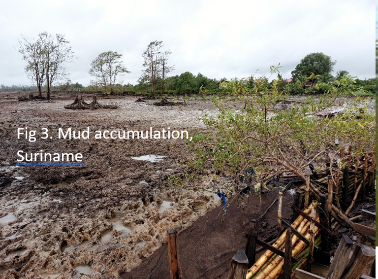
Mangroves provide multitudes of ecosystem services to coastal communities, including erosion and flood protection. They reduce hazard intensity on landward margins by attenuating waves through their root systems, capturing sediments and building soils (IPCC 2022). Guyana and Suriname are extremely vulnerable to the impact of coastal flooding and erosion (Dasgupta et al 2009) with >85% of the populations living along the narrow coastal plain which lies below mean sea level. Severe land losses have already occurred due to mangrove/land erosion (eg Figures 1,2,3) with inland flooding > 2 km observed during episodes of moderate surge coinciding with high tide. Sea walls can provide protection but are expensive to build and maintain, and may be undermined by erosion leading to catastrophic failure, and also disrupt other coastal systems, such as mangroves.
To explore longer-term, cheaper NBS, AdeKUS have trialled STUs in the region for over 10 years. These work by trapping sediment, giving seedlings a stable environment in which to establish themselves. Similarly, the Guyana Government is currently installing groyne defences along areas defended by a sea wall, to encourage sediment accumulation along the sheltered side, and hence mangrove growth. However these interventions may not work under more extreme conditions, and the physical/numerical evidence for the success of these interventions at the local scale in these areas, has not yet been explored. Documented evidence of impact is needed to support evidence-informed policy and strategy, and promote best practice and action locally.


Click on an image to expand
Methodology
Outputs: The aim of the PhD is to model how well existing or planned coastal defence structures capture and retain sediment to enable mangrove growth under a range of physically plausible environmental conditions along the coastlines of Suriname (Weg naar Zee, Coronie, Bigi Pan) and Guyana (Georgetown, East Coast).
Novelty: Studies are needed that examine a range of factors (eg wind direction, wave height, current strength, sediment transport) and their interaction with coastal defence structures affecting mangrove response at the local scale, as these are highly dependent on site specific variations (Wilson 2017) and drivers of change have not been well quantified in many parts of the world due to data constraints (Osland et al 2016). This research will therefore enhance understanding of the local processes acting on coastal systems at a local level and address knowledge gaps by developing robust new evidence and knowledge that can inform local and international coastal protection strategies and policies.
Modelling: Tailored to the student interests, modelling of the structures can take various forms.
(i) Scaled experiments: Experimental work will include hydraulic lab experiments conducted in controlled conditions to validate models for a variety of sediment trap designs and materials using flume experiments in the hydraulics lab at (1) Newcastle University (Flume Spec: 1m width; 12m length; flow rate 10-450l/s; positive slope 0-1/20; model mounting capability with viewing window in the base and full depth, glass side panels over full length; sediment capture and measurement capability; electro-magnetic flow meter in main delivery pipe; accurate depth and velocity measurement; 4K cameras to capture dynamic flow regime), and (2) AdeKUS – (larger flume, option to include local materials).
(ii) Computation Modelling: A variety of approaches can be investigated to capture the behaviour of the sediment traps informed by data from field sites and lab experiments including:
1. Physically-based hydrodynamic models of structures.
2. Physics-informed machine learning (PIML) models.
3. Semi-empirical models developed using standard statistical techniques.
Successful model designs may be built and implemented in the field and allow physical verification of the modelling results.
Datasets: The research will make use of empirical evidence from currently operating schemes. Publicly available historical remote sensing and recently collected drone imagery, will be used to pinpoint specific climatic events which have caused major environmental change guiding modelling thresholds. Model parameters will be informed by field-observations (collected 2024-26) by the project team under the UK-DEFRA-sponsored GCBC ENHANCES project, including near and off-shore currents and wave heights, wind and other meteorological data, water parameters (including turbidity, temperature, conductivity and pH) and sediment accumulation measurements.
Field work: New data informed by modelling needs will be collected from the field during 1-2 field campaigns, supported by AdeKUS.
Project Timeline
Year 1
1. Comprehensive literature review of the latest developments in coastal defence and sediment trapping structures such as groynes and leaky barriers, methods for modelling such structures and the rapidly developing area of physics-informed machine learning (PIML) to inform the direction of the research.
2. Gathering evidence about the impacts of existing structures in our field sites.
3. Planning the scaled experiments and computational modelling approaches and experiments for a range of conditions.
4. First field visit to Suriname/Guyana to set up data-gathering (eg small-scale sediment trapping units each side of physical structures) and refine modelling parameters.
5. Journal paper: review of state-of-the-art.
Year 2
1. Work with AdeKUS/NAREI to collect data to inform modelling.
2. Build, refine, and run scaled and physical models to gather results.
3. Calibrate and validate models where possible.
4. Present results at European conference.
5. Journal paper on one aspect of modelling.
Year 3
1. Second field visit to Suriname/Guyana to disseminate results and finalise data collection.
2. If possible showcase best designs for AdeKUS to build structures in the field.
3. Gather data on success of structures.
4. Present results at international conference.
5. Journal paper on results.
Year 3.5
1. Complete thesis, submission and viva
Training
& Skills
The candidate will have the opportunity to gain valuable skills in the context of (a) developing analytical and empirical physical and hydrodynamic models, experimental design, data integration and analysis; (b) knowledge of hydrological processes and the functioning of tropical coastal systems; (c) nature based and hybrid coastal protection methods. The student will make use of one-to-one coaching by the project team and the training facilities offered by the supervising universities. Training will also include attendance at national/international training events and conferences.
References & further reading
Winterwerp J.C., Bayney A., Engel S., Jack L., Mosely K., Smits B. (2025) Mangrove recovery by habitat restoration using nature-based solutions. Ecological Engineering 212. https://doi.org/10.1016/j.ecoleng.2025.107520
Toorman, E.A. et al. (2018). Interaction of Mangroves, Coastal Hydrodynamics, and Morphodynamics Along the Coastal Fringes of the Guianas. In: Makowski, C., Finkl, C. (eds) Threats to Mangrove Forests. Coastal Research Library, vol 25. Springer, Cham. https://doi.org/10.1007/978-3-319-73016-5_20
Brunier G., Anthony E.J., Gratiot N., Gardel A. 2019 Exceptional rates and mechanisms of muddy shoreline retreat following mangrove removal. Earth Surface Processes and Landforms 44 (8) 1559-1572 https://doi.org/10.1002/esp.4593
Guzman A., Castano-Isaza J., Ferguson S., Bovolo C.I. et al (2018) Suriname Coastal Resilience Assessment. World Bank Report number 130439 https://documents.worldbank.org/en/publication/documents-reports/documentdetail/684611538551863364
Best, Ü. S. N., van der Wegen, M., Dijkstra, J., Reyns, J., van Prooijen, B. C., and Roelvink, D.: Wave attenuation potential, sediment properties and mangrove growth dynamics data over Guyana’s intertidal mudflats: assessing the potential of mangrove restoration works, Earth Syst. Sci. Data, 14, 2445–2462, https://doi.org/10.5194/essd-14-2445-2022, 2022.
Hewett, C.J.M., Wilkinson, M.E., Jonczyk, J. & Quinn, P.F. 2020. Catchment Systems Engineering: An Holistic Approach to Catchment Management. WIREs Water. doi: 10.1002/wat2.1417
Leakey, S., Hewett, C., Glenis, V., Quinn, P., (2020) ‘Modelling the Impacts of Leaky Barriers with a 1D Godunov-Type Scheme for the Shallow Water Equations’, Water, MDPI, 12 (371).
Karniadakis, G.E., Kevrekidis, I.G., Lu, L. et al. (2021). Physics-informed machine learning. Nat Rev Phys 3, 422–440 https://doi.org/10.1038/s42254-021-00314-5
