IAP-25-078
AI-Driven Satellite Embeddings for Fine-resolution Mapping and Tracking Global Coastal Vegetated Ecosystem Change (2017-2024)
Coastal vegetated ecosystems store and bury significant quantities of carbon yet face growing pressures from development and climate change. Robust, consistent global mapping is essential for their conservation, restoration and biodiversity.
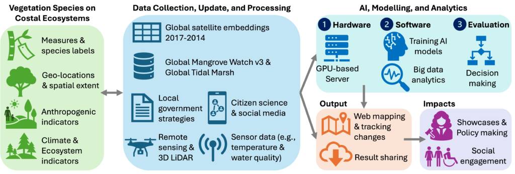
This project will harness AlphaEarth Foundations (AEF), i.e., Google DeepMind’s new AI model that integrates petabytes of Earth-observation (EO) data, to map and monitor global coastal ecosystem change across mangroves, salt marshes, seagrass beds and coastal shrublands. In particular, AEF’s public Satellite Embedding V1 dataset provides annual, 10m-by-10m embeddings (2017-2024) derived from optical, radar and LiDAR sources (e.g., Landsat and Sentinel-1/2), enabling consistent, scalable mapping from local to global scales.
Early adopters (e.g., Global Ecosystems Atlas) already report using AEF’s embeddings to help countries classify previously unmapped ecosystems such as coastal shrublands, highlighting their value for policy-relevant products. Utilising these state-of-the-art techniques, the successful candidate will address fundamental questions in our understanding of coastal ecosystems and their evolution under a changing climate and human pressure. Specific research questions could include:
1. How accurately can AEF embeddings delineate and track 2017-2024 changes in mangroves, salt marshes, seagrass and coastal shrublands relative to best-available baselines?
2. What combinations of temporal signals and ancillary drivers (e.g., elevation, wave exposure, tidal regime) most improve class separation and change detection?
3. How can we quantify and communicate uncertainty to decision-makers (e.g., explainable AI) to maximise our ability to manage coastal ecosystems for ecological and biogeochemical benefits?
Click on an image to expand
Image Captions
Project framework
Methodology
• Data & platform: Use Satellite Embedding V1 (annual 2017–2024, 10m-by-10m) as the core feature space from Google Earth Engine (GEE); add DEM, shoreline, and/or tide products and curated labels; process at the fine-grained, local scale with careful projection handling per GEE guidance.
• Training labels & baselines: Compile global references from Global Mangrove Watch v3 (Bunting P et al., 2022) and Global tidal marsh (2020, 10 m) (Worthington et al. 2024) and regional seagrass datasets to generate harmonised training/validation sets for stratified coasts.
• Modelling: Evaluate classical machine learning (ML) methods (e.g., Random Forest and XGBoost) and deep learning heads (e.g., temporal CNN/Transformer) on top of AEF embeddings; test temporal stacks (2017à2024) for change detection; compare with non-AEF feature baselines.
• Validation: Multi-scale accuracy assessment using withheld labels, independent inventories and field campaigns in Scottish estuaries (e.g., salt-marsh & seagrass ground checks, GPS transects, and UAV orthos) led with St Andrews; uncertainty maps (calibration plots, conformal prediction).
• Use-case pilots: explore UK (e.g., Forth-Clyde and Moray Firth), West Africa, and South-East Asia; deliver open reproducible notebooks and coastal change dashboards.
• Knowledge exchange: Engage with Global Ecosystems Atlas and national users for feedback and co-design.
Project Timeline
Year 1
The successful candidate will have scope to adapt the project’s direction as they investigate the key research gaps, but we anticipate an approximate research timeline as follows:
• Literature & data acquisition; Prototype AEF-based classifiers on UK pilot; baseline 2020 extent benchmarks.
• First manuscript: AEF feasibility for coastal vegetated ecosystem mapping (UK case).
Year 2
• Scale to 3 regional pilots; implement temporal change detection (2017-2024).
• Field validation campaigns (Scotland) + uncertainty quantification.
• Second manuscript: Global coastal change with AEF (methods & validation).
Year 3
• Global mapping at 10m-by-10m; sensitivity/ablation studies; stakeholder co-design of outputs.
• Third manuscript: coastal vegetated ecosystem changes and drivers (global synthesis).
• Public release: datasets, code and documentation.
Year 3.5
• Thesis write-up.
• Policy briefs.
• Data deposition.
• Conference paper(s).
Training
& Skills
The student will learn GeoAI & ML (Python/PyTorch), GEE large-scale data processing, coastal geomorphology & blue-carbon science, field survey (GNSS/UAV), open-science workflows, stakeholder engagement and research ethics. Formal training via UofG & Iapetus; optional short courses (advanced GEE; uncertainty quantification).
At UoG, we offer postgraduate research students in Environmental Sciences a number of benefits in addition to exceptional teaching and supervision, including a wide-ranging and responsive research student training programme which enables students to enhance their skills and successfully complete their studies; mobility scholarships of up to £4000 to enable students to undertake work in collaboration with an international partner; a diverse programme of activities which will ensure students feel part of the wider-research community; a residential trip; the opportunity to engage with industry-partners through training, placements and events, etc.
At the University of St Andrews, the student will be part of the Environmental Change Research Group and the Bell Edwards Geographical Data Institute. Further training in key transferable skills is available through the International Education and Lifelong Learning Institute (IELLI) at the University of St Andrews, which provides learning and teaching support through combining educational development, pedagogical workshops, courses in oral and written communication, and opportunities for media and public engagement.
References & further reading
• DeepMind: AlphaEarth Foundations blog & tech note (model + embeddings): https://deepmind.google/discover/blog/alphaearth-foundations-helps-map-our-planet-in-unprecedented-detail/
• Google Earth Engine. Satellite Embedding V1 dataset & tutorials (annual 2017–2024, ~10 m; multi-sensor incl. optical, radar, LiDAR): https://developers.google.com/earth-engine/datasets/catalog/GOOGLE_SATELLITE_EMBEDDING_V1_ANNUAL
• Global Ecosystems Atlas (initiative overview; AEF use cases): https://globalecosystemsatlas.org/
• Global Mangrove Watch v3 (baseline & change). https://doi.org/10.3390/rs14153657
• Worthington et al. 2024. Global tidal marsh (10 m, 2020). https://doi.org/10.1111/geb.13852
• Smeaton, C, Barlow, NLM and Austin, WEN (2020) Coring and compaction: Best practice in blue carbon stock and burial estimations. Geoderma, 364. 114180. ISSN 0016-7061. https://doi.org/10.1016/j.geoderma.2020.114180