IAP-25-069
Drivers of changing geohazard exposure and risk in the Hindu-Kush Himalaya
The Hindu Kush Himalaya (HKH) is one of the world’s most dynamic mountain systems, characterized by steep terrain, active tectonics, and climatic variability [1]. Warming temperatures and changing precipitation patterns in the Hindu Kush Himalaya are increasing the frequency and intensity of geohazards, endangering mountain communities, infrastructure, and downstream regions reliant on the area’s fragile resources [2]. Whilst recent work has demonstrated tentative links between urbanisation, climate change, and geohazard occurrence [3], the relative contributions of land-use alteration, exposure dynamics and climatic changes to these risks remain poorly quantified. As a result, questions remain around the potential future efficacy of development choices or mitigation efforts that seek to reduce the impacts of geohazard risk across the HKH [4].
In a significant methodological development, the project will look to develop existing methods for automated mapping of anthropogenic and geohazard-related landscape disturbance (e.g., 3), integrating satellite imagery from the freely available ESA Sentinel archives. The resulting time series data cubes of landscape change will then be used to analyse evolving temporal dynamics alongside newly available datasets on population exposure, infrastructure development and projected climate impacts. The project will focus on exploring the temporal characteristics of geohazards at their intersections with: linear infrastructure development; different transboundary policy contexts; spatially variable climate predictions; and, the impact of and response to large-scale triggering events. The project will build a critically important evidence-base to better understand the root causes and drivers of changes in losses associated with geohazards. The student will use this analysis to generate outputs to inform future investments and policies around risk reduction and development in mountain regions more widely by the project end-user partners.
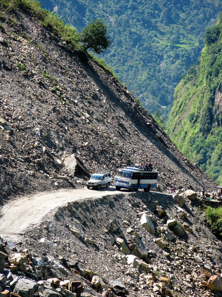
Click on an image to expand
Image Captions
The Arniko Highway crossing a large and unstable landslide at Daklang, Sindhupalchok, Nepal (O Boyd, 2025)
Methodology
The project will involve a range of methodologies, from remote sensing and geospatial analyses, numerical analysis of time-series data; field-working; and risk and science communication linking to disaster risk reduction policy, including:
– Cloud based generation of image stacks for time series analysis geohazard change, working with project collaborators.
– Automated mapping of geohazards using deep neural networks, paired with land-use change (urbanisation, road development, deforestation…), building on Chen et al., 2025..
– Collation and analysis of key infrastructure and population datasets (e.g., WorldPop, Open Street Map, Microsoft buildings and roads footprint data).
– Collation and analysis of gridded climate data, and climate projections / scenario data for the HKH.
– Field-based validation of remotely sensed geohazard mapping and monitoring.
– Geospatial analysis of evolving exposure and risk to population / assets.
– Research into development policies and risk mitigation priorities between HKH countries that influence the intersection of geohazards and exposure, working closely with collaborators.
Project Timeline
Year 1
Review of existing literature and identification of key datasets; training in the use of Google Earth Engine (GEE) for time series analysis of satellite imagery; visit to project collaboration partners at University of Washington. Initial testing and application of Sentinel-based landscape change analysis. Identification of field test areas for validation.
Year 2
Upscaling and refinement of automated mapping analysis across the overall HKH region; validation of outputs using existing hazard inventories and infrastructure data; collation of additional relevant exposure data. Comparison of outputs from different imagery and processing workflows. Attendance at UK / EU conference to present initial results. Analysis of spatial and temporal changes in geohazard occurrence and associated risk dynamics across HKH; analysis of climate data and modelled future climate projections;
Year 3
Exploration of national and trans-national policy frameworks and priorities around geohazard risk reduction. Present research findings at international conference. Completion of full draft of published outputs and/or thesis.
Year 3.5
Complete write-up of thesis and associated publications. Present findings at international conference, and explore opportunities for dissemination with collaborative partners.
Training
& Skills
This project will provide the student with a wide range of skills in remote sensing, hazard and risk assessment, and applied geomorphology. The student will be trained in geohazard mapping using machine learning and artificial intelligence the state-of-the-art facilities at the Geography Department at Durham University. Additional training will be provided through visits to projects partners at the University of Washington on using deep learning for geohazard time series generation.
The student will be a member of the dynamic Hazards and Surface Change Cluster in Geography at Durham (https://www.dur.ac.uk/geography/slic/). The student will also participate in a broad range of skills training provided in-house at Durham through the award-winning Durham Centre for Academic Development (DCAD) (thesis writing, writing for publication, presentation skills, enterprise skills etc.) and from the range of environmental science training provided as part of the IAPETUS Doctoral Training Partnership framework.
Through project collaborators/supervisors the student will have the opportunity to develop a network of national and international collaborators in the general study area. The student will also attend and contribute to the programme of regular departmental seminars and discussion groups as well as National and International conferences to support their general development as a scientist. The student will be encouraged to write scientific papers for publication during their PhD. This will be a major benefit to their career, and they will be well supported through this process by the experienced supervisory team.
References & further reading
1. Rusk, J., Maharjan, A., Tiwari, P., Chen, T.H.K., Shneiderman, S., Turin, M. and Seto, K.C., 2022. Multi-hazard susceptibility and exposure assessment of the Hindu Kush Himalaya. Science of the total environment, 804, p.150039.
2. Stanley, T.A., Soobitsky, R.B., Amatya, P.M. and Kirschbaum, D.B., 2024. Landslide hazard is projected to increase across High Mountain Asia. Earth’s Future, 12(10), p.e2023EF004325.
3. Chen, T.H.K., Kincey, M.E., Rosser, N.J. and Seto, K.C., 2024. Identifying recurrent and persistent landslides using satellite imagery and deep learning: A 30-year analysis of the Himalaya. Science of The Total Environment, 922, p.171161.
4. Adler, C , et al. (eds), CCP5 – Mountains; Climate change 2022: impacts, adaptation, and vulnerability : Contribution of Working Group II to the Sixth Assessment Report of the Intergovernmental Panel on Climate Change . CUP, Cambridge , pp. 2273-2318.