IAP-25-104
How does ice flow enhancement and rearrangement impact the West Antarctic Ice Sheet?
The West Antarctic Ice Sheet contains enough ice to raise global sea levels by approximately 3.3 metres. Ice sheets currency contribute about one-third of global sea level rise, primarily by moving ice from land to ocean through outlet glaciers and ice streams. This contribution is expected to increase alongside predicted climate warming. The key to predicting how ice sheets respond to future climate change requires us to understand how ice has flowed in the past, and the physical properties of the ice.
The Weddell Sea sector contains 20% of Antarctica’s continental ice volume, however until recently, little was known about its past and present ice flow due to a lack of existing data. Over the past decade, a synthesis of geophysical observations, geological and geomorphological analyses, and numerical modelling experiments has led to two competing scenarios: (1) the ice sheet became progressively smaller over time; and (2) it rapidly retreated to an extent smaller than today, before re-expanding to its current extent (Siegert et al. 2019).
In two stages, this PhD studentship will leverage an extensive set of ice-penetrating radar datasets to investigate how past ice flow in the Weddell Sea Sector has changed over the last glacial cycle. The student will then be able to assess whether the radar-derived results are consistent with each of the two proposed historical scenarios.
Stage 1 of the PhD project identifies and maps internal ice deformation structures such as folds, buckles, and disrupted layering. These internal ice sheet structures are diagnostic of past ice flow patterns and change. To date, such structures have been identified in individual outlet glaciers, but not systematically characterised and mapped across the sector. They are important because they confirm present-day ice flow patterns, and evidence zones of past ice flow change (e.g. if currently slow flowing ice is underlain by folded layers indicative of fast flow).
Stage 2 of the PhD project analyses the ice crystal fabric of Weddell Sea outlet glaciers using the same radar datasets. As ice flows, its crystals gradually align in preferred orientations, forming a “fabric” that records its past flow patterns. This fabric also affects how easily the ice can deform in specific directions, which significantly influences the speed and direction of future ice flow. Because of this relationship between crystal fabric and mechanical properties, characterising the crystal fabric properties of an outlet glacier can therefore help to improve the accuracy of their respective sea level rise projections for this sector of the ice sheet (by constraining the ‘real world’ properties of ice sheet models).
Click on an image to expand
Image Captions
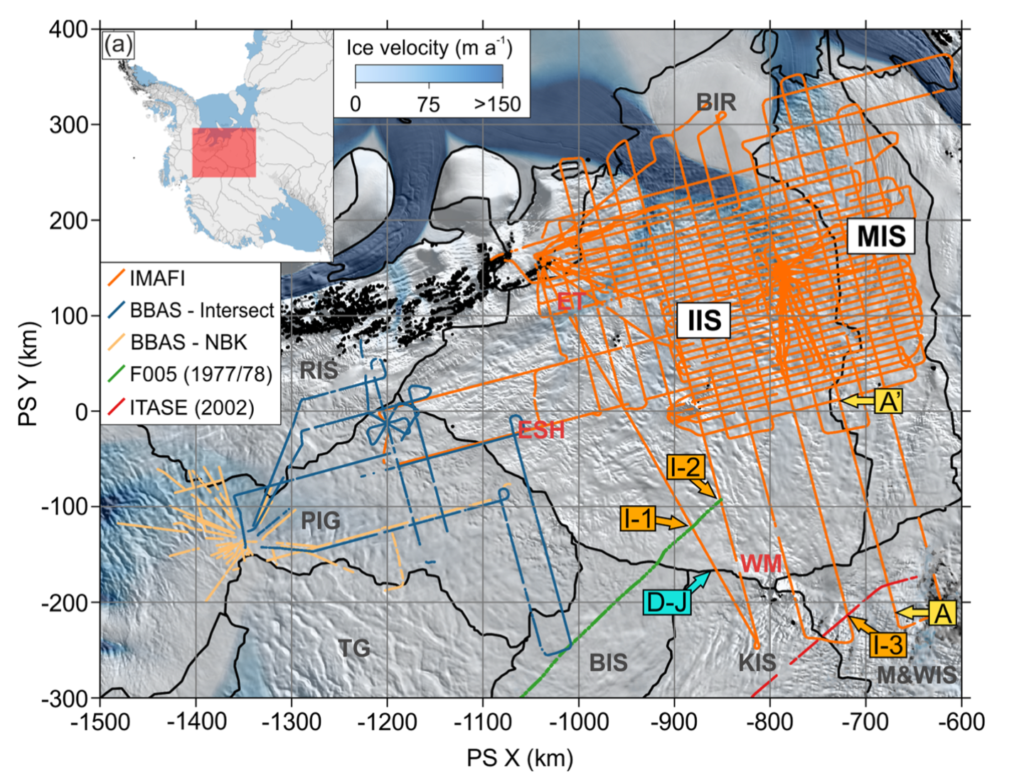
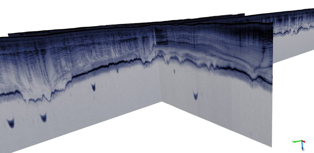
A wealth of radar datasets already exist across the Weddell Sea Sector, conducted through 4 distinct field seasons: (1) F005 in 1977-78; (2) ITASE in 2002, (3) BBAS in 2004-2005, and (4) IMAFI in 2010-2011. The radar datasets cover many regions and features of interest, including Bungenstock Ice Rise (BIR); Institute Ice Stream (IIS); Möller Ice Stream (MIS); Pine Island Glacier (PIG); Thwaites Glacier (TG); Bindschadler Ice Stream (BIS); Kamb Ice Stream (KIS); Mercer and Whillans Ice Streams (M&WIS); Ellsworth Trough (ET); Ellsworth Subglacial Highlands (ESH) and Whitmore Mountains (WM). A series of additional radar surveys will be conducted in the Austral summers of 2027 and 2028 as part of the IGIS Project.,3D visualisation of ice-penetrating radar data from the Institute Ice Stream, Weddell Sea Sector of Antarctica, with (i) evidence for strongly defined layers; and (ii) englacial deformation structures recording the history of ice sheet flow.
Methodology
This project is multidisciplinary, with opportunities for the student to develop expertise in ice-penetrating radar geophysics, geospatial analysis, geomorphology, and glaciology. The student will apply innovative radar analysis techniques to these datasets to extract measurements of ice fabric, which indicate links between its crystal alignment and flow patterns (e.g. Young et al. 2021, Gerber et al. 2023). Completion of ice fabric analysis will also highlight certain directions of past ice flow, thereby shedding further light into the hypotheses proposed by Siegert et al. (2019). Structural investigations of these radar datasets to analyse disrupted and folded internal and near-basal reflections from the ice (e.g. Ross et al. 2020) will also be conducted to further constrain the history of past ice flow rearrangement across the sector through analysis of patterns in the ice layers. The resulting analyses will be synthesised to produce an updated map of the spatial and temporal history of ice flow across the Weddell Sea Sector.
Geophysical data analysis underpins all stages of the project. Morphometric re-analysis of radargram englacial layers will be implemented using the Matlab or Python programming languages, working closely with supervisors Ross and Young. The student will also analyse ice crystal patterns using bespoke geophysical processing techniques of exiting and forthcoming datasets, through adapting procedures established by supervisors Young and Martín. Working alongside supervisors Martín and Henry, the student can analyse ice-flow model outputs, validating radar-derived results that test the validity of the two proposed scenarios of past ice history. Although not mandatory for the success of the project, the student will through this process have the valuable opportunity to learn how to run ice sheet models, thereby further expanding their technical expertise to include numerical modelling.
Furthermore, the student will gain experience in geospatial analysis through the need to present and visualise results through Geographic Information Systems (GIS) software. At all points along the project, the student will be supported and mentored by the supervisory team, all who are at the forefront of their respective fields, and have extensive experience working in and researching the Weddell Sea Sector and the West Antarctic Ice Sheet.
Project Timeline
Year 1
Develop key skills in radar processing and glaciology using the Matlab or Python coding platforms. Analyse internal layering imaged from radar data to reconstruct possible configurations of past ice flow history over the West Antarctic Ice Sheet (with supervisors Young and Ross). Apply and, if accepted, attend the 10th ESA Course in Radar Polarimetry.
Year 2
Synthesise existing radar datasets and field-derived results to map ice fabric across the Weddell Sea Sector, thereby reconstructing its ice flow history and possible ice flow rearrangement (with supervisors Young and Martín). Establish a radar-derived fabric methodology to extract flow enhancement–a crucial input needed to improve the accuracy of ice flow models used to predict sea level rise (with supervisors Martín and Henry). Present outcomes at a national conference in glaciology.
Year 3
Complete radar-derived morphometric and ice crystal fabric analyses. Collaborating with ice sheet modellers, analyse outputs from anisotropic ice sheet models to test hypotheses of past ice flow (with supervisors Martín and Henry). Present outcomes at an international conference. Draft papers and begin writing thesis.
Year 3.5
Write up and submit thesis. Finalise manuscripts for publication. Attend an international conference.
Training
& Skills
Techniques in geophysical data analysis and radioglaciology–both facilitated through the Matlab or Python coding languages and programs–will form the core of this project. Geospatial analysis will also be used to visualise and present results. Development of these necessary skills will be facilitated through in-house expertise in St Andrews, Newcastle, and the British Antarctic Survey, via IAPETUS2 and NERC researcher training events, and via internationally recognised summer schools, of which several that align with the project have been identified.
Further training in key transferable skills is available through the International Education and Lifelong Learning Institute (IELLI) at the University of St Andrews, which provides learning and teaching support through combining educational development, pedagogical workshops, courses in oral and written communication, and opportunities for media and public engagement. The student will also benefit from cross-disciplinary training as well as the opportunity for an optional 3-month policy secondment, both provided as part of the IAPETUS DTP.
This studentship will run alongside the NERC-funded IGIS project (Impact of deep subglacial groundwater on ice stream flow in West Antarctica) led by supervisors Kulessa and Young. As part of IGIS, new polarimetric radar datasets will be collected to fill gaps in existing datasets. The studentship conceptually aligns with the goals of IGIS, whilst also being part of a larger team spanning several institutions. Although no fieldwork is officially included as part of the PhD project, there may be the opportunity to join other groups undertaking fieldwork.
The student will be encouraged to present their work at conferences and seminars at St Andrews and at collaboration institutes, and attend relevant national and international conferences throughout the course of their PhD research. With guidance from their supervisory team, the student is also encouraged to apply for small grants, which will allow them to gain experience with writing funding proposals.
Informal enquiries are welcome through contacting Dr TJ Young (tjy1@st-andrews.ac.uk) and/or Prof Neil Ross (neil.ross@newcastle.ac.uk).
References & further reading
Gerber, T. A., Lilien, D. A., Rathmann, N. M., Franke, S., Young, T. J., et al. (2023) Crystal orientation fabric anisotropy causes directional hardening of the Northeast Greenland Ice Stream. Nature Communications, 14(1), 2653. https://doi.org/10.1038/s41467-023-38139-8
Ross, N., Corr, H., & Siegert, M. (2020) Large-scale englacial folding and deep-ice stratigraphy within the West Antarctic Ice Sheet. The Cryosphere, 14(6), 2103–2114. https://doi.org/10.5194/tc-14-2103-2020
Siegert, M. J., Kingslake, J., Ross, N., Whitehouse, P. L., Woodward, J., Jamieson, S. S. R., Bentley, M. J., Winter, K., Wearing, M., Hein, A. S., Jeofry, H., & Sugden, D. E. (2019) Major Ice Sheet Change in the Weddell Sea Sector of West Antarctica Over the Last 5,000 Years. Reviews of Geophysics, 57(4), 1197–1223. https://doi.org/10.1029/2019RG000651
Winter, K., Woodward, J., Ross, N., Dunning, S. A., Bingham, R. G., Corr, H. F. J., & Siegert, M. J. (2015) Airborne radar evidence for tributary flow switching in Institute Ice Stream, West Antarctica: Implications for ice sheet configuration and dynamics. Journal of Geophysical Research: Earth Surface, 120(9), 1611–1625. https://doi.org/10.1002/2014JF003432
Young, T.J., and Smith, E. C. (2021) The softness of ice, how we measure it, and why it matters for sea level rise. EGU Blogs: Cryospheric Sciences. https://blogs.egu.eu/divisions/cr/2021/06/25/softness-ice-fabric/
Young, T. J., Martín, C., Christoffersen, P., Schroeder, D. M., Tulaczyk, S. M., & Dawson, E. J. (2021) Rapid and accurate polarimetric radar measurements of ice crystal fabric orientation at the Western Antarctic Ice Sheet (WAIS) Divide ice core site. The Cryosphere, 15(8), 4117–4133. https://doi.org/10.5194/tc-15-4117-2021